Chapter: Civil : Structural dynamics of earthquake engineering
Asian tsunami disaster
Asian tsunami disaster
The main tremor
occurred at 7.58 local time on 26 December 2004 (00.58 GMT) of magnitude 9
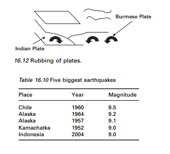
ŌĆśmega thrustŌĆÖ at Aceh, Sumatra. The scale of slippage was quite heavy, 30 km,
from seafloor at 1200 km a stretch of Indian Plate thrust up to 20 m under the
Burmese plate, raising the seafloor by several metres as shown in Fig. 16.12.
The Indian Plate and Burmese Plate rubbed each other and about 1200 km of the
latter was snapped off. Historically this was the fourth biggest earthquake in
the last century. The others are given in Table 16.10.
The epicentre of this
earthquake lay 250 km south-east of Banda Aceh, Indonesia and 1600 km
north-west of Jakarta. The energy released was

equivalent to 475 000 kilotonnes of TNT or 23 000
Hiroshima-sized atom bombs. The earthquake caused a tsunami. Tsunami is a
Japanese word, ŌĆśTsuŌĆÖ meaning harbour and ŌĆśnamiŌĆÖ meaning wave. Some people
prefer to use the term tidal wave, but this is a misnomer. Scientists call this
a seismic sea wave. Seismic sea waves are due to an earthquake but tsunami
waves may be due to non-seismic activity such as a landslide or meteorite
impact. Wind waves have a period of 10 s with a wavelength of 150 m, and
shallow tsunami water waves have a wavelength of 100 km and T = 1 hour.
A wave behaves as a shallow water wave if the ratio between water depth and
wavelength gets very small.

where h = 1000 m and v = 200 m/s or
700 km/h.
The rate at which a
wave loses its energy is inversely related to its wavelength. As a tsunami
leaves the deep water of the open ocean, it travels into shallow water near the
coast it transforms. As water depth decreases, the tsunami slows and because of
the shoaling effect, the tsunami magnitude grows several metres in height.
Thirteen countries, including Indonesia, Sri Lanka, India, Thailand, Myanmar,
Malaysia, Maldives and Sumatra were affected. It is estimated that more than
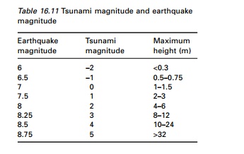
250 000 people died and many were injured. Table. 16.11 gives the equivalent
tsunami magnitude corresponding to the earthquake magnitude.
1
Unfamiliarity with warning signs
In the minutes preceding a tsunami strike, the sea
often recedes temporarily from the coast. The total energy released = 2.0
exajoules (12 ’āŚ 1018 joules), enough to boil 150 litres of water for
every person on Earth. The 2004 tsunami resulted in an oscillation of the
EarthŌĆÖs surface of about 20ŌĆō30 cm. This was felt across the planet up to
Oklahoma. It has shortened the day by 2.68 microseconds. The smaller islands of
Sumatra have moved by 20 m. A tsunami in deep water waves forms only a small
hump that is barely noticeable and harmless, which travels at a very high speed
500ŌĆō1000 km/h. In shallow

water near the coastline a tsunami slows down to
only 10 km/h. In doing so,
it forms large destructive waves. Because the 1200 km of the fault line affected by the earthquake were in nearly northŌĆōsouth direction, the greatest strength of tsunami waves were in eastŌĆōwest direction. The tsunami reached the Indian Ocean in 2 hours. In South Africa, which is 8500 km from Sumatra, a 1.5 m high tide surged on shore after 16 hours.
Damage
mechanisms due to earthquakes
’éĢ Very large
inertial forces develop in a structure due to earthquake ground motion and
could cause collapse.
’éĢ
Earthquakes instigate landslides and other surficial movements.
’éĢ They
induce soil consolidation or liquefaction beneath the foundation.
’éĢ Sudden
fault displacement in close proximity to a structure is hazardous to pipelines,
canals and dams.
’éĢ Tsunamis
are seismically induced water waves that may threaten coastal regions.
’éĢ
Earthquakes may induce fire and explosions.
Summary
Ground shaking poses the most potentially hazardous damage mechanism to structures and its effects may be widespread. Hence the response of structures to earthquake ground motion should be addressed.
Related Topics