Chapter: Civil : Structural dynamics of earthquake engineering
Earth’s crust: Faults
Faults
Earthquakes generally
originate on a plane of weakness in the Earth’s crust called a ‘fault’.
Faults are formed when two crustal rock beds slip relative to each other.
Faults are classified according to the directions of relative slippage.
1 Strike‚Ä'slip
fault
If the movement or
slippage is primarily horizontal it is a strike‚Ä'slip fault. They
can either be left lateral or right lateral (see Fig. 16.3).
2 Dip‚Ä'slip
fault
If the slippage is vertical it is called a dip‚Ä'slip
fault. Such faults may be normal faults or reverse faults. A fault that
reveals itself on the Earth’s surface due to past earthquake activity is known
as an earthquake fault. The well-noted ‘San Andreas’ fault, for example,
emerges to the surface between Point Arena and the Gulf of California and
reveals its presence by a linear trough in the Earth’s surface approximately
250 km long. The San Andreas fault occurs along the intersection of the Pacific
Plate and the North American
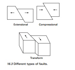
Plate and has a total
length of approximately 960 km, extending almost vertically into the Earth to a
depth of 30 km.
Earthquakes often occur
at ‘active faults’. Active faults are faults for which there is a past history
and movements or deformation. The San Andreas fault system has been active
during the past 200 years and other faults have been active for thousands of
years.
Most earthquakes occur
in the world along the boundaries of the tectonic plates which are called inter-plate
boundaries (e.g., 1897 Assam earthquake). A number of earthquakes can also
occur within the plate itself away from the plate boundaries (e.g., 1993 Lattur
earthquake). These are called intra-plate boundaries. In both
types of earthquake, the slip generated at the fault during earthquake
is along both vertical and horizontal directions (called dip‚Ä'slip), and
lateral directions (called strike‚Ä'slip), with one of them dominating at
some times.
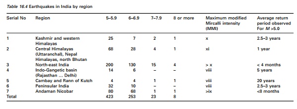
In the Indian
subcontinent, part of the Indo-Australian Plate is pushing against the Eurasian
Plate along the Himalayan belt. Therefore the Himalayan belt is highly seismic
(see Table 16.3), whereas peninsular India, which is not traversed by any plate
boundary, is relatively less seismic. Earthquakes became frequent after the
construction of Koyna Dam and these are regarded as reservoir-induced (or
artificial). However, the Latur earthquake of 1993, which occurred in what was
previously considered to be the most stable region on the Earth, implies that
no region is entirely safe from devasting earthquakes.
When considering the regional distribution of
earthquakes in the Indian subcontinent, the whole area can be divided in to the
following seismic regions:
Kashmir and western Himalayas.
•
Central Himalayas (including Nepal).
•
North-east India.
•
Indo-Gangetic basin (Rajasthan).
•
Cambag and the Rann of Kutch.
•
Peninsular India.
•
Andaman and Nicobar Islands.
The seismic activities of these regions are summarized
in Table 16.4.
Earthquake belts
in the world
Circum-Pacific belt:
This follows the region around the Pacific Ocean from Japan, China,
Alaska Aleutians, California (San Andreas fault system),
Mexico, Equador, Peru, Chile and New Zealand. These
are the areas characterized by plate subduction, active volcanoes, strain
build-up and periodic release, causing earthquakes.
•
Mid-Atlantic Ridge: This follows the
lines of Mid-Oceanic Ridges from near the North Pole to the equator, turning around
South Africa and ends up to Rift Valley region of East Africa. Seismicity is
low in this region.
•
The Alpine-Himalayan Trans-Asiatic Belt:
The Alpine mountain areas of Europe, North Africa, Asia Minor, Caucasus,
Turkey, Iraq, Iran, Himalayan region such as Kashmir to Assam, Myanmar and
Philippines. This zone passes through boundaries of continental crustal plate
with high mountain ranges where intense compression takes place.
Related Topics