Chapter: 11th Geography : Chapter 5 : Hydrosphere
Ocean movements
Ocean
movements
Water in the ocean is never in a state of rest. Ocean water is always in motion. It moves horizontally as well as vertically. The movement of ocean water takes place in three different ways as waves, tides and ocean currents.
Waves
The waves are oscillating movements
in the ocean water which transfer energy from place to place. They are caused
by friction of wind on the surface of water or any other disturbances’ on the
sea bottom.
Parts of Waves
1. Crest: The upper or highest part of a wave is called the crest. (Figure
5.16)
2. Trough: The lowest part of a wave is called the trough.
3. Wave
height: The vertical
distance between the crest and the trough is known as wave height.
4. Wave
length: The horizontal
distance between two crests or two troughs is known as wave length.
5. Wave
amplitude: Wave amplitude is one-half of the wave height.
6. Fetch: The distance of open water across which the wind can blow
without interruption is called fetch.
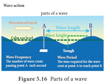
7.
Frequency: The number of wavelengths that pass a fixed point per unit of
time is frequency. Example, 100 waves per sec per cm.
8.
Period: The time taken by one wavelength to pass a fixed point is known as period.
9.
Velocity: Refers to speed and direction.
10. Steepness: Steepness of the wave is equal to the height divided by length.(H/L)
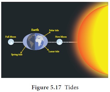
Tides
The rhythmic rise and fall of the sea
water due to gravitational pull of the moon and the sun is called a Tide. Isaac
Newton (1642– 1727) was the first person to explain tides scientifically. The
rise of seawater towards the land is known as High tide or flow tide. The fall
of seawater more towards sea is known as ‘Low tide water’ or ebb tide. On any
day there will be two high tides and two low tides. The highest high tide
occurs on full moon day and new moon day. It is known as spring
tide (Figure 5.17).
Spring tide happens when the sun, earth and moon aligned in straight line. The
lowest low tide is known as neap tide. It happens when the sun, earth and moon are
positioned at right angles.
The movement of ocean water as a
result of tidal action is known as a tidal current. In places of narrow coastal
inlet these tidal currents flow rapidly through the mouth with greater height
and velocity. For example in the Bay of Fundy, between Nova Scotia and New
Brunswick of Canada, the difference between high and low tides is as high as
14m. Ports which utilize the tidal current for entry and exit of ships from the
harbour are known as tidal ports. In India Kolkatta and Kandla are examples of
tidal harbours.
HOTS
Why does the highest
Tide occur when the
sun, earth and moon are aligned in a straight line?
The Gulf of Cambay and the Gulf of
Kutch in Gujarat on the west coast have the maximum tidal range of 11m and 8m
with average tidal range of 6.77m and 5.23m respectively. Tides help to clear
the sediments deposited by rivers on their bed and thus prevent siltation of
harbours. The energy of the tides is used to generate electricity. Tidal power
stations have been set up in UK, Canada, France and Japan. In India Gulf of
Khambhat, Gulf of Kutch and Sundarbans have scope for tidal energy production.
Fact
File
A harbour is a sheltered water body where ships are anchored. A port is
the area at the edge of a water body where boats and ships are docked, where
transfer of goods and passengers take place and where trading is facilitated.
Ocean currents
Large mass of moving water from one
part of the ocean to another in a definite direction is called as ocean
current. The movement is produced due to earth’s rotation, temperature
difference of ocean water, salinity, density and some extent
In the order of velocity ocean currents can be
classified as drifts, currents and streams. Drifts are movement of surface water of low velocity influenced by
prevailing winds, currents are
movement of oceanic water in definite direction and greater velocity and streams are larger mass of water moving
in a definite direction and much greater velocity than the drifts and currents.
Ocean currents are distinguished by the temperature they possess. When ocean
currents originate from equator it is termed as warm current. Likewise when a current starts from polar region it
is termed as cold current.
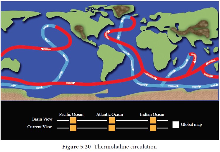
Vertical circulation of ocean water takes place due
to difference in salinity and temperature between the surface and the water
deep below. Upwelling is an oceanographic phenomenon that involves movement of
dense, cooler, and usually nutrient-rich water towards the ocean surface,
replacing the warmer, usually nutrient-depleted surface water. Down welling is
the process of accumulation and sinking of cold high saline water beneath
warmer or fresher water.
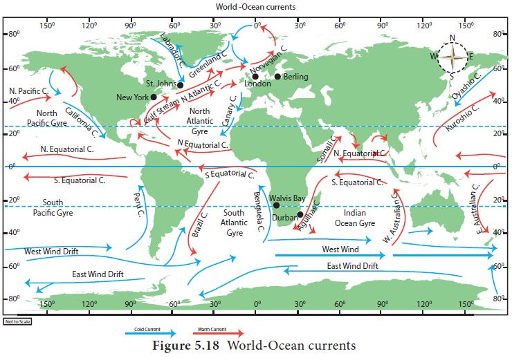
Major ocean currents of the world
In every ocean, there is circulation of ocean water
from Equator to pole and from pole to equator. The warm currents from the
equator flows over the surface of ocean towards the pole and sink to the bottom
of the ocean floor in the higher latitudes due to high density and flow towards
the equator to complete the circulation. This large scale circulation is known
as gyre.
The gyre circulates is clockwise in the northern
hemisphere and anti-clockwise in the southern hemisphere.
a. Ocean currents of the Pacific Ocean
1. North Equatorial current.
North equatorial current originates from Revilla
Gigedo island west of Mexico and flows towards the Philippines Island covering
a distance of about 12,000 km from east west. It is a warm current. It derives
from its water from the Californian current and the South east Monsoon drift
which flows north along the Mexican coast. The volume of water increases from
east to west as many small currents join it from right. It gets divided into
two and the northern branch joins the Kuroshio Current and the southern branch
abruptly turns and forms the Pacific counter current.
2. South equatorial current.
South equatorial current is originated due the
action of the trade winds from east to west. It is a warm current. It extends
for about 13,600km from east to west. It is stronger than the North equatorial
current. It is further divided into many branches due to the presence of many
islands and uneven surface topography.
3. Kuroshio current ( Black Tide)
It is a warm ocean current flowing in north
easterly direction up to 30o N latitude and it carries warm water
off the Formosa coast. It flows towards north and meets Oyashio cold current
off the Kuril Islands. It is also called as Japan current.
4. Oyashio Current( Parental Tide)
It originates from the Bering Strait and flows
towards south carrying cold water. It is a cold current. It meets with Kuroshio
warm current and Aleutian current.
5. Californian Current.
Californian current is flowing towards south along
the west coast of U.S.A between 48o N and 23o N
latitudes. It is cold current which exhibits great amount of up welled water.
When it enters the region of Trade winds, it is deflected to the right and
joins the equatorial current.
6. Peru Current.
Peru Current is perhaps the best studied ocean
current of the Pacific Ocean. Alexander Von Humboldt in 1802 noted the details
of the Peru Current. Hence, it is also known as Humboldt Current. It is a cold
current. It is flowing towards north along the west coast of South America
carrying cold water from northerly deflection of the Sub-Antarctica water
moving in 40o S.
7. El Nino or Counter current.
It is a warm counter ocean current of the pacific
equatorial waters flowing south ward at 400 m depth to a distance about 180 km.
8. West Wind Drift.
It is an easterly moving drift in the Pacific Ocean
extending from Tasmania to the South American coast. It is a cold current. The
speed of the drift is greater under the influence of Roaring Forties. It splits
into two branches and one moves south around the Cape Horn into the Atlantic
Ocean and the Other one moves northward along the Peruvian coast due to
deflection and joins the Peru Current.
b. Currents of the Atlantic Ocean
1. North equatorial current.
North equatorial current is flowing from east to
west. It is a warm current. It is situated between 5o – 20o
N latitudes. After leaving the west coast of Africa, it attains its main
characteristics. When it reaches the east coast of South America, it splits
into two branches and one branch called Antilles current is moving along the
coast of West Indies and other branch is diverted into the Caribbean sea.
2. South Equatorial current.
It is flowing south of equator within 0o
– 12o S latitude in between the coast of Africa and South America.
It is a warm current. It is a northern continuation of Benguela current. It is
stronger than the North equatorial ocean current. It is caused by the action of
Trade winds.
3. Gulf Stream.
Gulf Stream starts from the Gulf of Mexico and
carries warm waters into the colder latitudes. It is a warm current. It bends
with the coastline up to 40th parallel after which the direction is
almost to the east, due to the force and the direction of the westerlies and
the deflective force of the earth. It joins the labrador cold current near New
Found land, Canada after passing through the strait of Florida. The Gulf Stream
was discovered by Ponce de Leon in 1513.
4. Canaries
Current.
The ocean current flowing along the Western coast
of North Africa between Maderia and Cape verde is known as the Canaries
Current. It is a cold current. It is flowing towards south and merging with the
North equatorial current.
5. Labrador Current.
In the north Atlantic, a cold current flows from
the Baffin Bay and Davis Strait towards south. It brings cold waters from polar
zone and moves along the coast of green land.
6. Benguela current.
It is a cold current flowing northward along the
western coast of Africa is known as the Benguela current. It carries cold
waters from sub-Antarctica surface water and mixes with south equatorial
current.
c. Currents of the Indian Ocean
The south Indian gyre is formed by south equatorial
current, Madagascar current west wind drift and west Australian current. To the
north of equator the currents in the Arabian Sea and Bay of Bengal flow in the
clockwise direction as southwest monsoon drift and in the anti-clockwise
direction as northeast monsoon drift due to the influence of monsoon winds.
The Antarctic circumpolar current flows between 40
to 60° S latitude. It flows from west to east influenced by the westerly and
circles around entire Antarctica. There is a counter west ward current within
this circum polar current.
d. Currents of the Southern ocean
The southern ocean surrounds the continent of Antarctica. The large oceans, the pacific, the Atlantic and the Indian Ocean merge into this circum-global zone of water to their south. The movement of water in the southern ocean is in one sense a relatively simple, generally west-east circum-polar drift caused under the influence of northwesterly winds. This general flow sends offshoots to the three major oceans to its north. The Peru or Humboldt Current in the Pacific Ocean, the Falkland Current and the Benguela Current in the Atlantic Ocean and the West Australian Current in the Indian Ocean receive a part of their cold waters from the Southern Ocean.
Besides the surface currents, there is also a very
complex system of subsurface currents between the southern Ocean and the oceans
to its north.
Generally the water moves from this ocean towards
the equator on the surface and at great depths but at in remediate depth, there
is a movement of water from the equatorial areas towards the Southern Ocean.
The significance of Ocean Currents
1. Ocean currents play an important role in the
earth’s climate. They distribute energy and nutrients within the ocean.
2. Fog is formed where warm current and cold
current meet. For example, when the Gulf Stream and Labrador Current meet near
New Found land one of the densest fogs is formed.
3. The warm ocean current increases the temperature
of an area where it flows to and Cold Ocean current decreases the temperature
of the area.
4. The warm current brings heavy rainfall when the
wind blows over it becomes warm while the cold current brings drought when the
wind blows over it becomes cold and dry. For example, the wind blowing over the
Peru Current is cold and dry causing the formation of the Atacama Desert
located on the west coast of Peru.
5. It regulates the global temperature. It gives
free navigation. The Gulf Stream keeps ports & harbours of Russia and
Scandinavia navigable throughout the year. The Kuroshio Current makes ports on
Japan navigable during winter.
6. It distributes minerals and pollution added to
it becomes highly diluted and later negligible.
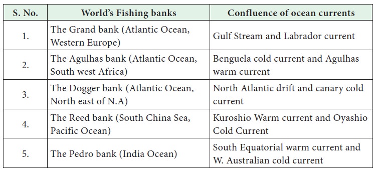
7. It helps in growth of juveniles of certain fish and its distribution to other countries - from its place of origin. Some up welling and down welling are due to currents which bring minerals to photic zone used by phytoplankton. Major fishing grounds are located in the zones where cold current and warm current meet.
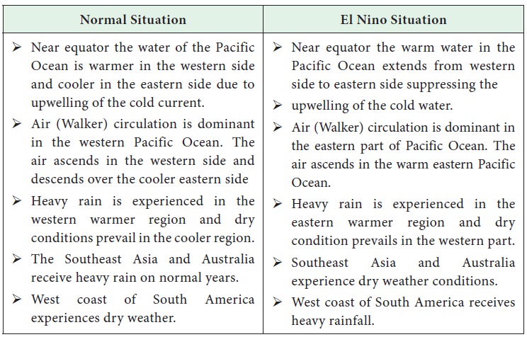
El Nino
El Nino is a phenomenon that occurs in the
equatorial Pacific Ocean characterized by a positive sea surface temperature
departure from normal (1971-2000 base period) in the region lying within the
latitude 5°N to 5°S and longitudes 120° W to 170°W . This phenomenon occurs
every two to seven years (Figure 5.19).
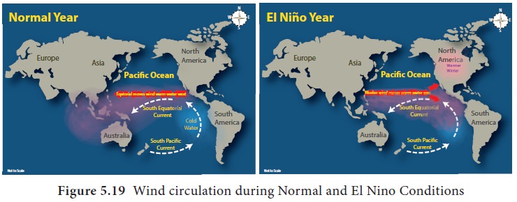
El Nino happens when
·
Sea
surface temperature increases between the central and eastern equatorial
Pacific Ocean between the country Ecuador and the International Date Line
·
The
increase in temperature is sustained for a period of eighteen months to Two
years.
·
The temperature
increase is up to 30 m beneath the ocean surface.
•
When
there is a modified vertical air circulation above the Pacific Ocean
Global influence of El Nino
El Nino effect is experienced at Global level. The
change in air circulation affects the economy of different countries also.
Global weather patterns are altered to such an extent that they affect eco
system, agriculture, tropical cyclone, drought, forest fire, floods and flood
related health hazards. El Nino influences the jet streams. Due to this
phenomenon California experiences heavy rainfall, northern Europe experiences
dry winter, Southern Europe experiences mild wet winters, there are less number
of cyclones in Sea of Japan, and heavy rain in East Africa. South East Asia
experiences severe drought and forest fire. Peru in South America receives
heavy rainfall during El Nino.
Increase of temperature in the east Pacific Ocean
is correlated with normal monsoon conditions in India while the increase of
temperature in the central Pacific has high correlation with drought conditions
in India. When temperature increases further to the west it suppresses the
Indian Monsoon.
La Nina
La Nina is just the opposite to the condition of El
Nino. When trade winds are strong, colder water up wells on the East Pacific
Ocean, walker air circulation is confined to the west Pacific, wet condition in
Southeast Asia and dry weather in South America is observed.
The difference in the atmospheric pressure between
the west and east tropical Southern Pacific Ocean is referred to as Southern
Oscillation. Meteorologists have established a close inter link between
Southern Oscillation and occurrences of El Nino and La Nina events. The acronym
‘ENSO’(El Nino Southern Oscillation) is
often used to study both the
phenomena.
Fact
File
Peruvian
fishermen named the weather phenomenon El Nino meaning ‘little boy’ or ‘New
born Christ’ and La Nina meaning ‘Little girl’ as the phenomenon was first
noticed during Christmas time.
The Sargasso Sea – Sea with landless border
The Sargasso Sea occupies about two thirds of the North Atlantic Ocean, stretching seven hundred miles wide and two thousand miles long. The only “sea” with absolutely no land around it, the Sargasso Sea got its name from common brown seaweed called Sargassum that floats in vast mats in its waters. The Sargasso Sea is surrounded only by ocean currents. It lies within the Northern Atlantic Subtropical Gyre. The Gulf Stream establishes the Sargasso Sea’s western boundary, while the Sea is further defined to the north by the North Atlantic Current, to the east by the Canary Current, and to the south by the North Atlantic Equatorial Current. Since this area is defined by boundary currents, its borders are dynamic.
Related Topics