Hydrosphere | Geography - Maritime zones | 11th Geography : Chapter 5 : Hydrosphere
Chapter: 11th Geography : Chapter 5 : Hydrosphere
Maritime zones
Maritime
zones
The low-tide line forms the base line for marking
maritime zones. Water landward of the
baseline in defined as internal waters over which the state has
complete sovereignty. A country’s territorial sea extends up to 12 nautical miles (22.2 km) from its baseline
(Figure 5.5). The contiguous zone is
a zone of water extending from the outer edge of the territorial sea up to 24
nautical miles (44.4 km) from the baseline.
An Exclusive
Economic Zone (EEZ) extends from the base line to a maximum
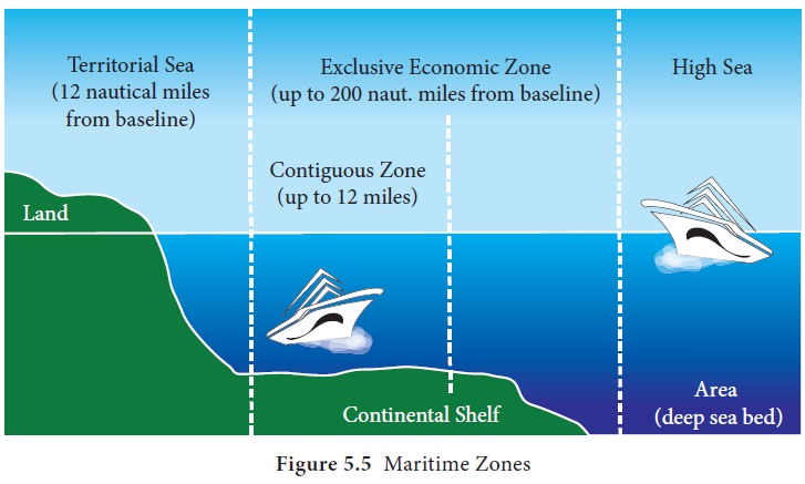
A coastal nation
has control of all economic resources within its exclusive economic zone,
including fishing, mining and oil exploration. Everything beyond EEZ is called International Waters or the High Seas. No nation has sovereign rights
over this area.
Fact
File
A nautical mile is based on the circumference of
the earth, and is equal to one minute of latitude which is equivalent to one
sixtieth of a degree of latitude. A nautical mile is a unit of measurement
defined as 1,852 metres. Nautical miles are used in Navigational charts.
Related Topics