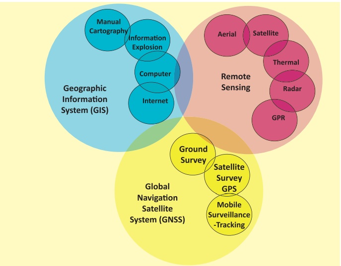
Geoinformatics - Remote sensing | 12th Geography : Chapter 6 : Geoinformatics
Chapter: 12th Geography : Chapter 6 : Geoinformatics
Remote sensing
Remote sensing
Remote sensing is an integrated discipline
encompassing some branches of arts, science and technology of collecting information
about the terrestrial objects using camera and sensor system.
Elements of Remote Sensing
1. Energy Source
The primary requirement for remote sensing
is to have an energy service, which provides electromagnetic energy to the target
of interest. The sun being a major source of energy, radiation and illumination
having a sharp power allows capturing reflected light with conventional cameras
and films.
2. Radiation and the Atmosphere
The energy is required to illuminate
the target. This energy is in the form of Electromagnetic radiation. Electromagnetic
radiation is a dynamic form of energy that propagates as wave motion at a velocity
in space.
3. Interaction with the target
The interaction of Electromagnetic radiation with the target is important to remote sensing for two main reasons. First, information carried Electromagnetic radiation reflected by the earth’s surface is modified while traversing through the atmosphere. Second, the interaction of Electromagnetic radiation with the atmosphere can be used to obtain useful information about the atmosphere itself. The total energy is subjected to modification by the several physical process, scattering, absorption and refraction. Scattering is the re-direction of Electromagnetic radiation by particles suspended in the atmosphere or by large molecules of atmospheric gases. The amount of scattering depends upon the size of the particles and their abundance. The wave length of radiation, depth of the atmosphere through which the energy is travelling. Absorption is the process by which the gas molecules present in the atmosphere strongly absorb the Electromagnetic radiation through the atmosphere in certain spectral bands.
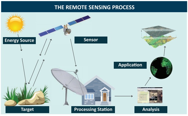
4. Recording of energy by the sensor
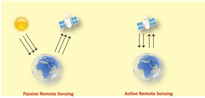
After the energy has been scattered by or emitted from the target, we require a sensor (remote not in contact with the target) to collect and record the electromagnetic radiation. A sensor is highly sensitive to all the wave lengths yielding spatially detailed data on absolute brightness. On the basis of the source of electromagnetic energy, the sensor can be classified into two ways. They are active sensor or passive sensor. Active sensor generates and uses its own energy to illuminate the target and records the reflected energy. It operates in the microwave regions of the electromagnetic spectrum. Their wave lengths are longer than 1 mm.
5. Transmission, Reception and Processing
The energy
recorded by the sensor has to be transmitted in electronic form, to a receiving
and processing station where the data processed into an image. The Image processing
methods may be grouped into three functional categories such as Image Restoration,
Image Enhancement and Information Extraction.
Image Restoration: Restoration processes are designed to recognize and compensate
for errors, noise and geometric distortion introduced into the data during the scanning
transmission and recording processes. The objective is to make the image resemble
the original scene. Image restoration is relatively simple because the pixels from
each band are processed separately.
Image
Enhancement: Enhancement
is the modification of an image, to alter
its impact on viewer. General enhancement distorts the original digital values;
therefore enhancement is not done until the restoration processes are completed.
Information
extraction: Image restoration and enhancement process utilize computers
to provide corrected and improved images for study by human interpreters. The computer
makes no decision in these procedures. The human operator must instruct the computer
and must evaluate the significance of the extracted information.
6. Interpretation and Analysis Image interpretation is defined as the
act of examining images to identify objects and judge their significance. An interpreter
studies remotely sensed data and attempts through logical process to detect, identify,
measure and evaluate the significance of environment and cultural object pattern
and spatial relationship.
The quality
of an image is based on the inherent characteristics of the objects. Further it
depends on the following aspects.
* Sensor
characteristics
* Season
of the year, time of the day when the photo is taken
* Atmospheric
effects
* Resolution
of the image
* Image motion
etc
Image interpretation
is essential for the efficient and effective use of the data. The elements of image
interpretation such as image tone, shape, size, pattern, image texture, shadow and
association are helpful to identify the exact target and to analyse.
Classification of remote sensing
On the basis of the sources of electromagnetic
energy, the remote sensing can be classified as passive and active remote sensing.
In a simple way, we can understand that the passive remote sensing is similar to
taking a picture with an ordinary camera where as active remote sensing is analogous
to taking picture with camera having built-in flash.
On the basis of the energy source, the
active remote sensing generates and uses its own energy to illuminate the target
and records the reflected energy where as the passive remote sensing depend on solar
radiation to illuminate the target. On the basis of region of spectrum in which
they operate, the active remote sensing operate in the microwave region of the electromagnetic
spectrum where as the passive remote sensing operate in the visible and infrared
region of the electromagnetic spectrum. The wave lengths of the active remote sensing
are longer than 1 where as the passive remote sensing, the wave length range from
0.4 to 1.0 mm.
Some examples
of active sensors are Fluorosensor and Synthetic Aperture Radar (SAR). Passive sensors
record radiation reflected from the earth's surface. The source of this radiation
must come from outside the sensor; in most cases, this is solar energy. Because
of this energy requirement, passive solar sensors can only capture data during daylight
hours. Active sensors are different from
passive sensors. Unlike passive sensors, active sensors require the energy source
to come from within the sensor. A laser-beam remote sensing system is an active
sensor that sends out a beam of light with a known wavelength and frequency. This
beam of light hits the earth and is reflected back to the sensor, which records
the time it took for the beam of light to return.
Remote sensing platform
The platform
is a stage to mount the camera or sensor to acquire the information about a target
under investigation. Based on the altitude above the earth surface, the platform
can be classified as Ground borne platform, Air borne platform and Space borne platform.
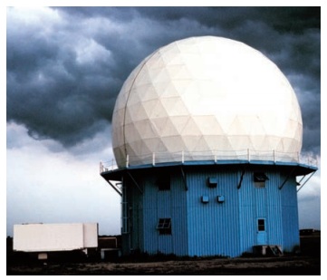
Ground borne platform
Ground based
platforms sensors may be placed on a ladder, scaffolding tall-building, crane etc.
These are used to record detailed information about the surface which is compared
with information collected from aircraft or satellite sensors. They are close to
the ground.
A wide variety of ground based platforms
are used in remote sensing. Some of the more common ones are hand held devices,
tripods, towers and cranes. Instruments that are ground-based are often used to
measure the quantity and quality of light coming from the sun or for close range
characterization of objects Permanent ground platforms are typically used for monitoring
atmospheric phenomenon although they are also used for long-term monitoring of terrestrial
features.
Air borne platform
Aircrafts
are generally used to acquire aerial photographs for photo interpretation and photogrammetric
purposes. They are classified into two types. They are
* Low altitude aerial
remote sensing
* High altitude
aerial remote sensing
Balloon
Balloons
are used for remote sensing observation (aerial photography) and nature conservation
studies. The first aerial images were acquired with a camera carried aloft by a
balloon in 1859. Balloon floats at a constant height of about 30 km.
Drone
Drone is a miniature remotely piloted
aircraft. It is designed to fulfil requirements for a low cost platform, with long
endurance, moderate payload capacity and capability to operate without a runway
or small runway. Drone includes equipment of photography, infrared detection, radar
observation and TV surveillance. It uses satellite communication link. An onboard
computer controls the payload and stores data from different sensors and instruments.
The unique advantage is that it could be accurately located above the area for which
data was required and capable to provide both night and day data.
Aircraft
The first
known aerial photograph was taken in 1858 by French photographer and balloonist,
Gaspar Felix Tournachon, known as "Nadar". In 1855 Special aircraft with
cameras and sensors on vibration less platforms are traditionally used to acquire
aerial photographs and images of land surface features. While low altitude aerial
photography results in large scale images providing detailed information on the
terrain, the high altitude smaller scale images offer advantage to cover a larger
study area with low spatial resolution.
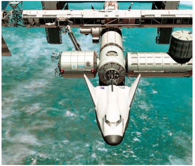
Space borne platform
The satellites
are normally used for the space borne remote sensing. The satellite moves in their
orbit. The closed path of a satellite around the earth is called its orbit. These
platforms are freely moving in their orbit around the earth and the entire earth
or any part of the earth can be covered at specified intervals. The coverage mainly
depends on the orbit of the satellite. It is through these space borne platforms,
we get the enormous amount of remote sensing data. In space borne remote sensing,
sensors are mounted on-board a spacecraft (space shuttle or satellite) orbiting
the earth. Space borne remote sensing provides the following advantages:
1. Large area coverage.
2. Frequent and repetitive
coverage of an area of interest.
3. Quantitative measurement
of ground features using radio metrically calibrated sensors.
4. Semi automated computerised
processing and analysis.
5. Relatively
lower cost per unit area of coverage.
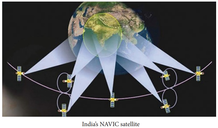
Types of satellite
Satellite
orbits are designed according to the capacity and objective of the sensors they
carry. Depending on their altitude, orientation and rotation relative to the earth
satellites can be categorized as
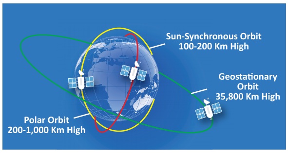
1. Geostationary satellite
2. Polar Orbiting or
Sun-Synchronous satellite
3. Spy satellite
1. Geostationary Satellites
Geostationary
Satellite is an equatorial west to east satellite orbiting the earth at an altitude
of 35000 km, the altitude at which it makes on revolution in 24 hours. These platforms
are covering the same place and give continuous near hemispheric coverage over the
same area day and night. These satellites are put in equatorial plane orbiting from
west to east. Its coverage is limited to 70°N to 70°S latitudes and one satellite
can view one-third globe. These are mainly used for communication and meteorological
applications viz. GOES, METEOSAT, INTELSAT, and INSAT satellites. On June 19, 1981
India launched its first geostationary satellite called APPLE. It was an experimental
communication satellite launched by the Indian Space Research Organisation (ISRO).
APPLE being tested on a bullock cart
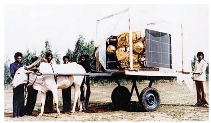
The Ariane
Passenger Payload Experiment (APPLE) was ISRO's first indigenous, experimental communication
satellite.
India is the only one country
which has reached to the mars in its first attempt.
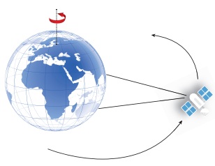
2. Polar Orbiting or Sun-Synchronous satellite
As the satellite
orbits the Earth from pole to pole, its east-west position would not change if the
Earth did not rotate. However, as seen from the Earth, it seems that the satellite
is shifting westward because the Earth is rotating (from west to east) beneath it.
This apparent movement allows the satellite swath to cover a new area with each
pass. All the remote sensing resource satellites may be grouped in this category.
Few of these satellites are LANDSAT series, SPOT series, IRS series, NOAA SEASAT,
TIROS, HCMM, SKYLAB, and SPACE SHUTTLE etc.
3. Spy satellites
Spy satellites are observational platforms that orbit the Earth in order to image its surface and to record radio signals for military and political purposes. They transmit their data to Earth, where it is interpreted by specialists in centralised, secretive facilities such as the U.S. National Photographic Interpretation Centre in Washington, D.C. Spy satellites have been essential not only to military operations and the formation of national policy but to the verification of arms control treaties such as SALT I, SALT II, etc.
The four basic types of spy satellite
are: (1) photo reconnaissance systems that take pictures in visible and infrared
light, (2) infrared telescopes designed to detect missile launches, (3) radars that
image sea or land even through cloud cover and in darkness, and (4) signals intelligence
(SIGINT) satellites (also termed "ferrets"), which are optimised either
for characterising ground-based radar systems or for eavesdropping on communications.
Sometimes photo reconnaissance and SIGINT functions are combined in single, massive
platforms such as the U.S. Keyhole-series satellites.
Although a number of nations have launched
spy satellites, the U.S. and the Soviet Union are responsible for by far the greatest
number. The Russian Federation, which inherited most of the Soviet Union's space
system after 1991, has been unable to afford the cost of adequately updating its
spy satellite network. In contrast, the U.S. has continued to deploy ever-more-sophisticated
systems in a steady stream. Thus, the majority of spy satellites in orbit today,
including all the most capable units, are U.S.-owned. Early U.S. Spy Satellites:
Corona, MIDAS, SAMOS.
The Gaofen 4 is the world's
most powerful GEO spy satellite (launched in 2015) which can provide instant coverage
of earthquake or typhoon hit areas to support humanitarian relief. It will also
allow China to monitor strategic foreign sites such as WMD facilities and naval
bases inside its observation box.
Applications of remote sensing
1. Agriculture
The satellites have ability to image
individual fields, regions and countries on a frequent revisit cycle. Customers
can receive field-based information including crop identification, crop area determination
and crop condition monitoring (health and viability). Satellite data are employed
in precision agriculture to manage and monitor farming practices at different levels.
2. Forest Management
The forest - fire, sudden deforestation,
encroachment of forest- land are recent challenges to the ecologist. It can be easily
identified and curbed with the help of remote sensing satellite pictures.
3. Geology
Various fields
Remote sensing techniques used in geology are
* Lithological mapping
* Structural
mapping
* Geomorphological
mapping
* Mineral
exploration
* Hydrocarbon
exploration
* Sedimentationmapping
and monitoring
* Geo-hazard
mapping
CASE STUDY
NASA launches world's lightest
satellite designed by 18-year-old Tamil Nadu student.
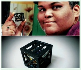
India once again broke a global space record by launching the world's
lightest satellite weighing a mere 64 grams, called Kalamsat. It was designed and
developed not by professional space scientists and engineers, but by 18-year-old
Tamil Nadu student Rifath Sharook and his team. The tiny satellite, named after
Abdul Kalam, was flown by a NASA sounding rocket on 22 June, 2017 and Kalamsat was
the only Indian payload in the mission. Mission director Srimathy Kesan that the
total flight time of the rocket was 240 minutes. The satellite, assembled at her
T.Nagar residence in Chennai. The satellite was separated from the rocket after
spending 125 minutes in the space's micro-gravity environment. Sharook’s project,
the first to be manufactured via 3D printing, got selected through a competition,
‘Cubes in Space', sponsored jointly by NASA and 'I Doodle Learning'. The project
aims to take the performance of new technology to space.
4. Oceanography
Satellite remote sensing plays an important role in coastal zone management. It allows us to locate and regularly monitor various aspects such as bathymetry (the measurement of the depth of water in water bodies), chlorophyll content, suspended sediment concentration, etc.
5. Cartography
Remote sensing
aids in extensive surveys that are made from high altitudes to show the urban development,
rural development, mountain areas, deserts, etc which help the cartographers. High-resolution
satellite cameras located at altitudes of several hundred kilometres can record
details as small as a few metres on the surface of the Earth.
6. Meteorology
The radar
system is basically used to collect the weather data. It collects meteorological
data from unmanned land/ ocean based Data collection platforms and serves as a communication
satellite for rapid exchange of meteorological data among centres and for rapid
dissemination of weather forecasts warnings etc, to user agencies.
7. Topography
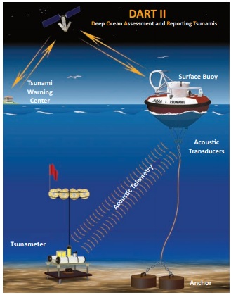
Topography specifically involves the recording of relief or terrain, the three-dimensional quality of the surface, and Acousc Telemetry Tsunameter Anchor the identification of specific landforms. Topographic maps usually portray both natural and manmade features. They show and name works of nature including mountains, valleys, plains, lakes, rivers, and vegetation. They also identify the principal works of man, such as roads, boundaries, transmission lines, and major buildings.
8. Urban Planning
These information
systems also offer interpretation of physical (spatial) data with other socio- economic
data, and thereby providing an important linkage in the total planning process and
making it more effective and meaningful. Digitization of planning base maps has
facilitated updating of base maps wherever changes have taken place in terms of
land development etc. Superimposition of any two digital maps which are on two different
scales is feasible.
Related Topics