Applications of GNSS, System operated in different countries - Global Navigation Satellite System (GNSS) | 12th Geography : Chapter 6 : Geoinformatics
Chapter: 12th Geography : Chapter 6 : Geoinformatics
Global Navigation Satellite System (GNSS)
Global Navigation Satellite
System (GNSS)
GNSS refers to the collection of the
world's global satellite based positioning systems. It includes GPS (United States)
GLONASS (Russia) GALILEO (European Union) BEODOU (China) IRNSS (India) QZSS (Japan).
GNSS can provide centimetre level accuracy with a low-cost receiver, if an error
correction technique is used. GNSS are recognized to be the systems of choice in
outdoor environments and, to a great extent, GNSS bi static radar with the GPS satellite
one of the most accurate source of position (and precise timing) information when
it is available.
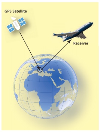
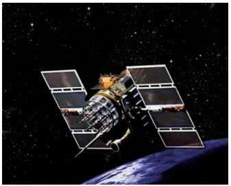
The first satellite navigation system was Transit, a system deployed by the US military in 1960’s. Transit’s operations were based on the Doppler Effect: the satellites travelled on well-known paths and broadcast their signals on well-known radio frequency. The received frequency will differ slightly from the broadcast frequency because of the movement of the satellite with respect to the receiver. The satellite broad cast signals that contains orbital data (from which the position of the satellite can be calculated) and the precise time, the signals is transmitted. There are multiple constellations of GNSS satellites orbiting the earth. GNSS satellites’ orbit situated about 20,000 km above the earth’s surface. They are moving very fast, several kilometres per second. The latest generation of GNSS satellites (Block IIF) weight over 1,400 kg.
GNSS system operated in different countries
The following are the Global Navigation
satellite Systems:
GPS (United States)
GPS was the first GNSS system. GPS was
launched in the late 1970s by the United States Department of Defence. It uses a
constellation of 24 satellites, and provides global coverage.
GLONASS (Russia)
The premier Soviet military navigation network was to be comprised of Uragan satellites. At the end of the Cold War, the constellation was unclassified under the name GLONASS -- a Russian abbreviation of Global Navigation Satellite System. Global Navigation Satellite System by Russian Aerospace Defence Forces is a space-based satellite navigation system.
The life style of GNSS satellites 5-
7 years and new satellites are to be launched after a specific time interval in
order to fill the gap due to ageing satellites. GLONASS proves very beneficial for
Russian territory by 2010. In 2011, restoration of system is improved to enable
full global coverage.
GALILEO (European Union)
Galileo is Europe’s own global navigation
satellite system, providing a highly accurate, guaranteed global positioning service
under civilian control. Currently providing Initial Services, Galileo is interoperable
with GPS and Glonass, the US and Russian global satellite navigation systems. By
offering dual frequency as standard, Galileo is set to deliver real-time positioning
accuracy down to the metre range. The Galileo constellation in space will comprise
30 satellites in total. There will be 24 operational satellites, plus 6 spare satellites,
circulating in medium Earth orbit on three orbital planes.
BEIDOU (China)
BeiDou
Navigation Satellite System (BDS) is
a Chinese satellite Navigation system.
It consists of two separate satellite constellations. The first BeiDou system is
officially called the BeiDou Satellite Navigation Experimental System and also known
as BeiDou-1.
On December 27, 2018, Beidou-3 officially
began to provide global services. The Beidou-3M/G/I satellites represent the orbital
segment of the third phase of the Chinese Beidou navigation system which uses satellites
in Medium Earth Orbit and Geosynchronous Orbit and is also known as the Compass
Navigation Satellite System.
Japan Aerospace Exploration Agency (QZSS Japan)
QZSS is a regional navigation satellite system that provides service to Japan and the Asia-Oceania region. QZSS (nickname of Michibiki - meaning to 'guide' or 'show the way') QZSS is a Japanese satellite positioning system composed mainly of satellites in quasi-zenith orbits (QZO). However, the term “Quasi-Zenith Satellite (QZS)” can refer to both satellites in QZO and geostationary orbits (GEO). For that reason, the name “QZO satellite” is used when it is necessary to specifically refer to satellites in QZO. Satellite positioning systems use satellite signals to calculate position information. The QZSS is sometimes called the “Japanese GPS.”
IRNSS (Indian Regional Navigational Satellite System)
IRNSS is an autonomous regional satellite
navigation system being developed by ISRO (Indian Space Research Organization).
It is designed to provide geospatial positioning information within the Indian sub-continent.
It enables users to map out their location (altitude, longitude and latitude). The
objective of developing IRNSS was to cut down India's dependency on foreign navigation
satellite systems.
It provides location information service
to users in India and the region extending for up to 1,500 km from the Indian boundary.
This is the primary service area of IRNSS information service to users in India
and the region extending up to 1500 km from Indian boundary.
IRNSS aims to provide the following services:
1. Standard Positioning
Service (SPS) for civilian, research & commercial use,
2. Restricted Service (RS) for authorized
users. For example in defence, IRNSS is used for ground, aerial and marine navigation,
disaster management, mobile phone integration, mapping and visual & voice navigation
for drivers, among others.
Fact File
The battle for the world’s fastest supercomputer has a new victor:
Summit

According to IBM, Summit
is able to achieve 200 peta flops of performance, or 200 quadrillion calculations
per second. This power marks a significant gain on Sunway TaihuLight, which performs
a still-staggering 87 petaflops. Summit holds more than 10 peta bytes of RAM, and
its funding came as part of a $325 million program funded by the United States Department
of Energy. Each of Summit’s 4,608 nodes holds two IBM Power9 chips that run at 3.1
GHz.
Applications of GNSS
GNSS applications are widely used to
get the quick information about a particular field. Some of the commercial applications
are Consumers, Transportation, GIS, Machine Control Port Automation, Precision Agriculture,
Construction, Marine Mining, Unmanned Vehicles Surveying, Defence, and Aerial Photogrammetry,
etc.
Consumer
GNSS technology has been adopted by the
consumer market, in an ever-increasing range of products. GNSS receivers are now
routinely integrated into smart phones, to support applications that display maps
showing the location of and best route to stores and restaurants.
Transportation
In rail transportation, GNSS is used
to track the location of locomotives and rail cars, maintenance vehicles and wayside
equipment, for display at central monitoring consoles. Knowing the precise location
of rail equipment reduces accidents, delays, and operating costs, enhancing safety,
track capacity, and customer service. In aviation, GNSS is being used for aircraft
navigation from departure, en route, to landing.
Port
Automation
Using GNSS, shipping hubs can improve
their operating efficiency by tracking the movement and placement of containers
about their yards. Many cranes are equipped with GNSS based steering devices that
determine the crane’s position and keep it travelling in the desired path, improving
accuracy and productivity as well as the safety of operators and workers on the
ground.

Machine
Control
GNSS technology is being integrated into
equipment such as bulldozers, excavators, graders, pavers and farm machinery to
enhance productivity in the real-time operation of this equipment, and to provide
situational awareness information to the equipment operator.

Precision
Agriculture
In precision agriculture, GNSS-based
applications are used to support farm planning, field mapping, soil sampling, tractor
guidance, and crop assessment. More precise application of fertilizers, pesticides
and herbicides reduces cost and environmental impact.
Surface
Mining
GNSS information is being used to efficiently
manage the mining of an ore body and the movement of waste material. GNSS equipment
installed on shovels and haul trucks provides position information to a computer-controlled
dispatch system to optimally route haul trucks to and from each shovel.
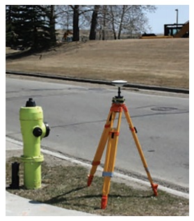
Survey
Using GNSS, it is possible for a single
surveyor to accomplish in one day what might have taken a survey crew of three people
a week to complete. Determining a new survey position once required measuring distances
and bearings from an existing (known) survey point to the new point.
Related Topics