Importance,Specific uses - Geographic Information System (GIS) | 12th Botany : Chapter 8 : Environmental Issues
Chapter: 12th Botany : Chapter 8 : Environmental Issues
Geographic Information System (GIS)
Geographic Information System
GIS is a computer system for capturing, storing, checking and
displaying data related to positions on Earth’s surface. Also to manipulate,
analyse, manage and present spacial or geographic data.
GPS is a satellite navigation system used to determine the ground
position of an object. It is a constellation of approximately 30 well
spaced satellites that orbit the earth and make it possible for the people with
ground receivers to pinpoint their geographic location. Some applications in
which GPS is currently being used for around the world include Mining,
Aviation, Surveying Agricultural and Marine ecosystem.
Importance of GIS
·
Environmental impact assessment
·
Disaster management
·
Zoning of landslide hazard
·
Determination of land cover and land use
·
Estimation of flood damage
·
Management of natural resources
·
Soil mapping
·
Wetland mapping
·
Irrigation management and identification of volcanic hazard
·
Vegetation studies and mapping of threatened and endemic species.
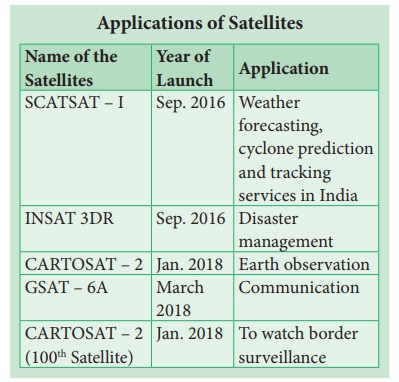
Remote Sensing is the process of detecting and
monitoring the physical characteristics of an area by measuring its reflected
and emitted radiation at a distance from the targeted area. It is an tool used
in conservation practices by giving exact picture and data on identification of
even a single tree to large area of vegetation and wild life for classification
of land use patterns and studies, identification of biodiversity rich or less
areas for futuristic works on conservation and maintenance of various species
including commercial crop, medicinal plants and threatened plants.
Specific uses
·
Helps predicting favourable climate, for the study of spreading of
disease and controlling it.
·
Mapping of forest fire and species distribution.
·
Tracking the patterns of urban area development and the changes in
Farmland or forests over several years
·
Mapping ocean bottom and its resources

Related Topics