Geography - Drainage/Rivers of Tamil Nadu | 10th Social Science : Geography : Chapter 7 : Physical Geography of Tamil Nadu
Chapter: 10th Social Science : Geography : Chapter 7 : Physical Geography of Tamil Nadu
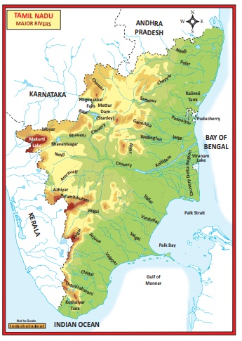
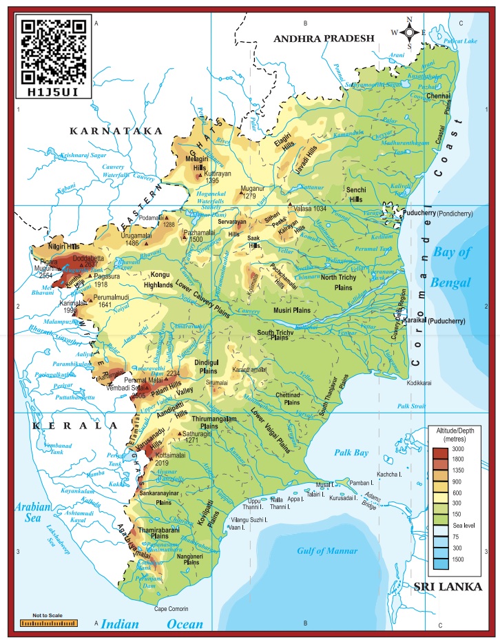
Drainage/Rivers of Tamil Nadu
Drainage
Rivers of
Tamil Nadu are its lifeline. Though it has many rivers, the rivers of Cauvery,
Palar, Ponnaiyar, Vaigai and Thamirabarani are the notable ones. Most of the
rivers of Tamil Nadu originate from Western Ghats and flow towards east and
drain into the Bay of Bengal. All the rivers of the state are non- perennial
except Thamirabarani. It is perennial as it is fed by both the southwest and
northeast monsoons.
Cauvery
The river
Cauvery originates at Talacauvery in the Brahmagiri hills of Kodagu(coorg)
district of Karnataka in the Western Ghats. Total length of Cauvery river is
805 km. About 416 km of its course falls in Tamil Nadu. It serves as the
boundary between Karnataka and Tamil Nadu for a distance of 64 km. It forms
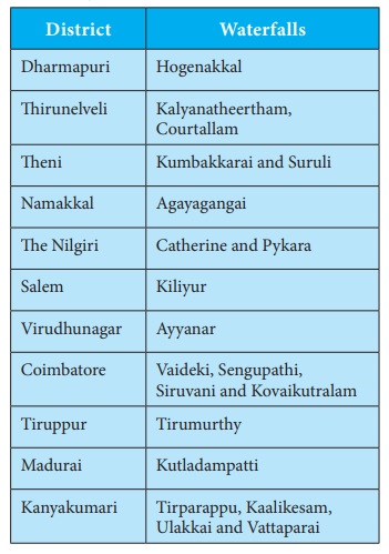
Hogenakkal waterfalls in Dharmapuri district. Mettur Dam, also called as the
Stanley Reservoir, is located across this river in Salem district. A tributary
called Bhavani joins Cauvery on the right bank about 45 km from the Mettur
Reservoir. Thereafter, it takes easterly course to enter into the plains of
Tamil Nadu. Two more tributaries, Noyyal and Amaravathi, confluence the river
on the right bank at Thirumukkudal 10 km from Karur. The river is wider in this
region, where it is called as ‘Agandra Cauvery’.
In
Tiruchirappalli district, the river branches into two parts. The northern
branch is called Coleroon or Kollidam and the southern branch remains Cauvery.
From here, the Cauvery delta begins. After flowing for about 16 km, the two
branches join again to form the ‘Srirangam
Island’. The Grand Anaicut, also called as Kallanai was built across the
river Cauvery. After Kallanai, the river breaks into a large number of
distributaries and forms a network all over the delta. The network of
distributaries within the delta of Cauvery in the coast is called as the ‘ Garden of Southern India ’. It merges into Bay of Bengal to the south of Cuddalore.
Pamban, Hare, Krusadai, Nallathanni
Theevu, Pullivasal, Srirangam, Upputanni, Island Grounds, Kattupalli Island, Quibble
Island and Vivekananda Rock Memorial are some major islands of Tamil Nadu
Palar
The Palar
river rises beyond Talagavara village in the Kolar district of Karnataka. The
Palar drains an area of 17,871 sq.km, out of which nearly 57% lies in Tamil
Nadu and the rest in the states of Karnataka and Andhra Pradesh. Ponnai,
Goundinya Nadhi, Malattar, Cheyyar and Kiliyar are its major tributaries. Its
total length is 348 km, out of which 222 km of its course falls in Tamil Nadu.
It flows through the districts of Vellore and Kancheepuram before entering into
Bay of Bengal near Kuvattur.
Then Pennaiyar/Then Ponnaiyar
It
originates from the eastern slope of Nandi Durga hills in eastern Karnataka. It
drains an area of 16,019 sq.km, of which nearly 77% lies in Tamil Nadu. It
flows for a distance of 247 km in the southeasterly direction in the districts
of Krishnagiri, Dharmapuri, Vellore, Tiruvannamalai, Cuddalore and Villupuram.
It branches into two, viz. Gadilam and the Ponnaiyar near Tirukoilur Anaicut.
Gadilam joins the Bay of Bengal near Cuddalore and Ponnaiyar near the Union
Territory of Puducherry. Chinnar, Markandanadhi, Vaniar and Pambar are its
tributaries. Heavy rain at the river’s source cause sudden but short-lived
floods. The river is extensively dammed for irrigation, especially in Tamil
Nadu. There are reservoirs at Krishnagiri and Sathanur across this river. The Ponnaiyar is considered sacred by
Hindus and festivals are held during the Tamil month of Thai (January–
February).
Vaigai
Vaigai
river rises from the eastern slopes of the Varusanadu hills of Western Ghats of
Tamil Nadu. It drains an area of 7,741 sq.km, which lies entirely in the state
of Tamil Nadu. It flows through the districts of Madurai, Sivaganga and
Ramanathapuram. Its length is 258 km. It discharges its water into the Ramnad
Big Tank and some other small tanks. The surplus water from the tanks is
finally discharged into Palk Strait near Ramanathapuram..
Thamirabarani
The name
is interpreted as Thamiram (copper) and Varuni (streams of river). The water of
this river gives a copper like appearance due to the presence of dissolved
suspended red soil. It originates from a peak in Pothigai hills on the Western
Ghats above Papanasam in the Ambasamudram taluk. The origin of the river is
associated with Sage Agasthiyar. It courses through the districts of
Tirunelveli and Thoothukudi and finally flow into the Bay of Bangal near
Punnaikayal in Thoothukudi district. Karaiyar, Servalar, Manimuthar,
Gadananathi, Pachaiyar, Chittar and Ramanathi are its main tributaries. It is
the only perennial river in South India.
Related Topics