Example of Time Calculations, Longitude Calculations Procedures | Geography - Time Zones of the World | 11th Geography : Chapter 2 : The Solar system and the Earth
Chapter: 11th Geography : Chapter 2 : The Solar system and the Earth
Time Zones of the World
Time
Zones of the World
People during the medieval period were using
sundials and water clocks to observe the Sun’s meridian passing at noon. In 17th
century, the people started using pendulum clock which did not show accurate
time while travelling in the sea. Later chronometer was invented in 1764.
Chronometer measures time accurately and the mariners widely used this during
the 19th century. But in many towns and cities clocks were set based
on sunset and sunrise. The use of local solar time hindered the development of
railways and telecommunications. A time zone is a region on the earth where
uniform standard time should be maintained for transport, commercial and social
purposes. For example, if different time zones were followed, the trains coming
from different regions, sharing single track may meet with accidents.
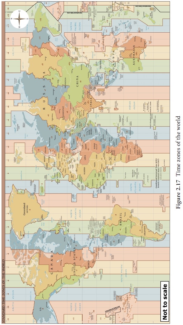
The world time zone (Figure 2.17) was formed,
relating longitude and the rotation of the earth. The Prime Meridian is the
centre of time zone extending from 7½ºW and 7½ º E longitudes. The 24 hours
time zone system had been developed so that all the time zones should be
referred with respect to Greenwich Mean Time. Earth was divided into 24 time
zones, each one zone for one hour of the day. It is because earth rotates 15º
of longitude in one hour (360º divided by 24 hours). The time when solar noon
occurs at the Prime Meridian is fixed as noon for all places between 7½º E and
7½º W.
Daylight
Saving Time
In the mid latitude countries of Europe, North
America, Australia and South America, the day time are longer in summer than
the night. In spite of employing daylight duration, the clocks are adjusted 1
hour forward in spring and 1 hour backward in autumn. This time is generally
known as ‘the Daylight Saving Time’ (DST).
Time Zones
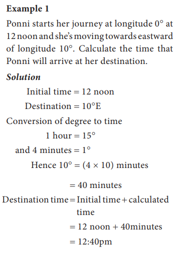
On its axis, the earth rotates 360 degrees every 24
hours. You can look at it as it takes one day to complete a full circle.
Divided up into an hourly rate, the earth rotates 15 degrees every hour
(360/24). This number plays an important role in determining time zones. You
have already learned about the latitudes and longitudes and their importance in
the lower classes.
An important factor in determining time zones is
the lines of latitude and longitude, imaginary lines known as latitudes and
longitudes dividing the earth. Latitude lines are drawn east - west and they
measure the location in northern and southern hemisphere. The line starts at
the equator and measure distance from 0 degrees to 90 degrees north and also 0
degrees to 90 degrees south. They also become shorter farther away from the
equator. On the other hand, longitude lines are drawn north - south and they
measure eastern and western hemisphere. They start at the Prime Meridian (or 0
degree) and measure from 0 degrees to 180 degrees east and 180 degrees west.
Unlike lines of latitude, these lines are fairly equal in length. The origin of
this spherical coordinate system is at 0 degree latitude and 0 degree
longitude. This spot can be found in the Atlantic Ocean just south west of
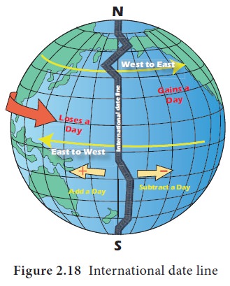
Africa. Also, the two lines connect at 180 degrees or at the International Date
Line (Figure 2.18). This too helps to determining different time zones of the
world.
Together all of the above information can be used
to calculate the difference of time between two locations.
1.
First,
we need to know what longitudes the two places are located.
2.
Next,
you would need to find the differences in longitude (in degrees) between the
two places. If both places are located on the same side of the Prime Meridian,
then the numbers are just simply subtracted to find the difference. If they are
on the opposite side of the Prime Meridian then the two numbers should be added
together to find the difference.
3.
Third,
we need to divide the difference (measured in degrees) by 15 since there are 15
degrees in every hour. This will give us the difference in time between the two
locations. So if you know what time it is in one location, and the longitude of
another location, then just simple addition or subtraction problem will give us
the time in a different time zone. Let's look at another way we may have to
calculate the difference between times of two locations.
Another calculation you may have to make is over
the International Date Line. This line is strategically placed in the Pacific
Ocean so that no two neighboring cities are one day apart in time. It can be
difficult to calculate though the International Date Line when trying to
determine the amount of time difference between locations on either side. This
calculation is very similar to the situation with the Prime Meridian. We must
start by finding the difference in longitude (or degrees) of the two places. We
do this by adding the two numbers. Then, divide by the 15 degrees that occurs
in one hour and this will give you the time difference between two locations
through the International Date Line. And again, just add or subtract that difference
from the time that we already know to come up with the new time in the new time
zone.
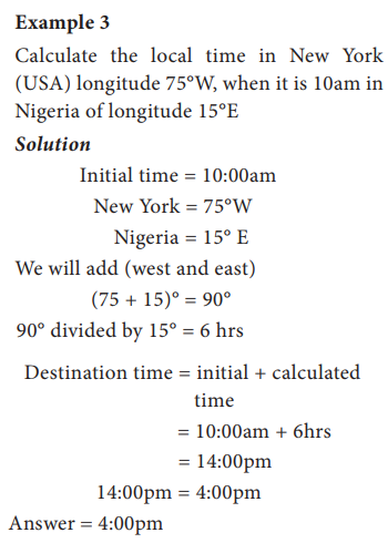
Example of Time Calculations
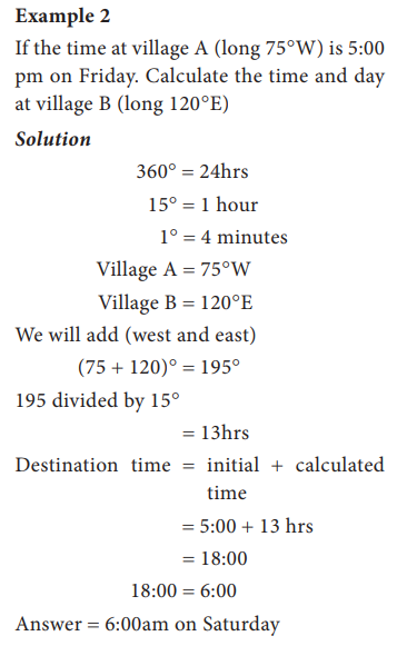
To review, to find the difference between the two longitudes and divide by 15, this
gives you the difference in hours between the two locations. Second, add or
subtract the number of hours from the time of day that was already known, we
will need to add the numbers if we are going east, and subtract if we are going
west. Here are some examples of how we may need to calculate the difference of
time zones.
If you are in London at 12:00, and want to know
what time it is in Japan, you would need to first figure out that London is 0
degrees (right on the prime meridian), and Japan is 135 degrees East. So the
difference is 135 degrees (135–0), divided by 15 which equals 9. It means there
is a 9-hour difference between London and Japan. Since Japan is further east
than London is, you would add 9 hours to 12:00. The answer is at 12:00 noon
London time, it is 9:00pm in Japan.
Now we suppose imagine that we are going through
the International Date Line. Pretend you are in Japan, which is 135 degrees
east and you wanted to know what time it is in Hawaii, which is 150 West. Well,
there is 45 (180–135) degrees difference between Japan and the IDL. Also there
is 30 (180–150) degrees difference between the IDL and Hawaii. Therefore the
difference in time is (45 30/15 5) 5 hours. Now the tricky part is that Japan
and Hawaii are on different days. It is one day ahead on the left side of the
IDL compared to the right side. If it is 3:00pm in Japan on Thursday that means
it is 3:00 5 hours 8:00pm in Hawaii. However notice that when crossing the IDL
we subtract a day going east. So, in Hawaii it is 8:00pm on Wednesday.
Now note that Latitudinal lines are imaginary
horizontal lines over the Earth's globe. 0q longitudinal line is Equator. Earth
completes one rotation on its axis in 24 hours and in the process turns a
complete circle of 360q. This means Earth rotates 360q/24 15q in one hour.
Every gain or loss of 1q longitude stands for 4 minutes.
360q 24 hours 1440 min Difference of time for
15q longitude one hour.
Difference of time for 1q longitude 4
minutes.
Longitude Calculations Procedures
a.
First
locate the two places involved
b.
find
the longitude difference
c.
Convert
the longitude difference to time and,
d.
Adjust
the time according to the direction of movement, (west or east).
Related Topics