Mapping Skills | Geography | Social Science - Answer in Paragraph | 9th Social Science : Geography: Mapping Skills
Chapter: 9th Social Science : Geography: Mapping Skills
Answer in Paragraph
MAPPING SKILLS
VII. Answer in
Paragraph
1. What do you mean by the term
'scale of the map'? Explain its classification.
Scale:
• Scale makes it possible to reduce the size of the whole earth
to show it on a piece of paper.
• A scale is a ratio between the actual distance on the map to
the actual distance on the ground.
• Scales can be represented in three methods. They are the
Statement, Representative Fraction (R.F) and Linear or Graphical scale methods.
Statement scale:
• The statement scale describes the relationship of map distance
to ground distance in words, such as one centimetre to ten kilometres. It is
expressed as 1cm = 10 km.
The Representative
Fraction (R.F):
• It describes the proportion or ratio of the map distance to
ground distance. It is usually abbreviated as R.F. It is stated as 1/100000
(or) 1:100000.
Representative Fraction (R.F.) = Distance on the map / Distance on the ground
Linear (or)
Graphical scale :
• In a map, a linear scale is represented by a straight line
divided into equal parts (primary and secondary) to show what these markings
represent on the actual ground.
• This scale helps in the direct measurement of distance on the
map.
2. Write a note on directions
with relevant diagram.
Direction
• Maps are drawn normally with north orientation. North direction
in a map is always towards the North Pole of the earth.
• lf you position yourself looking at the North Pole, on your
right will be the east; your left will be the west; at your back will be south.
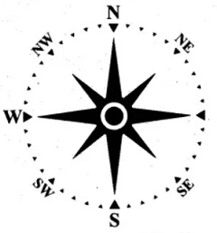
• These four main directions are called the cordinal directions.
• Direction is usually indicated on a map by a North-South line,
with the North direction represented by an arrow head.
3. Explain the major uses of GPS?
Explain about any one.
Advantages of GPS:
• GPS technology has tremendous applications in everything from
mobile phones, watches, bulldozers, shipping containers and ATMs.
• The main purpose of GPS is to help in providing accurate
transport data (distance, route and direction). It helps in military searches
and rescue in wars. It can work as a reliable tourist guide.
• GPS helps during accident and rescue efforts, speeding the
delivery of emergency services and disaster relief.
• Weather forecasting, earthquake monitoring and environmental
protection can be done effectively by using GPS.
Related Topics