Mapping Skills | Geography - Classification/Types of Maps | 9th Social Science : Geography: Mapping Skills
Chapter: 9th Social Science : Geography: Mapping Skills
Classification/Types of Maps
Classification of Maps
It is not possible
to show all the data of an area on a map. The details that are to be shown may vary
according to requirement. Therefore, it is essential
to consider the scale and
purpose while preparing maps.
Types of Maps
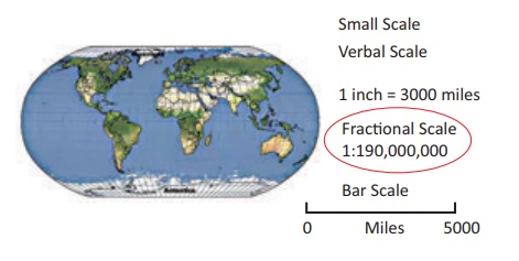
a) On the basis of scale, maps
can be classified
into:
·
Large scale maps: Large amount of detail; can
only show a small area.
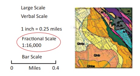
·
Small scale map: Small amount of detail; can
show a large area.
b) On the basis of utility and purpose, they are
classified as:
·
General
maps / Topographic Maps (physical and political
maps)
·
Thematic
map (spatial variations of
single phenomena)
·
Special
purpose maps (Braille
maps for blind people, maps for neo literates,
military maps, navigational charts, etc).
Presume a tourist wants to enjoy a holiday
at a place. What type of map should he look for?
Obviously,
a tourist map or a travelogue.
A travelogue includes all the information
required by a tourist like communication, transportation, hotels, tourist
spots, health centres, ATM, petrol stations etc.
Topographical
maps and weather maps
Topographical maps show main features
like landforms, water features, forests, settlements, agricultural fields, other
land use, transportation and communication
networks. These maps are general purpose maps
and are drawn
at quite
large scales.
The Survey of India prepares
the topographical maps in India for the entire country.
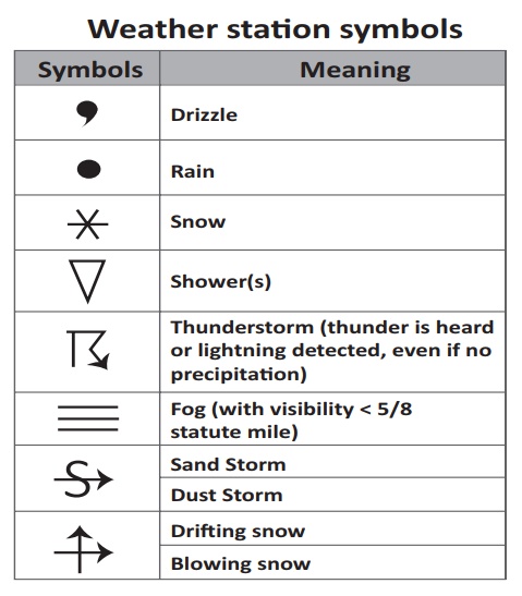
A weather map is the technique of meteorologists to display all the weather
data recorded at various stations
of a country at a
particular point of time into a compact
outline map using symbols
and isolines. A weather
map, otherwise called a synoptic
chart, helps in weather analysis and weather forecast of the
country/region for the next two to three
days.
Related Topics