Chapter: Civil Surveying : Fundamentals and Chain Surveying
important Questions and Answers: Introduction And Chain Surveying
INTRODUCTION AND CHAIN SURVEYING
1.
Define Surveying. What are the fundamental principles of surveying?
Surveying is an art of
determining the relative positions of various points on, above or below the
surface of the earth by means of direct or indirect measurement of distance,
direction and elevation.
The
principles of surveying are:
(i).
Working from whole to part.
(ii). To locate a new station by
at least two measurements (angular, linear) from fixed reference points.
2.
What is the object or purpose of surveying?
The primary object of surveying
is to prepare a plan or map to show the relative position of the objects on the
surface of the earth. It is also used to determine the areas, volumes and other
related quantities.
3. Name the
different ways of classification of surveys.
a.Primary classification
(i).
Plane surveying
(ii). Geodetic surveying. b.
Secondary classification
(i). Based on instruments used (ii). Based on
methods.
(iii).
Based on object
(iv).
Based on nature of the field
4. Differentiate between plane
and geodetic surveying.
Plane surveying
The curvature of the
earth is neglected.
A line joining any two
points is considered straight.
The triangle formed by
any three points is considered as plane triangle.
It is done on a area
less than 250 Km 2
Geodetic surveying.
The curvature of the
earth is taken.
A line joining any two
points is considered as curved line.
The triangle formed by
any three points is considered as spherical triangle.
It is done on a area
greater than 250 Km 2
5. Classify surveying based on the
equipments.
1 Chain
surveying
2 Compass
surveying
3 Plane
table surveying
4
Theodolite surveying
5
Tacheometric surveying
6
Photogram metric surveying
7
Aerial surveying
6
Explain the constructions of a diagonal scale.
For a given short length (
PQ=PR), draw a right angle triangle. Its base( PR) and height (PQ) are equal. A
short length is divided into a number of parts by using the principle of
similar triangles in which like sides are proportional.
Thus,
1-1
represents 1/ 10 PQ
9-9
represents 9/ 10 PQ
7. Define chain surveying. What
is the fundamental principle of chain surveying?
Chain surveying is the type of surveying in which only linear
measurements are made in the field.
The main principle of chain surveying or chain triangulation
is to provide a framework consist of number of well-conditioned triangles or
nearly equilateral triangles. It is used to find the area of the field.
8. What is a well-conditioned
triangle? What is its specific advantage?
A triangle is said to be well- conditioned or well
proportioned when it contains no angle smaller than 300 and no angle
greater than 1200 .
The main principle of chain surveying is chain triangulation.
It consists of frame work of triangles. To plot the network of triangles
accurately, the triangles must be nearly equal to equilateral or
well-conditioned. The distortion due to errors in measurement and plotting
should be minimum.
9. What are the operations
involved in chain survey?
(i). Ranging: The process of locating intermediate points on a
straight line between two end points in a straight line.
(ii).
Chaining: The process of measuring the distance with a chain or tape.
(iii). Offsetting: The process of measuring the lateral
distance of the object from the survey line to the left or right according to
their positions.
10. What are the instruments
required for a chain survey?
Chain or tape, Arrows, Pegs, Ranging rods, Offset rods, Laths
or whites, Plumb bob, Cross staff and Mallet.
11.
Write the different types of Chain.
(i).
Metric chain
(ii).
Non-Metric chain
(a).Gunter's chain
or Surveyor's chain
(b).
Engineer's chain
(c).
Revenue chain
(d).
Steel band.
1. Differentiate
between Gunter's chain and Engineer's Chain
Gunter's chain or Surveyor's
chain
It
is 66 feet long and divided in to 100 links. 1link = 0.66 feet
Measurements
are in miles and furlongs.
Engineer's chain
It
is 100 feet long and divided in to 100 links. 1link = 1 feet
Measurements are
in feet and decimals
13.
Define: (a).Main stations.
Main station is a prominent point
on the chain line and can be either at the beginning of the chain line or at
the end or along the boundary.
(b).
Subsidiary stations:
The
stations located on the main survey lines are known as Subsidiary
stations.
(c).
Tie stations:
These are also subsidiary
stations taken on the main survey lines to locate the details of the object.
14. Distinguish between a check
line and a tie line.
Check line
Check lines or Proof lines are
the lines which are run in the field to check the accuracy of the work
The length of the check line
measured in the field must agree with its length of the plan.
Tie line
The main object of running a tie
line is to take the details of the objects.
Tie line is a line which joints
subsidiary stations or tie stations on the main line.
15. What are the instruments used
for setting out right angles to a chain line?
(i).
Cross staff.
a. Open
cross staff
b. French
cross staff
c.
Adjustable cross staff (ii). Optical square.
(iii). Prism square (iv). Site square.
16.
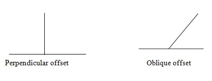
What are offsets? Classify them.
An offset is the lateral distance
of an object or ground feature measured from a survey line. The two types of
offsets are,
(i).
Perpendicular offset: The angle of offset from a point on a chain line is 900.
17.
What is the use of a line Ranger?
The line Ranger is a small
reflecting instrument used for fixing intermediate points on the chain lines.
Without going to either end, we can fix the intermediate points.
18.
What are the stages of fieldwork in chain
surveying? Or What are the steps involved in chain survey?
1. Reconnaissance:
It is the preliminary inspection of the area to be surveyed.
2. Marking
and fixing Survey lines.
3.
Running survey lines.
4. Taking
Offsets.
19.
What are the different tape corrections?
1. Correction
for absolute length or standardisation.
2. Correction
for temperature.
3. Correction
for pull or tension.
4. Correction
for sag. (- ve)
5.
Correction for slope. (- ve)
20.
What are the errors in chaining?
(i). Compensating Errors: Which
are liable to occur in either direction and tend to compensate.
(ii). Cumulative Errors: Which
occur in the same direction and tend to add or subtract. It may be positive
(measured lengths more than the actual length) or negative (measured lengths
less than the actual length).
21.
What are the different sources of errors in chain surveying?
(i).
Instrumental errors: incorrect length of the chain (Cumulative Errors).
(ii). Personal error: Bad ranging (Cumulative
Errors). Careless holding (Compensating Errors). Bad straightening (Cumulative
Errors). Non- horizontality (Cumulative Errors). Sag in chain (Cumulative
Errors). Miscounting and misreading and booking.
(ii).
Natural Errors: Variation in
temperature. (Cumulative Errors).
22.
Enumerate the instruments used for measurement of lengths of survey lines.
(i). Chain or tape. (ii). Passometer. (iii).
Pedometer (iv). Odometer
(v).
Speedometer.
Related Topics