Chapter: Civil Surveying : Fundamentals and Chain Surveying
Surveying: The Intersection Method
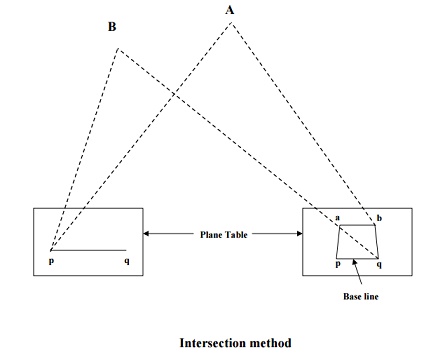
The INTERSECTION
method.
This method is useful where it is not possible to
measure the distances on ground as in case of a mountainous country. Hence,
this method is employed for locating inaccessible points, the broken
boundaries, rivers, fixing survey stations, etc. The procedure is as follows:
(i)
Select two stations P and Q so that the
points to be located on paper are easily seen from them.
(ii)
Plot the line pq, which is known as the
base line, on paper. This can be done in one of the two ways:
a.
The table can be centered and leveled at
station P and then after orienting at station Q, the distance PQ can be
accurately measured and put up to some scale on the paper.
b.
The line pq can be drawn to some scale
on the paper and then the board can be adjusted from station P by back sighting
at station Q.
(iii)
From station P, draw rays for stations
A, B, etc.
(iv)
Shift the table to station Q and after
proper orientation, take rays of stations A, B etc.,
(v)
The intersection of rays from stations P
and Q will give points a, b etc. on paper, as shown in figure.
Related Topics