Chapter: Satellite Communication : Satellite Applications
Mobility Management
Mobility
Management:
One
of the major features used in all classes of GSM networks (cellular, PCS and Satellite)
is the ability to support roaming users. Through the control signaling network,
the MSCs interact to locate and connect to users throughout the network.
"Location
Registers" are included in the MSC databases to assist in the role of
determining how, and whether connections are to be made to roaming users. Each
user of a GSM MS is assigned a Home Location Register (HLR) that is used to
contain the user's location and subscribed services.
Difficulties facing the operators
can include;
a.
Remote/Rural Areas. To service remote areas, it is often economically
unfeasible to provide backhaul facilities (BTS to BSC) via terrestrial lines
(fiber/microwave).
b.
Time to deploy. Terrestrial build-outs can take years to plan and implement.
c.
Areas of ‘minor’ interest. These can include small isolated centers such as
tourist resorts, islands, mines, oil exploration sites, hydro-electric
facilities.
d.
Temporary Coverage. Special events, even in urban areas, can overload the
existing infrastructure.
1. GSM service
security:
GSM
was designed with a moderate level of service security. GSM uses several
cryptographic algorithms for security. The A5/1, A5/2, and A5/3 stream ciphers
are used for ensuring over-the-air voice privacy.
GSM
uses General Packet Radio Service (GPRS) for data transmissions like browsing
the web. The most commonly deployed GPRS ciphers were publicly broken in
2011The researchers revealed flaws in the commonly used GEA/1.
2. Global
Positioning System (GPS) :
The
Global Positioning System (GPS) is a satellite based navigation system that can
be used to locate positions anywhere on earth. Designed and operated by the
U.S. Department of Defense, it consists of satellites, control and monitor
stations, and receivers. GPS receivers take information transmitted from the
satellites and uses triangulation to calculate a user’s exact location.
GPS
is used on incidents in a variety of ways, such as:
To determine position locations; for example, you need to radio a helicopter
pilot the coordinates of your position location so the pilot can pick you up.
To navigate from one location to another; for example, you need to travel from
a lookout to the fire perimeter.
To create digitized maps; for example, you are assigned to plot the fire
perimeter and hot spots.
To determine distance between two points or how far you are from another
location.
The
purpose of this chapter is to give a general overview of the Global Positioning
System, not to teach proficiency in the use of a GPS receiver. To become
proficient with a specific GPS receiver, study the owner’s manual and practice
using the receiver.
The
chapter starts with a general introduction on how the global positioning system
works. Then it discusses some basics on using a GPS receiver.
Three Segments of GPS:
Space Segment — Satellites orbiting
the earth
The
space segment consists of 29 satellites circling the earth every 12 hours at
12,000 miles in altitude. This high altitude allows the signals to cover a
greater area. The satellites are arranged in their orbits so a GPS receiver on
earth can receive a signal from at least four satellites at any given time.
Each satellite contains several atomic clocks.
Control Segment — The control and
monitoring stations
The
control segment tracks the satellites and then provides them with corrected
orbital and time information. The control segment consists of five unmanned
monitor stations and one Master Control Station. The five unmanned stations
monitor GPS satellite signals and then send that information to the Master
Control Station where anomalies are corrected and sent back to the GPS
satellites through ground antennas.
User Segment — The GPS receivers
owned by civilians and military
The
user segment consists of the users and their GPS receivers. The number of
simultaneous users is limitless.
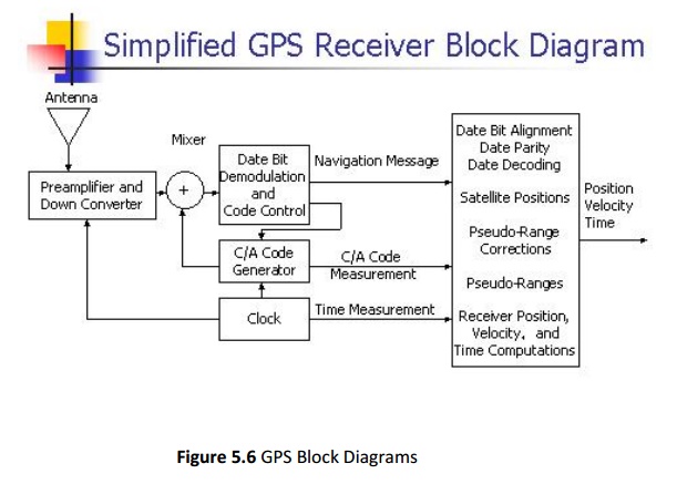
How GPS Determines a Position:
The
GPS receiver uses the following information to determine a position.
Precise location of satellites
When a GPS receiver is first turned on, it downloads orbit information from all
the satellites called an almanac. This process, the first time, can take as
long as 12 minutes; but once this information is downloaded, it is stored in
the receiver’s memory for future use.
Distance from each satellite
The
GPS receiver calculates the distance from each satellite to the receiver by
using the distance formula: distance = velocity x time. The receiver already
knows the velocity, which is the speed of a radio wave or 186,000 miles per
second (the speed of light).
Triangulation to determine position
The
receiver determines position by using triangulation. When it receives signals
from at least three satellites the receiver should be able to calculate its
approximate position (a 2D position). The receiver needs at least four or more
satellites to calculate a more accurate 3D position.
Using a GPS Receiver :
There
are several different models and types of GPS receivers. Refer to the owner’s
manual for your GPS receiver and practice using it to become proficient.
When working on an incident with a GPS receiver it is important to:
Always have a compass and a map.
Have a GPS download cable.
Have extra batteries.
Know memory capacity of the GPS receiver to prevent loss of data, decrease in
accuracy of data,or other problems.
Use an external antennae whenever possible, especially under tree canopy, in
canyons, or while flying or driving.
Set up GPS receiver according to incident or agency standard regulation;
coordinate system.
Take notes that describe what you are saving in the receiver.
Related Topics