Geography - Methods of Representing Relief Features | 11th Geography : Chapter 10 : Representation of Relief Features and Climatic Data
Chapter: 11th Geography : Chapter 10 : Representation of Relief Features and Climatic Data
Methods of Representing Relief Features
Methods
of Representing Relief Features
The important methods of representing
relief features are hachures, contours, form lines, spot heights, bench marks,
trigonometrical points, hill shading, layer-colouring, and so on. Each method
has its own merits and demerits in depicting the relief of the land.
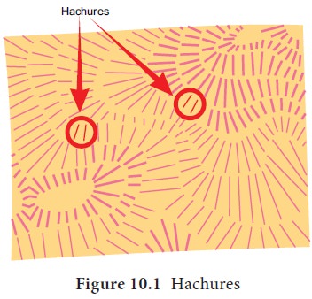
Hachures
are small lines
drawn to represent slopes. The lines are drawn thicker to represent steeper
slopes and thinner for gentle slope. The slopes above 45° is depicted
completely in black colour.
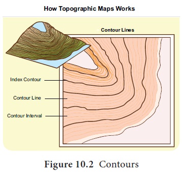
Contours
are imaginary lines
connecting places having same elevation above mean sea level. They are drawn in
brown colour.
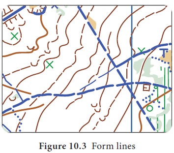
Form
lines are like contours
representing features that are not actually surveyed. They are shown by broken lines.
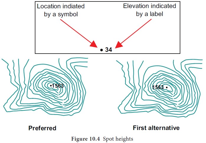
Spot heights are heights of places surveyed and they denote the actual height above mean sea level. They are shown in maps as dots with their respective values written beside it.
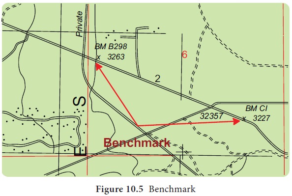
Bench
marks represent the
actual height of a tall structure like a tall building, pillar, bridges or any other
object of permanent nature. They are marked with the letters BM with the
respective height.
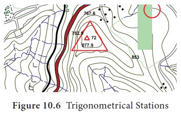
Trigonometrical Stations are points included in the triangulation survey and are marked in the map with a triangle with the actual height of the place.
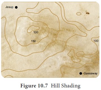
Hill Shading (levels of gray) is a method of representing relief on a map by depicting the shadows that would be cast by elevated areas if light wre shining from a certain direction.
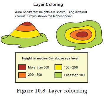
Layer
Colouring is a method showing relief in layers and each layer is
given a different colour. Physical maps in atlas and wall maps use this method
to show relief features. Ocean depth is also shown in various shades of blue.
There is an international recognition for colours used in these maps.
Accordingly blue represents water bodies, green for plains, various shades of
brown for highlands and white for snow covered peaks.
Contours
Contour is universal method to show
the relief. The unit of measurement of contour is generally metres above the
mean sea level. Contour has an advantage that it does not hide the other
features drawn on the toposheet. Reading contours is a skill that helps us to
understand the actual landscape. The skill can be obtained by understanding the
salient features of contours. They are as follows:
•
Contours are drawn at regular intervals in brown colour. Generally 20m
interval is followed in 1:50,000 and 100m interval in 1:250,000 toposheet.
•
Every fifth contour is a dark line to enhance map reading.
•
The value of contour is printed by breaking the contour line andalso
given at the edge of the toposheet.
• Generally contours never cut or cross each other. In case of water fall and cliffs contours almost ouch a same point or a line. In over hanging cliff the contours cut each other.
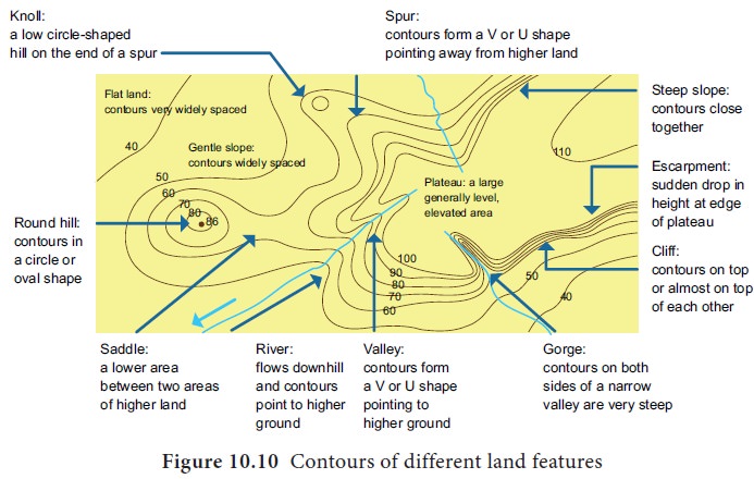
Figure 10.10 gives the general
features shown by contours.
Drawing Cross Section from Contours
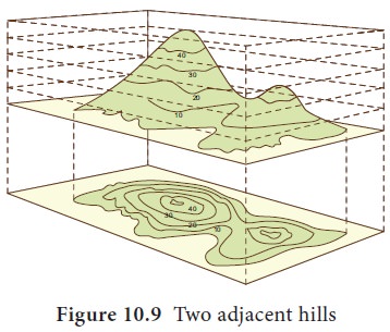
The following figure shows the way
two adjacent hills are shown by contours.
a) Two adjacent hills shown by contour
Drawing cross section of the contours allows one to know the exact landform depicted in the toposheet.
Drawing
cross section involves selecting a section within the portion of the contour,
marking the intersections of these selected contours on suitable vertical scale
and joining these points to indentify the land form. Generally closely spaced
contours indicate that the slope is steep, and widely spaced contours indicate
that the slope is gentle. The following pictures show contours and cross
sections of a hill and a depression.
Steps to be followed to draw contours and the cross section:
a.
Draw the contours in brown colour.
b.
Draw a line AB for which the cross section has to be drawn.
c.
Below the contour draw required number of horizontal lines of equal
distance and interval (2mm) to represent all the contour values given in the
diagram
d.
Write the value of all the contours in such a way that the lowest value
of the contour forms the base line and the values increase according to the
contour interval given in the diagram.
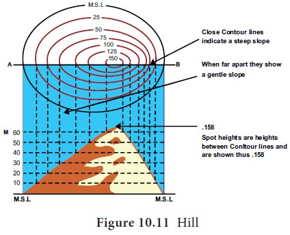
e.
Draw vertical lines from each intersection point on the line AB with the
contours to the horizontal line representing its value.
f.
Join all these points to identify the feature shown.
g.
Shade the feature in black to complete the cross section.
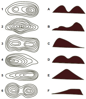
General
instruction to identify features shown in contours:
•
A hill is shown by circular contours with height less than 1,000 m.
•
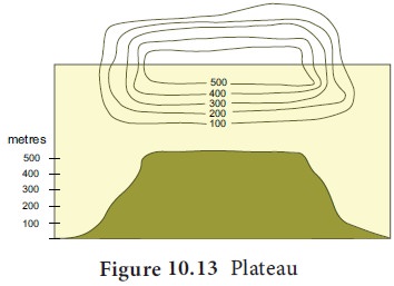
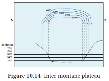
A plateau is an elevated land represented byinnermostcontourroughlyrectangular
in shape and closer outer contours. The height may generally vary from 300m to
600 metres. If a plateau is enclosed by mountains, it is called intermontane
plateau and when it is formed in the foot hills it is called piedmont plateau.
•
A ridge is an elongated and steep sloped high mountain with two or more peaks
shown by elliptical contour lines. A narrow low depression between two peaks is
called Col. Saddle is similar to a col but higher, broader and gently sloping from
peaks of a ridge.
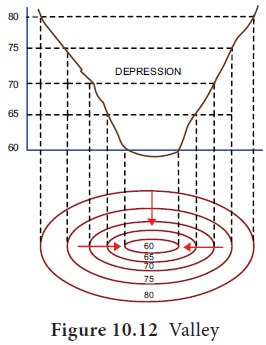
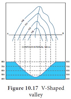
•
A valley is a long depression with steep slope formed by the vertical
erosion of the river within the stretch of upland. The contours bend sharply
across the river in a ‘V’ shape with the apex pointing towards higher
elevations.
•
Spurs are projection of land from higher to lower ground. Contours bend smoothly with the apex of the ‘V’
pointing towards lower ground.
• A waterfall occurs when there is a sudden difference in height of the river valley.A waterfall is a place where water flows over a vertical drop or a series of steep drops in the course of a stream or river.
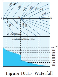
It is represented by contours meeting at a same point on
the hill slope. The difference between the value of the highest and the lowest
contour touching the same point gives the height of the waterfall.
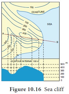
•
A cliff is a steep sloped exposure of a valley or coast. If it is near sea we
call it sea cliff.
•
Gorge is a very steep valley at higher elevations formed by river erosion. It can be
identified by closely converging contours in the river course.
•
A volcano is represented by closed contours with the innermost contours having lesser
values than the surrounding, denoting the crater depression.
Exercise 1
Match
the following
Related Topics