Chapter: 10th Social Science : Geography : Chapter 1 : India - Location, Relief and Drainage
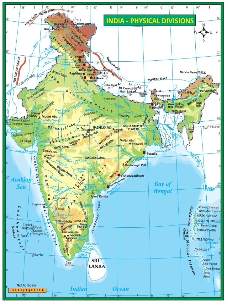
Major Physiographic Divisions of India
Major Physiographic Divisions of
India
The
majestic Himalayan peaks in the north, the beautiful beaches in the south, the
great Indian desert in the west and the breathtaking natural heritage in the
east make India a geographically vibrant, colourful and truly incredible
country.
There is
a varied nature of physiographic divisions in India. Though the country has
many landforms based on the major differences, it is divided into the following
five physiographic divisions:
1. The
Northern Mountains
2. The
Northern Plains
3. The
Peninsular plateau
4. The
Coastal Plains
5. The
Islands
1. The Northern Mountains
The
Northern Mountains consist of the youngest and the loftiest mountain chains in
the world. It was formed only few millions years ago and formed by the folding
of the earth crust due to tectonic activity. It stretches for a distance of
2,500 km from the Indus gorge in the west to Brahmaputra gorge in the east. The
width of the Northern Mountains varies from 500 km in Kashmir to 200 km in
Arunachal Pradesh. The Pamir Knot, popularly known as the “Roof of the World” is
the connecting link between the Himalayas
and the high ranges of Central Asia. From the Pamir, Himalayas extend eastward
in the form of an arc shape. The term “Himalaya” is derived from Sanskrit. It
means “The Abode of Snow”.
The
Northern Mountains that function as a great wall is grouped into three
divisions.
1) The Trans-Himalayas
2) Himalayas
3) Eastern
Himalayas or Purvanchal hills.
Aravalli range is the oldest fold mountain range in India.
1. The Trans-Himalayas
It lies
to the north of the great Himalayan range. It lies in Jammu and Kashmir and
Tibetian plateau. As its areal extent is more in Tibet, it is also known as
Tibetean Himalayas. The Trans-Himalayas are about 40 km wide in its eastern and
western extremities and about 225 km wide in its central part. They contain the
Tethys sediments. The rocks of this region contain fossils bearing marine
sediments which are underlain by ‘Tertiary granite’. It has partly
metamorphosed sediments and constitutes the core of the Himalayan axis. The
prominent ranges of Trans Himalayas are Zaskar, Ladakh, Kailash, and Karakoram.
2. The Himalayas
It
constitutes the core part of northern mountains. It is an young fold mountain.
It was formed by the movement of Eurasia land mass in the north and Gondwana
land mass in the south. The Tethys sea found between these two land masses was
uplifted by the compression and the resultant landform was the Himalayas.It
consists of many ranges. The main divisions of the Himalayas are the
(i) The
Greater Himalayas/The Himadri
(ii) The
Lesser Himalayas /The Himachal
(iii) The Outer Himalayas/The
Siwaliks
(i) The Greater Himalayas or the Himadri
The Greater Himalayas rise abruptly like a wall
north of the Lesser Himalayas. The Greater Himalayas are about 25 km wide. Its
average height is about 6,000 m. The Greater Himalayas receive lesser rainfall
as compared to the Lesser Himalayas and the Siwaliks. Physical weathering is
less effective over the Greater Himalayas as compared to the other ranges.
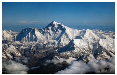
Almost all the lofty peaks of Himalayas are located in this range. The notable
ones are Mt. Everest (8,848 and
Kanchenjunga (8,586 m). Mt.Everest is located in Nepal and Kanchenjunga is
located between Nepal and Sikkim. This range is the most continuous of all
ranges. It is region of permanent snow cover. So, it has many glaciers. Gangothri, Yamunothri and Siachen are
some of them.
• Himalaya is the home of several
high peaks.
• However, it holds the record of
having the maximum number of highest peaks among any mountain range in world.
• Out of 14 highest peaks in this
world, Himalayas holds 9.
(ii) The Lesser Himalayas or The Himachal
It is the middle range of Himalayas. Height of this
range varies from 3, 700 to 4,500 m. Its width varies upto 80 km. The major
rocks of this range are slate, limestone and quartzite. This region is
subjected to extensive erosion due to heavy rainfall, deforestation and
urbanization. Pir Panjal, Dhauladhar and Mahabharat are the mountain ranges
found in this part. Major hill stations of the Himalayas are located in this
range. Shimla, Mussourie, Nainital,
Almora, Ranikhet and Darjeeling are
the familiar ones.
• The major passes in the Himalaya
are Karakoram pass (Jammu and Kashmir), Zojila pass, Shipkila pass (Himachal
Pradesh), Bomdila pass (Arunachal Pradesh), Nathula pass and Jhelepla pass
(Sikkim).
• The Khyber pass which connects
Pakistan and Afganisthan, and Bolan pass in Pakistan are theimportant passes of
the Indian subcontinent
(iii) The Outer Himalayas/The Siwaliks
The
Siwaliks extend from Jammu and Kashmir to Assam. It is partly made by the
debris brought by the Himalayan rivers. The altitude varying between 900-1100
metres average elevation of this range is 1000 m. The width of Siwaliks varies
from 10 km in the east to 50 km in the west. It is the most discontinuous
range. The longitudinal valleys found between the Siwaliks and the Lesser
Himalayas are called Duns in the west and Duars in the east. These are the
ideal sites for the development of settlements in this region.
3. Purvanchal Hills
These are the eastern off-shoot of Himalayas. It
extended in the north-eastern states of India. Most of these hills are located
along the border of India and Myanmar while others are inside India. Dafla
Hills, Abor Hills, Mishmi Hills, Patkai Bum Hills, Naga Hills, Manipur Hills,
Mizo Hills, Tripura Hills, Mikir Hills, Garo Hills, Khasi Hills and Jaintia
Hills are the hills which are collectively known as purvanchal Hills.
Importance of Himalayas
• Himalayas blocks southwest monsoon winds and
causes heavy rainfall to north India.
• It forms a natural barrier to the sub-continent.
• It is the source for many perennial rivers like
Indus, Ganges, Brahmaputra etc.
• The Northern Mountains are described as the
paradise of tourists due to its natural beauty.
• Many hill stations and pilgrim centres like
Amarnath, Kedarnath, Badrinath and Vaishnavidevi temples are situated here.
• It provides raw material for many forest based
industries.
• It prevents the cold winds blowing from the
central Asia and protects India from severe cold.
• Himalayas are renowned for the rich biodiversity.
2. The Great Northern Plains
This
fertile plain lies to the south of the northern mountains. This plain is one of
the most extensive stretches of the alluvium in the world and is deposited by
the rivers Indus, Ganga, Brahmaputra and their tributaries. The length of the
plain is about 2,400 km and the width varies from 240 to 320 km. Its width
increases from east to west. It covers an area of over 7 lakh sq.km.
The Great
Plains of India is remarkably a homogeneous surface with an imperceptible
slope. They are formed mostly by the depositional process of the Himalayan and
Vindhyan rivers. These rivers deposit enormous quantity of sediments deposited
along the foothills and flood plains. The important characteristics featuress
of sediment deposition in the plains areas as follows.
(a) The Bhabar Plain
This plain is made up of gravels and unassorted
sediments deposited by the Himalayan rivers. The porosity of this plain is so
high that most of the small streams flow over this region disappear. Its width
varies from 8 to 15 km. It is wider in the western plains (Jammu Division) than
in the east (Assam). This plain is not suitable for cultivation, only big trees
with large roots thrive in this region.
(b)
The Tarai Tract
It is a
zone of excessive dampness, thick forests and rich wild life. This tract lies
to the south of Bhabar plains. The width of this belt is 15-30 km. The Tarai is
wider in the eastern parts of the Great Plains, especially in Brahmaputra
Valley due to heavy rainfall. In many states, the Tarai forests have been
cleared for cultivation.
(c)
The Bhangar Plains
The Bhangar represent the upland alluvial tracts of
the Great Plains of India, formed by the older alluviums. The Bhangar land lies
above the flood limits of the rivers. This soil is dark in colour, rich in
humus content, well drained and useful for agriculture.
(d)
The Khadar Plains
The new
alluvium tracts along the courses of the rivers are known as the ‘Khadar’ or
‘Bet’ lands. The Khadar tracts are enriched by fresh deposits of silt every
year during rainy seasons. The Khadar land consists of sand, silt, clay and
mud. It is highly fertile soil.
(e)
Delta
Triangle
shaped fertile land at the mouth of Ganga and Brahmaputhra rivers is called as
the Sundarban delta. It is the biggest and fastest growing delta. It is an area
of deposition as the river flows in this tract sluggishly. The deltaic plain
consists mainly of old mud, new mud and marsh. In the delta region, the uplands
are called ‘Chars’ while the marshy
areas are called ‘Bils’.
On the basis of deposition of sediments by various
rivers and topographical characteristics, the Northern Plains of India is
divided into the following four major regions:
1) Rajasthan Plains: It is located
to the west of Aravalli range. It covers
an area of about 1,75,000 sq.km. Rajasthan plain is formed by the deposition of
the river Luni and the long vanished river Saraswathi. There are several salt
lakes in Rajasthan. The Sambhar salt lake (Pushkar Lake) near Jaipur is the
prominent one.
The Thar
desert, also known as the Great Indian desert is a large arid region in the
north western part of the Indian subcontinent that covers an area of 2,00,000
km2 and forms a natural boundary between India and Pakistan. It is the world
7th largest desert.
The desert lies in the western part of the aravalli
range and covers 2/3 of Rajastan state. There are two major divisions in the
Thar desert. They are known as the Actual desert region (Marusthali) and the
semi desert region (Bhangar). Many different types of sand dunes and salt lakes
(Dhands) are seen here.
2) Punjab
- Haryana Plains: It lies to the north-east of the Great Indian
Desert. This plain is found over an area of about 1.75 lakh sq.km. The Punjab -
Haryana plains are formed by the deposition of the rivers Sutlej, Beas and
Ravi. This plain acts as water - divide (doab). The two major watershed it
divides are Yamuna – Sutlej and Ganga – Yamuna.
3) Ganga
Plains: It extends from the Yamuna River
in the west to Bangladesh in the east. The total area covered by this plain is
about 3.75 sq.km. River Ganga and its tributaries such as Ghaghra, Gandak,
Kosi, Yamuna, Chambal, Betwa etc. constitute this plain by their sediments and
make a great plain in India. It is the largest plain of India. The general
slope of the entire plain (upper, middle and lower Ganga plains) is towards
east and south-east.
4) Brahmaputra
Plains: It is located mainly in the
state of Assam. It is a low - level plain located in the eastern part of the
Great Plains of India and is formed by the deposits of river Brahmaputra. It
covers an area of about 56,275 sq.km. These plains create alluvial fans and
marshy tracts.
3. The Peninsular Plateaus
The
plateau region lies to the south of the Great Northern Plains. This is the
largest physiographic division of our country. It covers an area of about 16
lakh sq.km (about half of the total area of the country). It is an old rocky
plateau region. The topography consists of a series of plateaus and hill ranges
interspersed with river valleys.
Aravalli
hills mark the north-western boundary of the plateau region. Its northern and
north-eastern boundaries are marked by the Bundelkhand upland, Kaimur and
Rajmahal hills. The Western Ghats and the Eastern Ghats mark the western and
eastern boundaries respectively. The altitude of a large portion of the plateau
is more than 600 m from mean sea level. The
peak of Anaimudi is the highest point
in the plateau. Its height is 2,695 m and is located in Anaimalai. The
general slope of this plateau is towards east. The Great Plateau is a part of
the Gondwana (very ancient one) land mass. Due to the old age, the rivers in
this region attained their base level and developed broad and shallow valleys.
The river Narmada divides the plateau region of
India broadly into two parts. The region lying to the north of the Narmada is
called the Central Highlands and the region lying to the south of Narmada is
called the Deccan Plateau. All the major rivers (Mahanadi, Godavari, Krishna,
Kaveri etc.) lying to the south of the Vindhyas flow eastwards and fall into
the Bay of Bengal. Narmada and Tapti are the two rivers situated to the south
of the Vindhyas flow westward. Their movement towards west is due to the
presence of a rift valley in the region.
a) Central Highlands
The Central Highlands extend between the river
Narmada and the Northern Great Plains. The Aravallis form the west and
northwestern edge of the Central Highlands. These hills extend from Gujarat,
through Rajasthan to Delhi in the northwesterly direction for a distance of
about 700 km. The height of these hills is about 1,500 m in southwest while
near Delhi the height is hardly 400 m. Gurushikhar
with 1,722 m is the highest peak of
this range.
The Western part of the Central Highland is known
as the Malwa Plateau. It lies to the southeast of Aravallis and to the north of
Vindhyachal Range. The rivers Chambal, Betwa and Ken drain the Malwa Plateau
before they join the river Yamuna. The part of the Central Highlands which
extends to the east of Malwa Plateau is known as Bundelkhand and its further
extension is known as Bagelkhand. The eastern part of the Central High lands
which lies in the north-eastern part of the Indian Plateau is known as Chhota
-Nagpur Plateau. It covers much of Jharkhand, adjacent parts of Odisha, West
Bengal, Bihar and Chhattisgarh. This region is very rich in mineral resources
particularly iron ore and coal.
b) Deccan Plateau
This
physiographic division is the largest part of the plateau region of India. The
shape of this plateau is roughly triangular. One of the sides of this triangle
is marked by the line joining Kanyakumari with Rajmahal Hills and this line
passes through the Eastern Ghats. The second arm is marked by the Satpura
Range, Mahadeo Hills, Maikal Range and the Rajmahal Hills. The third arm is
marked by the Western Ghats. The area of this Plateau is about 7 lakh square km
and the height ranges from 500 to 1000 m above sea level.
1. The Western Ghats
The Western Ghats forms the western edge of the
Peninsular Plateau. It runs parallel to the Arabian Sea coast. The northern
part of this range is called as Sahyadris. The height of the Sahyadris
increases from north to south. Anaimudi is a sort of tri-junction of the
Anaimalai Range, the Cardamom Hills and the Palani Hills. Kodaikanal is a
beautiful hill resort situated on the Palani Hills.
2. The Eastern Ghats
Eastern
Ghats run from southwest to northeast form the eastern edge of this Plateau.
This range is also called as Poorvadri. The Eastern Ghats join the Western
Ghats at the Nilgiri hills, bordering Karnataka and Tamil Nadu. The Eastern
Ghats are not continuous like the Western Ghats. The rivers of Mahanadi,
Godavari, Krishna, Pennar and Kaveri have dissected this range at many places.
4. The Coastal Plains
The
Peninsula Plateau of India is flanked by narrow coastal plains of varied width
from north to south. They were formed by the depositional action of the rivers
and the erosional and depositional actions of the sea-waves. The Indian coastal
plains are divided into the following two divisions:
1. The Western Coastal Plains
2. The Eastern Coastal Plains.
1. The Western Coastal Plain
It lies
between the Western Ghats and the Arabian Sea. It extends from Rann of kutch in
the north to Kanyakumari in the south and its width varies from 10 to 80 km. It
is mainly characterised by sandy beaches, coastal sand dunes, mud flats,
lagoons, estuary, laterite platforms and residual hills. The northern part of
the West Coastal Plain is known as Konkan Plain. The middle part of this plain
is known as Kanara. The southern part of the plain is known as Malabar coast
which is about 550 km long and 20-100 km wide. This part of the coast is
characterized by sand dunes. Along the coast, there are numerous shallow
lagoons and backwaters called Kayals
and Teris. Vembanad is a famous back water lake found in this region.
2. The Eastern Coastal Plain
It lies between the Eastern Ghats and the Bay of
Bengal and, stretches along the states of West Bengal, Odisha, Andhra Pradesh
and Tamil Nadu. These plains are formed by the alluvial fillings of the
littoral zone by the east flowing rivers of India. The coastal plain consists
mainly of the recent alluvial deposits. This coastal plain has a regular
shoreline with well-defined beaches. The coastal plain between Mahanadi and
Krishna river is known as the Northern Circars and the southern part lies
between Krishna and Kaveri rivers is called Coromandal coast. Among the back
water lakes of this coast, lake Chilka
(Odisha) is the largest lake in India located to the southwest of the Mahanadi
delta, the Kolleru Lake which lies
between the deltas of Godavari and Krishna and the Pulicat Lake lies in the border of Andhra Pradesh and Tamil Nadu
are the well known lakes in the east coastal plain.
5. The Islands
India has two major island groups namely Andaman
and Nicobar and Lakshadweep. The former group consists of 572 islands and are
located in Bay of Bengal, and the later one has 27 islands and are located in
Arabian Sea. The islands of Andaman and Nicobar are largely tectonic and
volcanic origin. India’s only active volcano is found on Barren Island in
Andaman and Nicobar group of Islands.
a) Andaman and Nicobar Islands
These
islands are located in an elevated portion of the submarine mountains. Since
these islands lie close to the equator, the climate remains hot and wet
throughout the year and has dense forests. The area of the island group is
about 8,249 sq.km. The entire group of islands is divided into two. They are
Andaman in the north and the Nicobar in the south. These island groups are of
great strategic importance for the country. Port Blair is the administrative
capital of the Andaman and Nicobar islands. The Ten Degree Channel separates Andaman from Nicobar group. The
southernmost tip, the Indira Point is
a part of Nicobar Island.
b) Lakshadweep Islands
This is a small group of coral islands located off
the west coast of India. It covers an area of 32 sq. km. Kavaratti is its
administrative capital. Lakshadweep islands are separated from the Maldive
Islands by the Eight Degree Channel. The uninhabited “Pitt Island” of this group has a bird sanctuary. Earlier, it had
three divisions namely Laccadive, Minicoy and Amindivi. It was named as
Lakshadweep in 1973.
c) Offshore Islands
Besides the two group of islands, India has a
number of islands along the Western Coast, Eastern Coast, in the delta region
of Ganga and in the Gulf of Mannar. Many of these islands are uninhabited and
are administered by the adjacent states.
Related Topics