Asia and Europe | Term 3 Unit 1 | Geography | 6th Social Science - Exercises Questions with Answers | 6th Social Science : Geography : Term 3 Unit 1 : Asia and Europe
Chapter: 6th Social Science : Geography : Term 3 Unit 1 : Asia and Europe
Exercises Questions with Answers
Exercise
I. Choose the best answer.
1. Which
is not the western margin of Asia?
(a) Black Sea
(b) Mediterranean Sea
(c) Red Sea
(d) Arabian Sea
Answer: (d) Arabian
Sea
2. The
Intermontane ______ plateau is found between Elbruz and Zagros.
(a) Tibet
(b) Iran
(c) Deccan
(d) The
Yunnan
Answer: (b) Iran
3.
Equatorial climate :
(i) Uniform throughout the year.
(ii) The average / mean rainfall is 200 mm.
(iii) The average temperature is 10°C.
(iv) Of the statements give above,
(a) i alone is correct
(b) ii and iii are correct
(c) i and iii are correct
(d) i and ii are correct
Answer: (a) i alone is
correct
4. Match
list I correctly with list II and select your answer from the codes given
below.
List – I List – II
A.
Malaysia 1. Figs
B.
Thailand 2. Rubber
C.
Korea 3. Teak
D.
Israel 4. Cherry
Codes
A B C D
(a) 2,3,4,1
(b) 4,3,2,1
(c) 4,3,1,2
(d) 2,3,1,4
Answer: (a) 2,3,4,1
5. India
is the leading producer of _____________.
(a) Zinc
(b) Mica
(c) Manganese
(d) Coal
Answer: (b) Mica
6. The
natural boundary between Spain and France is _____________.
(a) The Alps
(b) The Pyrenees
(c) The Carpathian
(d) The Caucasus
Answer: (b) The
Pyrenees
7. The
western and north-western Europe enjoys mild and humid climate.
Choose
the correct option:
(a) These regions are found near the equator
(b) It is influenced by the North Atlantic Drift
(c) It is surrounded by mountains
(d) All of the above
Answer: (b) It is
influenced by the North Atlantic Drift
8. Which
of the following statements is incorrect?
(a) Europe produces electricity from hydel power
(b) All the rivers of Europe originate in the Alps
(c) Most of the rivers in Europe are used for
inland navigation
(d) The rivers of Europe are perennial in nature
Answer: (d) The rivers
of Europe are perennial in nature
9. Choose
the incorrect pair.
a. The Meseta - Spain
b. The Jura - France
c. The Pennines - Italy
d. The Black Forest – Germany
Answer: c. The
Pennines - Italy
10. Which
country in Europe has a very low density of population?
(a) Iceland
(b) The Netherlands
(c) Poland
(d) Switzerland
Answer: (a) Iceland
II. Fill in the blanks.
1. The Taurus and the Pontine ranges radiate from
the Armenian
knot.
2. The wettest place in the world is Mawsynram.
3. Iran is the largest producer of Mineral
resources in the world.
4. Europe connected with south and south east Asia
by Suez
sea route.
5. The national dance of Philippines is Tinikling.
6. The second highest peak in Europe is Mont Blanc.
7. The type of climate that prevails in the
central and eastern parts of Europe is Continental type.
8. The important fishing ground in North Sea is Dogger Bank.
9. The density of population in Europe is 34 persons /
km2.
10. The river Danube passes through nine countries of
Europe.
III. Match
The Following
1. Mesopotomian Plain - HighestRainfall
2. Mawsynram - Norway
3. Rice Bowl of southeast asia - Spain
4. Fjord
Coast - Euphrates & Tigris
5. Bull Fighting – Thailand
Answer;
1. Mesopotomian Plain - Euphrates & Tigris
2. Mawsynram - Highest Rainfall
3. Rice Bowl of southeast asia - Thailand
4. Fjord Coast - Norway
5. Bull Fighting - Spain
IV. Let us learn
1. Assertion
(A): Italy has dry summers and rainy winters
Reason (R): It
is located in the Mediterranean region
(a) Both A and R are individually true and R is
the correct explanation for A
(b) Both A and R are individually true but R is
not the correct explanation for A
(c) A is true, but R is false
(d) A is false, but R is true
Answer: (d) A is false, but R is true
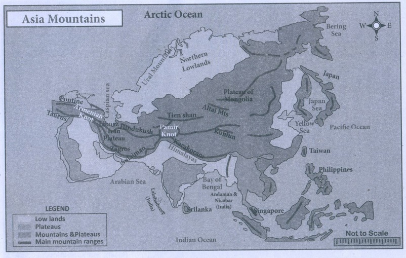
2. Places marked as 1, 2, 3 and 4 in the given map
are noted for the following plains.
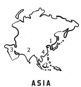
A. Indo – Gangetic plain
B. Manchurian plain
C. Mesopotamian
D.Great plains of China
Match the plains with the notation on the map and
select the correct answer using the codes given below.
Codes:
A B C D
(a) 2 1 4 3
(b) 2 1 3 4
(c) 1 2 3 4
(d) 1 4 3 2
Answer: (b) 2,1,3,4
3. In the given outline map of Asia, the shaded
areas indicate the cultivation of
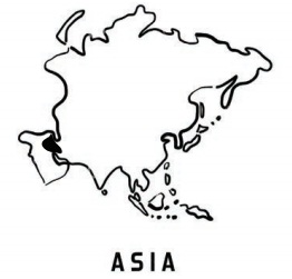
(a) sugarcane
(b) Dates
(c) Rubber
(d) Jute
Answer: (b) Dates
V. Answer in Brief
1. Name
the important intermontane plateaus found in Asia.
The plateau of Anatolia (Pontine
to Taurus)
The plateau of Iran (Elburz
to Zagros mt)
The plateau of Tibet (Kunlun
to Himalayas)
2. Write
a short note on monsoon climate.
Summer is hot and humid while winter
is cool and dry.
3. How
does physiography play a vital role in determining the population of Asia?
The population is unevenly
distributed because of various physical features. River plains and industrial
regions have high density of population, whereas low density is found in the
interior parts of Asia.
4. Name
the ports found is Asia.
Tokyo, Shanghai, Singapore, Hong
Kong, Chennai, Mumbai, Karachi and Dubai are the important seaports in Asia.
5. Asia
is called the ‘Land of Contrasts’-Justify.
Asia is the biggest continent. It
has different types of land features such as mountain, plateau, plain, valley,
bay, island etc. It also has different climatic conditions from the equator to
polar region. Apart from this, many races, languages, religions and cultures
are followed by people who live in Asia. So, Asia is called 'the land of
contrasts'.
6. Name
the important mountains found in the Alpine system.
The Sierra Nevada, the Pyrenees, the
Alps, the Apennines, the Dinaric Alps, the Caucasus and the Carpathian.
7. What
are the important rivers of Europe?
Volga, Danube, Dniper, Rhine, Rhone,
Po and Thames.
8. Name a
few countries which enjoy the Mediterranean type of climate.
Southern Spain, South of France and
Italy Greece, Lebanon, Israel.
9. Give a
short note on the population of Europe.
Europe is the third most populous
continent, after Asia and Africa. The population of Europe was 742 million in
2018, which accounted for 9.73% of the world's population. The population
density in Europe is 34 persons/km2.
10. Name
the important festivals celebrated in Europe.
Christmas, Easter, Good Friday, the
Saint Day, Redentore, Tomatina and Carnival are the important festivals of
Europe.
VI. Distinguish
1.
Intermontane plateaus and southern plateaus.
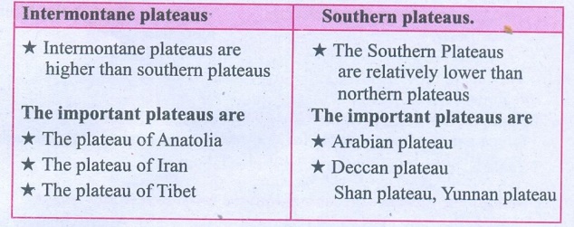
Intermontane
plateaus
• Intermontane plateaus are higher
than southern plateaus
The important
plateaus are
• The plateau
of Anatolia
• The plateau
of Iran
• The plateau
of Tibet
Southern plateaus.
• The
Southern Plateaus are relatively lower than northern plateaus
The important
plateaus are
• Arabian
plateau
• Deccan
plateau Shan plateau, Yunnan plateau
2. Cold
desert and hot desert
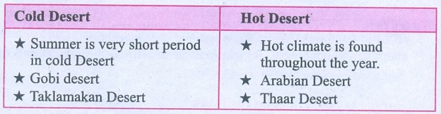
Cold Desert
• Summer is very short period in cold
Desert
• Gobi desert
• Taklamakan Desert
Hot Desert
• Hot climate is found throughout the
year.
• Arabian Desert
• Thaar Desert
3. Tundra
and Taiga.
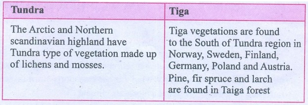
Tundra
The Arctic and Northern Scandinavian highland have Tundra type
of vegetation made up of lichens and mosses.
Tiga
Tiga vegetations are found to the South of Tundra region in
Norway, Sweden, Finland, Germany, Poland and Austria. Pine, fir spruce and
larch are found in Taiga forest
4. The
North western highlands and the Alpine mountain range.
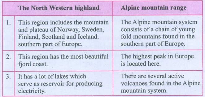
The North Western
highland
1. This region includes the mountain and plateau of Norway,
Sweden, Finland, Scotland and Iceland, southern part of Europe.
2. This region has the most beautiful fjord coast.
3. It has a lot of lakes
which serve as reservoir for producing electricity.
Alpine mountain
range
1. The Alpine mountain system consists of a chain of young fold
mountains found in the southern part of Europe.
2. The highest peak in Europe is located here.
3. There are several active volcanoes found in the Alpine mountain
system.
VII. Give Reasons
1. Asia
is the leading producer of rice.
Monsoon in Asia is suitable for rice
cultivation because of the abundant rainfall, fertile plains and availability
of labour.
2. Asia
is the largest and most populous continent in the world.
Asia is the most populated continent in the world. Approximately
six- tenth of the world's population lives in Asia.
Asia covers 30% of the world's land
area. As it lies in northern hemisphere it has varied physical features. The
mountains and perennial rivers are conducive to human existence. So it is the
largest and most populous continent in the world.
3. Europe
is called ‘a giant peninsula’.
Europe is surrounded by the Arctic
Ocean in the North, the Black Sea and Mediterranean Sea in the south, the
Atlantic Ocean in the west and the Ural mountains in the east. So it looks like
a giant peninsula.
4. Although
Western Europe is located in the high latitudes, it has a moderate climate.
North Atlantic Drift is a warm ocean
current which brings warmth to the western Europe. The westerly wind further
transports warmth across Europe. So Western Europe has a moderate climate.
VIII. Answer in Paragraph
1. Give
an account of the drainage system in Asia.
The rivers of Asia originate mostly
from the central highlands. The Ob, Yenise and Lena are the major rivers that
flow towards the north and drain into the Arctic Ocean. These rivers remain
frozen during winter. On the other hand, South Asia has many perennial rivers
(e.g.) Brahmaputra, Indus, Ganga and Irrawaddy which originate from the snow
covered high mountains that do not freeze during winter. The Euphrates and
Tigris flow in West Asia. The Amur, Huang He, Yangtze and Mekong rivers flow in
the south and south eastern parts of Asia. Yangtze is the longest river in
Asia.
2.
Describe the mineral sources found in Asia.
Asia has a variety of mineral deposits. It holds an important
place in the production of Iron, Coal, Manganese, Bauxite, Zinc, Tungsten,
Petroleum, Tin etc. Oil and Natural Gas is found in the west Asian countries.
One third of the world’s oil is produced in Asia. Among the west Asian
countries, Iran has a considerable wealth of mineral resources. The important
minerals found in Asia are:
Iron Ore : Asia has the largest deposits of iron ore in the world. China
and India are the important iron ore deposit countries of Asia. Turkey,
Philippines, Malaysia, Thailand, Myanmar etc., are a few other countries that
have iron ore deposits.
Coal : Coal is a fossil fuel. Asia has the largest deposits of coal in
the world. China and India are the largest producers of coal in Asia.
Petroleum : Petroleum is a mineral oil. The largest petroleum reserves are
found in South West Asia. The important petroleum producing countries are Saudi
Arabia, Kuwait, Iran, Bahrain, Qatar and UAE. South China, Malaysia, Brunei,
Indonesia, India, Russia are the other important petroleum producing countries
in Asia.
Bauxite is found in India and
Indonesia. India is the largest producer of Mica in the world. Tin is found in
Myanmar, Thailand, Malaysia and Indonesia.
3. What
are fjords? How do they protect harbours from bad weather conditions?
Fjord: A fjord is a narrow and deep sea inlet between steep cliffs. It
helps in the following ways.
1. It reduces the speed of wind, irrespective of its direction.
2. The force of sea waves are also controlled.
Hence, areas with fjords are best
suited for natural harbours.
4.
Describe the climatic divisions of Europe.
The climate of Europe varies from the subtropical to the polar
climate. The Mediterranean climate of the south has warm summer and rainy
winter. The western and northwestern parts have a mild, generally humid
climate, influenced by the North Atlantic Drift. In central and eastern Europe,
the climate is humid continental-type. In the northeast, subarctic and tundra
climates are found. The whole of Europe is subject to the moderating influence
of prevailing westerly winds from the Atlantic Ocean.
North Atlantic Drift is a warm ocean
current which brings warmth to the western Europe. The westerly wind further
transports warmth across Europe.
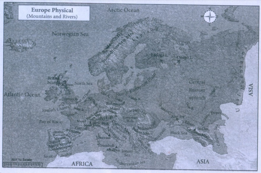
IX. Map Skill
Mark the following in the outline map of Asia
and Europe.
Asia: Ural mountain, Himalayas, Pamir knot, Gobi
Desert, Arabian Peninsula, Deccan plateau, River Yangtze, River Ob, Aral Sea
and Lake Baykal.
Europe: The Pyrenees, Black forest, Apennines, Hungarian Plain, Caucasus Mountain, River Volga, River Danube, Strait of Gibraltar, Lake Ladoga, North Sea
X. Activity
1. Complete the following.
I belong to ____ district. My district is famous
for the following: 1. ____, 2. ____ and 3. ____. The boundaries of my districts
are ____ in the north, ____ in the east, ____ in the south and ____ in the
west. It spreads for an area of ____ km2. There are ____ taluks and
____ villages in my district. ____, ____, ____ are the important mountain /
plain / plateaus (If all, mention all features). The rivers ____, ____, ____
criss – cross my district. ____, ____, ____ are common trees and wildlife such
as ____, ____, ____ are found here. ____, ____, ____ are important minerals
available in my district. Based on this ____, ____ industries are located here.
The major crops are ____, ____, ____. (Coastal districts may write the variety
of fish). The total population is ____. We celebrate ____, ____, ____
festivals.
2. If you get a chance to settle in Europe, which
country would you choose? List out the reasons why?
3. Choose any region is Asia. In the map of Asia,
mark its distribution of natural vegetation and wildlife.Paste related
pictures.
Related Topics