Geography - Atmospheric Disturbances (Cyclone and Anti Cyclone) | 11th Geography : Chapter 6 : Atmosphere
Chapter: 11th Geography : Chapter 6 : Atmosphere
Atmospheric Disturbances (Cyclone and Anti Cyclone)
Atmospheric
Disturbances (Cyclone and Anti Cyclone)
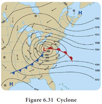
The atmospheric disturbances which involve a closed
circulation of air around a low pressure at centre and high pressure at
periphery, rotating anticlockwise in northern hemisphere and clockwise in
southern hemisphere is called ‘Cyclones’ (Figure 6.31). Cyclones may be
classified into two types based on latitude of its origin.
They are:
A. Tropical cyclone B. Temperate cyclone.
A. Tropical
Cyclone
Cyclone formed in the low latitudes is called as
Tropical cyclone. They form over warm ocean waters in the tropical regions. The
warm air rises, and causes an area of low air pressure.
Stages of Development of Tropical Cyclone
As per the criteria adopted by the World
Meteorological Organisation (W.M.O.),
India Meteorological Department classifies the low pressure systems in to vary classes based on wind speed.
1.
Tropical
Disturbances
2.
Tropical
depressions Low winds with a speed between 31 and 61 km ph.
3.
Tropical
cyclone wind speed from 62 to 88 km ph and it is assigned a name.
4.
Severe
Cyclonic Storm (SCS) wind speed is between 89 to 118 km ph
5.
Very
SCS wind speed between 119 to 221 km ph and
6.
Super
Cyclonic Storm when wind exceeds 221 km ph.
Origin
of Tropical Cyclone
Tropical cyclones have certain mechanism for their
formation. These are
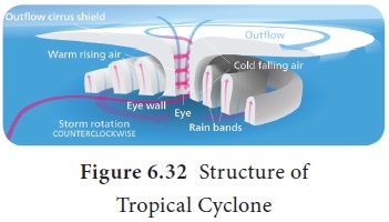
A source of warm, moist air derived from tropical
oceans with sea surface temperature normally near to or in excess of 27 °C
(Figure 6.32)
Wind near the ocean surface is blowing from
different directions converging and causing air to rise and storm clouds to
form.
Winds which do not vary greatly with height are known
as low wind shear. This allows the storm clouds to rise vertically to high
level;
Coriolis force is induced by the rotation of the
Earth. The mechanisms of formation vary across the world, but once a cluster of
storm clouds starts to rotate, it becomes a tropical depression. If it
continues to develop it becomes a tropical storm, and later a cyclone/ super
cyclone.
Characteristics of the Tropical Cyclone
The centre of the cyclone where the wind system
converges and vertically rises is called as Eye. The eye is a Calm region with
no rainfall and experiences highest temperature and lowest pressure within the
cyclonic system (Figure 6.32).
Cyclone wall is made up of Cumulo Nimbus clouds
with no visibility, higher wind velocity and heavy rain fall with lightning and
thunder.
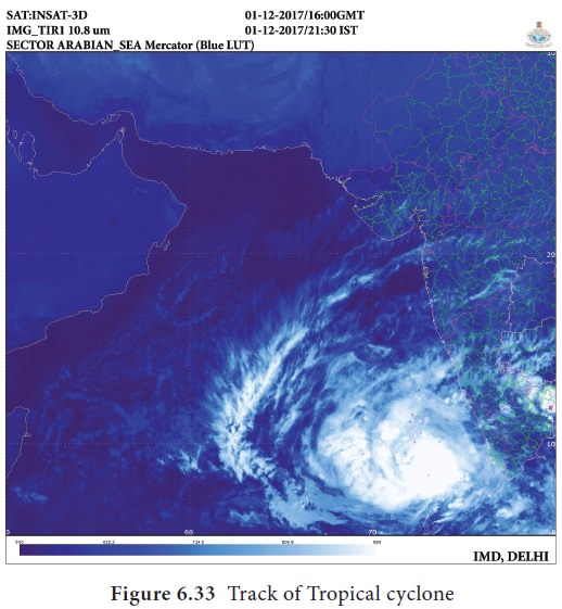
Tropical cyclones mostly move along with the
direction of trade wind system. So they travel from east to west and make land
fall on the eastern coast of the continents (Figure 6.33).
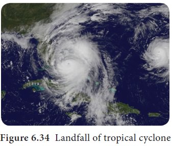
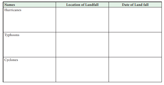
Landfall:
The condition at which the eye of the tropical cyclone crosses
the land is called ‘Land fall’ of the cyclone (Figure 6.34).
Naming of Tropical Cyclones
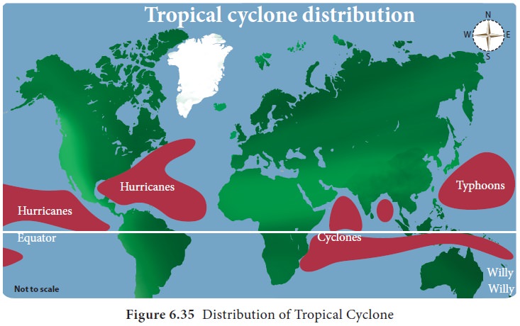
The practice of naming storms
(tropical cyclones) began years ago, in order to help in the quick
identification of storms in warning messages because names are presumed to be
far easier to remember than numbers and technical terms (Figure 6.35).
In the pursuit of a more organized
and efficient naming system, meteorologists later decided to identify storms
using names from a list arranged alphabetically. Since 1953, Atlantic tropical
storms have been named from lists originated by the National Hurricane Centre.
They are now maintained and updated by an international committee of the World
Meteorological Organization (WMO).
Large scale destruction caused by
Odisha cyclone in 1999, triggered the issue of naming tropical cyclones
developed in the North Indian ocean. As a result, naming conventions for storms
that develop in the Indian Ocean began in 2004. WMO (World Meteorological
Organisation)had informed each of the eight South Asian member countries to
submit a list of their own eight names for the cyclones.
Condition
of Super Cyclone Formation
Longer travel or stay of low pressure system over warm ocean water.
The speed of jet stream may influence the formation of super cyclone.
Tornado and Water Spouts
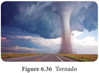
It is a very small intense, funnel shaped very speed whirl wind system. Its speed and direction of the movement are erratic (Figure 6.36). The winds are always as fast as 500 km ph. The fast moving air converges in the middle and rises up. The uplift is capable of rising dust, trees and other weaker objects in its path. South and western part of Gulf States of USA experiences frequent tornados.
Water spouts are formed over water
body similar to tornados in the formation and structure. This sometimes leads
to fish rain, if the mass of fish comes under the water spout.
B. Temperate Cyclone
The cyclone formed in the mid
latitudes is called as temperate cyclone. As they are formed due to movement of
air masses and front, they are called as ‘Dynamic cyclone’ and ‘Wave cyclone’.
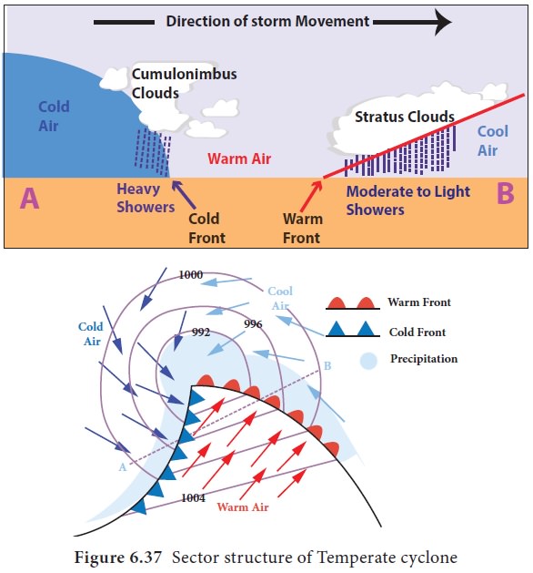
This cyclone is characterised by the four different sectors, which are varied
with their weather patterns (Figure 6.37).
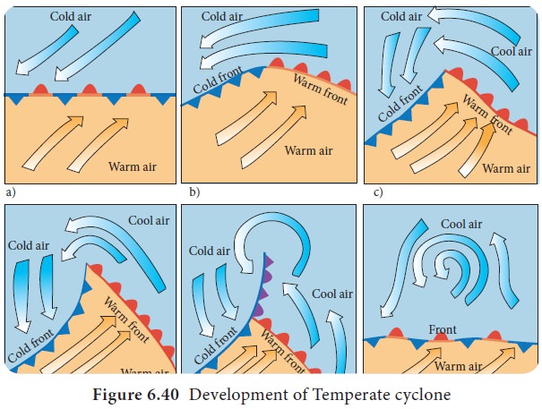
Stages in the Formation of Temperate Cyclone
1.
Frontogenesis –Formation of front due to collision of two contrasting
air masses (Figure ).
2.
Cyclone genesis – Formation of cyclone due to conversion of fronts into
various sectors.
3.
Advancing Stage – The stage where cold front advances towards warm
front.
4.
Occlusion stage - The stage where the cold front over takes warm front
5.
Frontalysis – The last stage where fronts disappear and cyclone ends its
life.
Characters
Unlike tropical cyclone, temperate cyclone forms
over both land and water in all seasons. It covers larger area than tropical
cyclone and stays for a longer period.
Track
Temperate cyclone moves along with the westerly
wind system from west to east.
Anti Cyclones
Anti cyclone is a whirlwind system in which high
pressure area at the centre and surrounded by low pressure at periphery
rotating clockwise in northern hemisphere and anti clock wise in southern
hemisphere(Figure 6.39).
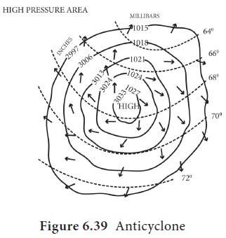
This is the largest among the whirl wind systems. Normally, they are associated with high pressure belts of sub tropical and polar region.
Anti cyclones are classified as warm core and cold
core, based on their temperature, which are resulted in aridity and cold waves
respectively.
Related Topics