Atmosphere | Geography - Air Masses and Fronts | 11th Geography : Chapter 6 : Atmosphere
Chapter: 11th Geography : Chapter 6 : Atmosphere
Air Masses and Fronts
Air
Masses and Fronts
The study of air mass is very
important part of Meteorology. Air always takes some of the properties of the
area over which it lies. This parcel of air may remain stationary for several
days and develops its own characteristics. Under this situation, the air
becomes recognisable as an air mass.
An air mass is defined as ‘an immense
body of air several kilometres in length and breadth and thickness which is
characterised by homogeneous physical properties (like temperature, moisture)
in horizontal direction at any level’.
Such an extensive portion of the
surface area over which air mass has acquired its qualities is called as ‘Air
mass source region’. The source region may be land or water body. For example,
Sahara desert, Siberia, the Great Plain of North America, Northern Plain of
Europe, Western Australia, Antarctica, Green Land, Arctic Ocean, Northern and
Southern Pacific, Atlantic Oceans are favourable locations as source region for
air masses.
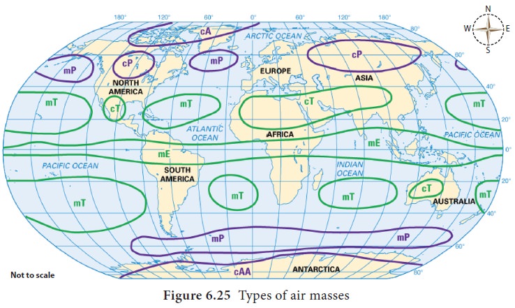
The air masses can be classified based on the following factors;
a.
Latitude - Tropical(T) and Polar (P) air masses
b.
Nature of the surface – Continent (c) and marine (m) air masses
c.
Temperature – warm (w) and Cold (k) air masses
d.
Stability – stable (s) and unstable (u) air masses
Air masses normally migrate from
their source region to other regions, which have different surface properties,
mostly along with primary winds. As the air masses move out from their source
regions, they not only modify the weather of the areas they occupy, but also
modify themselves according to the surface over which it moves.
Fronts
When two air masses with different
physical characters meet, there is usually
The zone of
transition between two contrasting air masses is called as ‘Fronts’. As heavier
air mass always tends to push up the lighter air mass, the front always slopes
over the cold air mass.
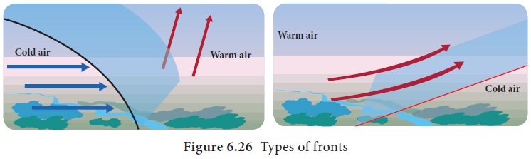
If cold air mass moves forward
rapidly and causes the warm air to rise vertically, it leads to the formation
of steep slope called as ‘Cold front’. Cold fronts result in the formation of
cumulo nimbus clouds with heavy rainfall associated with lightning and thunder.
If warm air is moving over cold air
mass, it produces a gentle slope called as ‘Warm front’. Warm fronts result in
the formation of stratus and nimbo stratus clouds and cover over large areas,
leading to moderate rainfall (Figure 6.26).
Related Topics