Chapter: Satellite Communication : Satellite Applications
INSAT or the Indian National Satellite System
INSAT:
INSAT or the Indian National Satellite System is a series of
multipurpose geo-stationary satellites launched by ISRO to satisfy the
telecommunications, broadcasting, meteorology, and search and rescue operations.
Commissioned
in 1983, INSAT is the largest domestic communication system in the Asia Pacific
Region. It is a joint venture of the Department of Space, Department of
Telecommunications, India Meteorological Department, All India Radio and
Doordarshan. The overall coordination and management of INSAT system rests with
the Secretary-level INSAT Coordination Committee.
INSAT
satellites provide transponders in various bands (C, S, Extended C and Ku)
to serve the television and communication needs of India. Some of the
satellites also have the Very High Resolution Radiometer (VHRR), CCD cameras
for metrological imaging.
The
satellites also incorporate transponder(s) for receiving distress alert signals
for search and rescue missions in the South Asian and Indian Ocean Region, as
ISRO is a member of the Cospas-Sarsat programme.
1. INSAT
System:.
The
Indian National Satellite (INSAT) System Was Commissioned With The Launch Of
INSAT-1B In August 1983 (INSAT-1A, The First Satellite Was Launched In April
1982 But Could Not Fulfil The Mission).
INSAT
System Ushered In A Revolution In India’s Television And Radio Broadcasting,
Telecommunications And Meteorological Sectors. It Enabled The Rapid Expansion
Of TV And Modern Telecommunication Facilities To Even The Remote Areas And
Off-Shore Islands.
2. Satellites In
Service:
Of
The 24 Satellites Launched In The Course Of The INSAT Program, 10 Are Still In
Operation.INSAT-2E
It
Is The Last Of The Five Satellites In INSAT-2 Series{Prateek }. It Carries
Seventeen C-Band And Lower Extended C-Band Transponders Providing Zonal And
Global Coverage With An Effective Isotropic Radiated Power (EIRP) Of 36 Dbw.
It
Also Carries A Very High Resolution Radiometer (VHRR) With Imaging Capacity In
The Visible (0.55-0.75 µm), Thermal Infrared (10.5-12.5 µm) And Water Vapour
(5.7-7.1 µm) Channels And Provides 2x2 Km, 8x8 Km And 8x8 Km Ground Resolution
Respectively.
INSAT-3A
The
Multipurpose Satellite, INSAT-3A, Was Launched By Ariane In April 2003. It Is
Located At 93.5 Degree East Longitude. The Payloads On INSAT-3A Are As Follows:
12
Normal C-Band Transponders (9 Channels Provide Expanded Coverage From Middle
East To South East Asia With An EIRP Of 38 Dbw, 3 Channels Provide India
Coverage With An EIRP Of 36 Dbw And 6 Extended C-Band Transponders Provide
India Coverage With An EIRP Of 36 Dbw).
A
CCD Camera Provides 1x1 Km Ground Resolution, In The Visible (0.63- 0.69 µm),
Near Infrared (0.77-0.86 µm) And Shortwave Infrared (1.55-1.70 µm) Bands.
INSAT-3D
Launched
In July 2013, INSAT-3D Is Positioned At 82 Degree East Longitude. INSAT-3D
Payloads Include Imager, Sounder, Data Relay Transponder And Search & Rescue
Transponder. All The Transponders Provide Coverage Over Large Part Of The
Indian Ocean Region Covering India, Bangladesh, Bhutan,Maldives, Nepal,
Seychelles, Sri Lanka And Tanzania For Rendering Distress Alert Services
INSAT-3E
Launched
In September 2003, INSAT-3E Is Positioned At 55 Degree East Longitude And
Carries 24 Normal C-Band Transponders Provide An Edge Of Coverage EIRP Of 37
Dbw Over India And 12 Extended C-Band Transponders Provide An Edge Of Coverage
EIRP Of 38 Dbw Over India.
KALPANA-1
KALPANA-1
Is An Exclusive Meteorological Satellite Launched By PSLV In September 2002. It
Carries Very High Resolution Radiometer And DRT Payloads To Provide
Meteorological Services. It Is Located At 74 Degree East Longitude. Its First
Name Was METSAT. It Was Later Renamed As KALPANA- 1 To Commemorate Kalpana
Chawla.
Edusat
Configured
For Audio-Visual Medium Employing Digital Interactive Classroom Lessons And
Multimedia Content, EDUSAT Was Launched By GSLV In September 2004. Its
Transponders And Their Ground Coverage Are Specially Configured To Cater To The
Educational Requirements.
GSAT-2
Launched
By The Second Flight Of GSLV In May 2003, GSAT-2 Is Located At 48 Degree East
Longitude And Carries Four Normal C-Band Transponders To Provide 36 Dbw EIRP With
India Coverage, Two Ku Band Transponders With 42 Dbw EIRP Over India And An MSS
Payload Similar To Those On INSAT-3B And INSAT-3C.
INSAT-4
Series:
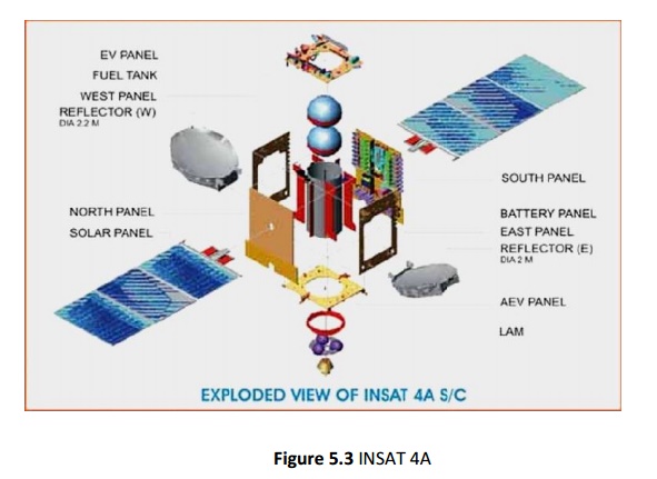
INSAT-4A
is positioned at 83 degree East longitude along with INSAT-2E and INSAT-3B. It
carries 12 Ku band 36 MHz bandwidth transponders employing 140 W TWTAs to
provide an EIRP of 52 dBW at the edge of coverage polygon with footprint
covering Indian main land and 12 C-band 36 MHz bandwidth transponders provide
an EIRP of 39 dBW at the edge of coverage with expanded radiation patterns
encompassing Indian geographical boundary, area beyond India in southeast and
northwest regions. Tata Sky, a joint venture between the TATA Group and STAR
uses INSAT-4A for distributing their DTH service.
INSAT-4A
INSAT-4B
Glitch In INSAT 4B
China-Stuxnet Connection
INSAT-4CR
GSAT-8 / INSAT-4G
GSAT-12 /GSAT-10
Related Topics