Geography - Atmospheric Pressure and Winds | 11th Geography : Chapter 6 : Atmosphere
Chapter: 11th Geography : Chapter 6 : Atmosphere
Atmospheric Pressure and Winds
Atmospheric
Pressure and Winds
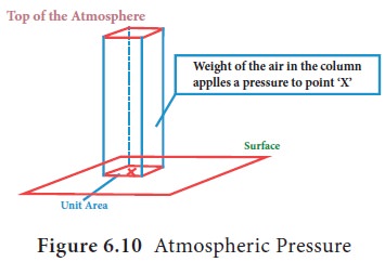
Atmospheric pressure is defined as the force per
unit area exerted against a surface by the weight of the air molecules above
the earth surface. In the Figure below (Figure 6.10), the pressure at point ‘X’
increases as the weight of the air increases. The atmospheric pressure is not
distributed uniformly over the earth. The amount of pressure increases or
decreases, according to the amount of molecules, that exerts the force on the
surface.
When temperature of the air increases, the air
expands and reduces the number of molecules over the unit area. It leads to
reduction in pressure. Similarly, when the temperature falls, the air contracts
and the pressure increase. Therefore, the temperature and atmospheric pressure
are inversely related.
Atmospheric pressure is measured by an instrument
called ‘Barometer’
Vertical Distribution of Atmospheric Pressure
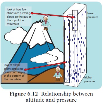
The relationship analysis between altitude and
atmospheric pressure is very peculiar. The upper atmosphere is thin and less
dense. The pressure at sea level is highest and keeps decreasing rapidly with increasing
altitude because of the progressive reduction of the mass above the point where
it is measured (Figure 6.12).
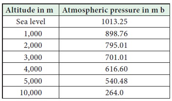
Relationship between Standard Pressure and Altitude
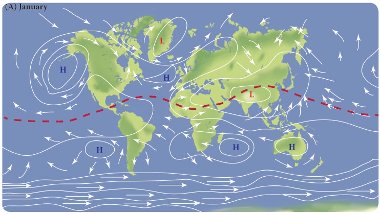
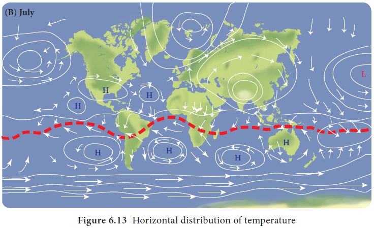
Horizontal
Distribution of the Atmospheric Pressure
When the air gets heated it expands, becomes light
and rises vertically. As air rises, the pressure it exerts on the earth surface
is reduced, causing a low pressure area (Figure 6.13).
On the other hand, cool air is dense and heavy. As
a consequence it sinks
Coriolis Effect
The rotation of the earth affects the moving objects on the earth surface. Free moving objects, affected by the rotation of the earth, do not follow a straight line. In the northern hemisphere they drift towards right and towards left in the southern hemisphere. A car travelling down a straight road at 95 km/hr in northern hemisphere would drift to the right of the path if the friction between surface and tyre is absent. The tendency is called as Coriolis Effect as it was discovered by Coriolis. This is the reason why racket launching stations are located on the east coastal areas. Example: Sriharihota, French Guyana.
Pressure Belts of the Earth
The atmospheric pressure belts envelope on the
surface of the earth. They are equatorial low pressure belt, sub tropical high
pressure belts, sub polar low pressure belts and polar high pressure belts
(Figure 6.13).
Wind Systems
Wind is the horizontal movement of air molecules
from areas of high pressure to areas of low pressure to maintain the
atmospheric equilibrium. The wind always moves perpendicular to isobars. If the
earth did not rotate, the winds would blow in a straight path. Then the
rotation of the earth results in corilois effect and it deflects the direction
of the wind. Wind direction is identified by an instrument called Wind Vane and
wind speed is measured by Anemometer.
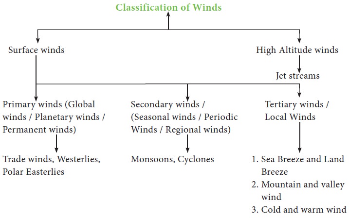
Types of Winds
Winds are classified based on the nature and area
of influence as follows;
General Atmospheric Circulation, Pressure Belts and Primary Wind System
From the equator
to the poles,
each hemisphere has four pressure belts and totally there are seven
belts on the globe. The pressure belts lead to formation of primary wind system
as follows (Figure 6.14):
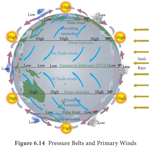
a. The
equatorial low pressure belt (between 58oN
and 58oS):
This is the region of calm, weak and changeable winds. Due to the high
temperature over this region, the air gets heated expands and become lighter
and rises upward and creates low pressure over the region. This region is a
belt of calm and referred to as the ‘Doldrums’. The winds blow from the sub
tropical high pressure belt towards the equatorial low pressure belt. Due to
Coriolis Effect these winds are deflected to the right in the northern
hemisphere and to the left in the southern hemisphere. As winds are named after
the direction from which they originate they are called as the North East and
South east trade winds. As the winds favoured trading ships they are called as
‘Trade winds’.
b. The
sub tropical high pressure belt (25o to 35o N and S): Air begins to cool when it reaches higher altitude
over equatorial region and flows towards the poles. This wind collides with the
wind coming from the polar region at higher altitude and subsides down over sub
tropical latitudes. This leads to formation of high pressure belt along the sub
tropical region. It is said that to avoid the slowing down of ship due to high
pressure the horses were thrown into the sea. So this belt is called as ‘Horse
latitude’. The sinking air bifurcated in to two branches towards the equator
and poles, they are called as trade winds and westerly respectively. Westerlies
flow towards the pole from sub tropics and turn towards right and left in
northern hemisphere and southern hemisphere respectively.
c. The
sub polar low pressure belt (50o to 60o N and S): The warm westerly wind from sub tropical region moves
towards the pole and collide with the cold polar easterly wind from polar high
pressure region and raises up to form sub polar low pressure belt.
d. Polar
high pressure belt (80o N and S to pole): The constant low temperature at the poles due to
inclined solar radiation and reduced insolation leads to the formation of polar
high pressure belt on both poles.
The high pressure on the surface
always coincide with the low pressure at higher altitude while the low pressure
on the surface always coincide with higher pressure on the higher altitude.
High pressure always has divergence of air masses from the centre but low
pressure has convergence of air.
Basis of Formation of Pressure Belts
There are two important bases on
which the pressure belts are formed. They are;
a. Temperature: The equatorial low
pressure and polar high pressure belts are formed due to high and low
temperature respectively. So they are called as ‘Thermally formed pressure
belts’.
b. Dynamism: The sub tropical high
and sub polar low pressure belts are formed due to movement and collision of
wind system. So they are called as ‘Dynamically formed pressure belt system’.
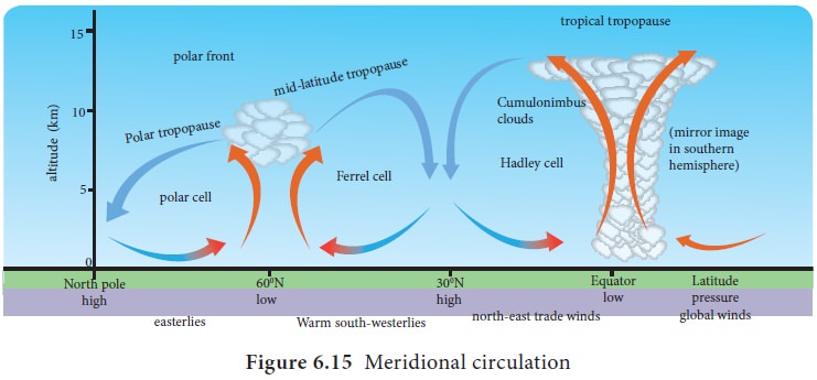
Meridional Cell System
The cell along with trade winds,
equatorial low and sub tropical high pressure belts is called as ‘Hadley cell’,
meanwhile the cell formed by westerly wind along with sub tropical high and sub
polar low pressure belt is called ‘Ferrell’s cell’. The cell at polar formed by
polar easterlies with polar high and sub polar low pressure belt is called as
‘Polar cell’ (Figure 6.15).
ITCZ – Inter Tropical Convergent Zone
The region where both trade wind
systems meet is known as ‘Inter Tropical Convergent Zone’.
Shifting of Pressure Belts and Primary Wind System
These pressure belts and primary wind
systems are dynamic in character as they shift 5° north and 5° south from their position along with the apparent movement
of the sun.
Secondary Wind System
Both monsoon and cyclones are
considered as secondary or regional wind systems.
Monsoons
The word ‘Monsoon’ is derived from
the Arabic word, ‘Mausim’ which means ‘Season’. Monsoons are seasonal winds
which reverse their direction due to unequal heating and cooling of the land
and the water.
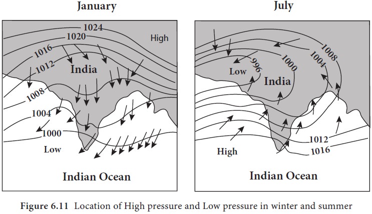
Mechanism of Monsoon
The land absorbs more heat energy during summer, which leads to the formation of low pressure over continent. But the ocean will have relatively lower temperature than the continent leading to the formation of high pressure system over ocean. So, the wind blows from sea to land during summer season.
Meanwhile the land reradiates more heat energy to space during
winter leading to the formation of high pressure above the continent. But the
ocean will have relatively higher temperature than the continent leading to
formation of low pressure system over ocean. So, wind blows from land to sea
during the winter season. This mechanism has an important effect on rainfall
received over the region.
Nature of Monsoon System
There are three distinct
characteristics related to monsoon wind system which differentiates it from
other wind systems. They are;
a. Minimum 1608 reversal of wind direction between seasons.
b.
They affect a large part of the continents and oceans.
c.
The formation of low and high pressure systems over land and water and
their interchange between the seasons.
Monsoon system is classified into two
groups based on the location. They are;
a.
Asian Monsoon
b.
South Asian Monsoon
a. Asian Monsoon
The Asian monsoon system is divided into two components based on season it flows. The presence of high temperature with low pressure in the lake Baikal region and low temperature with high pressure in the Aleutian islands region leading to flow of wind from Pacific Ocean to interior part of Asia during summer is called ‘Summer Monsoon of Asia’. This leads to rainfall in the east coast of Asia.
Meanwhile, in winter the low
temperature and high pressure in the Lake Baikal region and high temperature
and low pressure in the Aleutian Island region leading to flow of wind from
Central Asia to Pacific Ocean is known as ‘Winter Monsoon of Asia’. As the wind
system flows off shore, the rainfall does not occur in the continent of Asia
except western coast of Japan.
b. South Asian Monsoon
South Asian Monsoon includes the
countries in the southern part of Himalayas, that is India, Pakistan, Bangladesh,
Sri lanka, Maldives, Nepal and Bhutan. This monsoon system has been classified
into two groups based on the direction of origin of wind namely south west
monsoon and north east monsoon (Figure 6.16).
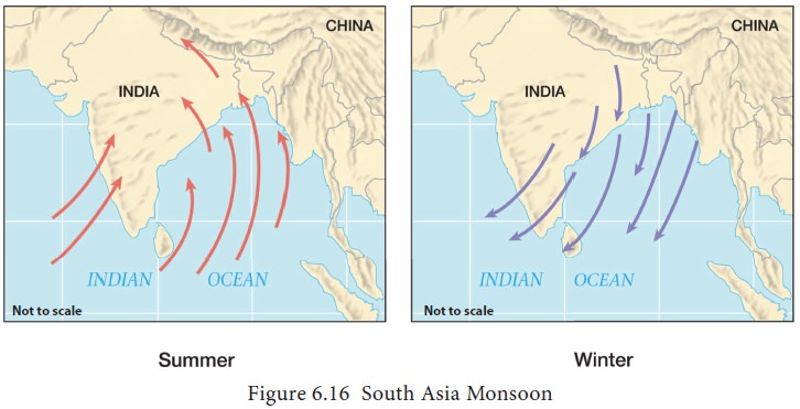
South West Monsoon
During summer the Indian peninsula is
heated more than the sea around it. Intense low pressure is formed in the
region of Peshawar of Pakistan. At the same time, the Indian Ocean has higher
pressure due to relatively low temperature. So the wind blows from Indian Ocean
towards South Asia as Southeast Winds. The wind turns towards right due to
Coriolis Effect and blows as south west winds which bring heavy rains around
four months of the year. This is known as south west monsoon in Indian Sub
continent. This wind system bifurcates into two branches as Arabian Sea branch
and Bay of Bengal branch.
Arabian Sea Branch
The Arabian Sea branch strikes the
Western Ghats at perpendicular direction and rises over it. The orographic
effect by the Western Ghats results in heavy rainfall in the windward side and
low rainfall in the leeward side. So the west coast of India receives high
rainfall when compared to the eastern side of the Western Ghats. Kerala is the
first state to receive rainfall from the south west monsoon in India, which
occurs during first week of June. Then, the wind gradually moves towards the
north of the western coast and leads to gradual development of the monsoon in
parts of Karnataka, Goa, Maharashtra, Gujarat and Rajasthan. The wind further
advances towards foot hill of the Himalayas and creates orographic rainfall in
the Himalayan states, Punjab and Haryana. The other part of the Arabian Sea
branch moves towards the east and results in onset of monsoon in Uttar Pradesh
and Bihar. Here, it unites with the Bay of Bengal branch and leads to heavy
rainfall and flood.
Bay of Bengal Branch
Bay of Bengal branch flows from south
west which results in orographic rainfall in Sri Lanka and reaches Andaman and
Nicobar Islands and results in orographic rainfall. Indira point in the Great
Nicobar is the first place which receives rainfall during south west monsoon in
India during middle of May. The wind flows parallel to the east coast of India
and Eastern Ghats. So Coromandel Coast of India doesn’t get enough rainfall
during south west monsoon. The wind strikes Arakanyoma Mountain in Myanmar and
results in heavy rainfall in western coast of Myanmar. The wind funnels towards
north eastern part of India after deflected by the Arakanyoma Mountain in
Myanmar. This wind strikes Meghalaya plateau which leads to heavy rainfall in
Bangladesh and North eastern part of India. Mawsynram, the wettest place
(highest annual rainfall) in the world, is located in the windward side of
Meghalaya plateau.
The wind further advances towards the
Himalayas where it creates heavy rainfall in the southern slopes. This leads to
flood in River Brahmaputra. The wind gradually moves towards the west and
results in onset of monsoon in Bhutan, Sikkim, West Bengal, Nepal and Bihar. It
joins with Arabian Sea branch in Bihar and results in heavy rainfall and flood.
The south west monsoon gradually
withdraws from south Asian continent due to apparent movement of the Sun
towards the southern hemisphere. This is called as ‘Withdrawal of South West
Monsoon’.
North East Monsoon
During winter the Indian Subcontinent
becomes colder than the Indian Ocean. As a result the wind blows from Northeast
to South West direction. This is dry wind system and it does not produce
rainfall in the coastal region of south Asia except the Coromandel Coast of
India and Sri Lanka.
Mawsynram, world’s wettest place!
‘’It was the kind of rain you wouldn’t see anywhere else. We could
barely see four feet ahead of us. We could touch the clouds, smell the clouds,
and taste the clouds’’ said a local resident. Yes, it is about Mawsynram which
is located in Meghalaya’s East Khasi Hills, with the cluster of about 1,000
homes. It holds the Guinness Record for “the wettest place on earth”. The
average annual rainfall is 11,861mm, according to the Guinness website.
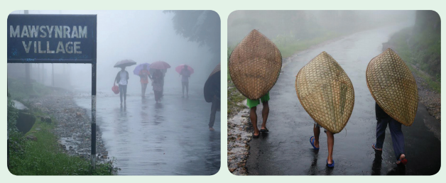
However, the soil in the limestone plateau doesn’t absorb water. “There is barely any forest cover, so a lot of erosion of top soil happens. All of it flows down into Bangladesh. The irony is that “the wettest place on earth” grapples with an acute water shortage after monsoon ends around October. Hence, people call world’s rainiest place Mawsynram, which is also world’s wettest desert.
This is known as North East Monsoon
or Retreating Monsoon in South Asia.
Agriculture in India mostly depends
on the rainfall brought by the monsoons.
During the El Nino year the
temperature of the ocean water increases. This weakens the high pressure over
Indian Ocean thereby reduces the strength of south west monsoon over south
Asia. However during winter, it induces the low pressure over the ocean
resulting in severe depressions and cyclones.
Tertiary Winds
The tertiary winds are formed due to
pressure gradients which may develop on a local scale because of differences in
the heating and cooling of the earth’s surface.
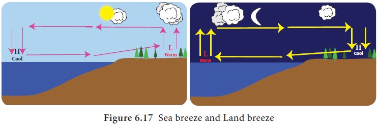
Sea and Land Breezes
During daytime, land heats up much
faster than water. The air over the land warms and expands leading to form low
pressure. At the same time, the air over the ocean becomes cool because of water’s
slower rate of heating and results in formation of high pressure. Air begins to
blow from high pressure over ocean to the low pressure over the land. This is
called as ‘Sea breeze’. During night time, the wind blows from land to sea and
it is called as ‘Land breeze’ (Figure 6.17).
Sea breeze and land breeze influence
the movement of boats near
the coastal region and
fisher men use these winds for their daily fish catching.
Fishermen go for fishing at early morning along the land breeze and return to
the shore in the evening with the sea breeze.
Mountain and Valley Breezes
A valley breeze develops during the
day as the sun heats the land surface and air at the valley bottom and sides.
As the air gets heated it becomes less dense and begins to blow gently up the
valley sides. This is called as ‘valley wind’. This process reverses at night
leading to blow of wind from mountain top to valley bottom referred to as
‘mountain wind’ (Figure 6.18).
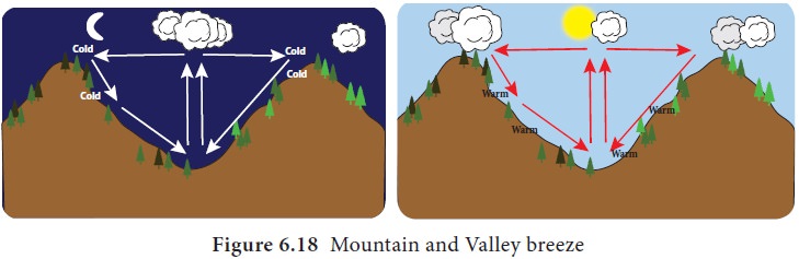
Mountain and valley wind systems influence the weather pattern of the
mountain top and valley bottom.
Mountain top can be seen clearly at early morning and valley bottom at
evening. But mountain top will be covered with clouds at evening due to rising
of valley wind system and valley bottom would be covered by clouds at early
morning due to arrival of mountain wind system. These clouds are sometimes
called as ‘fog’ which is used for cultivation in the dry regions like Yemen.
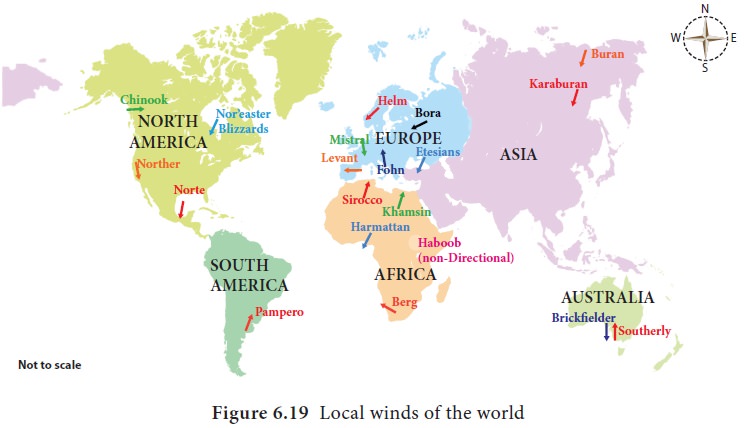
Local Winds
Local wind systems influence the
weather pattern where ever they blow (Figure 6.19). Some important local winds
are;
Bora: North easterly from eastern Europe to north eastern Italy
Chinook:
Warm dry westerly
off the Rocky Mountains
Fohn: Warm dry southerly off the northern side of the Alps and
Switzerland.
Harmattan:
Dry northerly wind
across central Africa
Karaburan:
‘Black storm’ a
spring and summer katabatic wind of central Asia
Khamsin:
South easterly from
North Africa to the eastern Mediterranean
Loo: Hot and dry wind which blows over plains of India and Pakistan.
Mistral: Cold northerly from central France and the Alps to Mediterranean.
Nor’easter: Strong winds from the northeast in the eastern United States, especially
New England
Nor’wester: Wind that brings rain to the West Coast, and warm dry winds to the East
Coast of New Zealand’s South Island, caused by the moist prevailing winds being
uplifted over the Southern Alps, often accompanied by a distinctive arched cloud
pattern.
Pampero: Argentina, very
strong wind which blows in the Pampa.
Simoom: Strong, dry, desert
wind that blows in the Sahara, Israel, Jordan, Syria, and the desert of Arabia.
Sirocco: Southerly from
North Africa to southern Europe.
Zonda wind: On the eastern slope of the Andes in Argentina.
Jet Streams
Jet streams are high altitude westerly wind system blows at a height of 6 to 14 km, with very high speed up to 450 km/h in wavy form at both hemispheres. As they encircle the poles they are called as ‘Circum polar wind system’ (Figure 6.20).
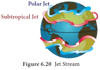
Although the jet streams flow at
higher altitude they also influences the surface weather pattern of the Earth.
The Major impacts of Jet streams
1. Creation
of Polar vortex: Polar westerly jet stream will carry cold polar air masses towards temperate
region which creates severe cold waves in North America and Eurasia during
winter.
2. Sudden
burst of South west monsoon:
Sudden withdrawal of polar westerly
jet stream from Indian sub continent to northern part of Pamir, leads to sudden
burst of South west monsoon into Indian Sub continent.
3. Late
and early monsoon in South Asia: Rate of with drawl of polar westerly jet stream decides the onset of south west monsoon. Slower and
faster rate of with drawl leads to late and early onset of south west monsoon.
4. Intensity
of monsoon rainfall: The arrival of tropical easterly jet stream influences the intensity of
south west monsoon. This leads to increasing intensity of rainfall during south
west monsoon.
5. Bringing
rainfall to India by western disturbances: Polar westerly jet stream carries rainy clouds from cyclones formed
over Mediterranean Sea during winter towards India. These clouds piles up on
the Himalayas and results in rainfall over the states of Punjab and Haryana.
This assists in the cultivation of wheat in India.
6. Development
of super cyclone: The condition at which the speed of the jet stream is transferred to
tropical cyclone may leads to development of super cyclone.
Related Topics