The Summit | Prose | By Edmund Hillary - Writing | 12th English : UNIT 4 : Prose : The Summit
Chapter: 12th English : UNIT 4 : Prose : The Summit
Writing
Writing
Summarizing
Summarizing is to briefly sum up the various points from the notes made from the original passage.
Refer the reading passage. You must have completed reading. Now go through the passage once again and refer to the notes made and do the summarizing.
Interpreting non–verbal presentation
You have already learnt to present information or data in a visual form through tables, graphs etc. Map reading also falls under this category. Now let us interpret a map as a part of non–verbal presentation.
Reading a map
Nowadays though locations are traced easily using GPS, (Global Positioning System) one should know what to look for in the map to reach the destination. Here are a few general instructions to be followed while reading a map.
1. Identify and understand the elements of the map correctly.
2. Look out for the title to know what the map shows.
3. Study the symbols / colours that are used on the map and find what they stand for.
4. Look at the scale of the map. (whether to be scaled or not to be scaled)
5. Look for the pointer to know the direction.
Let us together scale the summit. Here is a drawing of the Everest showing the way to the summit, and the position of the camps with their heights. Trace the trekking trail to reach the summit with the given details and write an interesting paragraph in about 100 words.
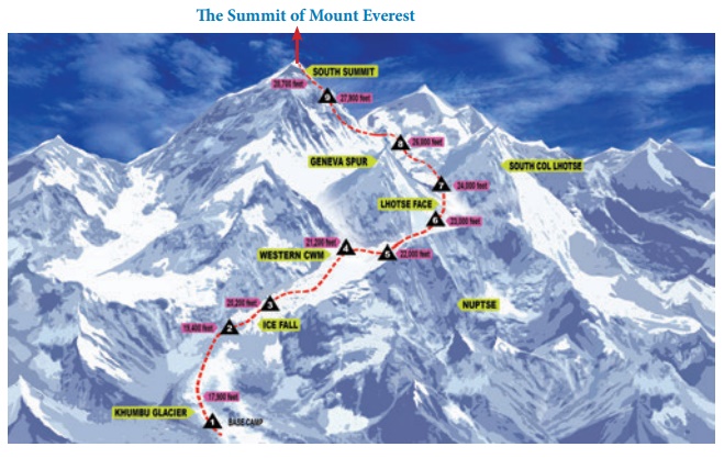
1. The map shows Mt.Everest, several important parts of the Himalayas are marked. White colour indicates soft - snow. It is dangerous. The mountaineer will slip and come down. Black indicates hard snow. The mountaineer can climb without any risk.. There are rune camps where the mountaineers can stop for a while, refresh themselves and they proceed.
2. The following titles suit the map.
• The cloud - capped summit • The snow - covered mountain • The Ambition of the Mountaineers • The conquest of the Everest • Reaching towards the Sky
3. The white colour means “soft - snow”. It is slippery and dangerous. The mountaineer may slip down.
Black snow means hard snow. It is not dangerous. The numbers indicate camps where the mountaineers can stop and refresh themselves. The line marks the route of the mountaineers.
4. The map is not drawn to scale. There is no legend at the bottom of the map.
Legend = written explanation of a map
Shorter oxford Dictionary
Volume 1 P.1569
Interesting paragraph about trekking trail to reach the summit
We started our journey at the base camp. We have sufficient oxygen with us. At the 3rd camp, we suffered a lot due to ice fall. We didn’t came out till the weather was clear. Only three of our team could reach the 8th camp. From here the ridge narrowed to a knife-edged and it was steep slope. So we had to cut steps and then moved. Since there were lot of firm snow, we could do it. With great efforts. We reached the 9th camp. One of my friends became sick, I started my challenging journey with my other friend. Having fierce determination, nothing could stop us reaching the top. When we realized that the ridge ahead of us dropped sharply away, we stood on the summit. It was a splendid joy we shared each other and shouted, at the height of 28,700 feet.
Related Topics