Term 3 Unit 1 | Geography | 7th Social Science - North America - Exploring Continents | 7th Social Science : Geography : Term 3 Unit 1 : Exploring Continents -North America and South America
Chapter: 7th Social Science : Geography : Term 3 Unit 1 : Exploring Continents -North America and South America
North America - Exploring Continents
North America - Exploring
Continents
North
and South America are often referred to as the new world because they were
discovered in the late fifteenth century. In 1492 North America was discovered
by Christopher Columbus while he wastrying to find a new sea route to India.
The landmass was named America in 1507 after the Italian explorer America
Vespucci who landed on the continent. In this lesson we can learn location,
boundaries, relief features rivers climate natural vegetation, minerals and
transportation.
Location and Area
The
continent of North America lies between 7°N and 84°N latitudewhich lie entirely
in the Northern Hemisphere. The Tropic of Cancer (23 ½°N) passes through the
Mexico and Arctic Circle (66 ½°N) runs through northern part of Canada.
Longitudinally it extends between 53°W and 180°W and lies entirely in the
western hemisphere. This continent has a great longitudinal extent which
results in Seven Time Zones. North America covers an area of about 24,709,000
Sq. km. Which occupies 16.50 percent of the entire land area.
Boundaries
North America is surrounded by the
Pacific Ocean in the West, the Atlantic Ocean in the east, Arctic Ocean in the
north and South America in the south. The North America is joined with the
South America by the Isthmus of Panama. The Bering Strait separates North
America from Asia.
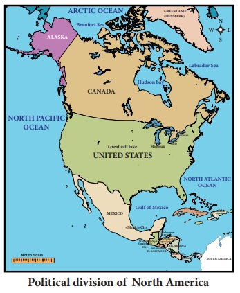
Political Division
North America is the third largest
continent next to Asia and Africa. North America has three large countries and
several smaller ones. Canada is largest country of North America followed by
the United States of America and Mexico. The seven small countries which lies
to the south of Mexico are referred to as central America. These include
Nicaragua, Honduras, Guatemala, Panama, Costa Rica, El Salvador and Belize.\
Isthmus : A narrow stretch
of land joining two largeland masses.
Strait: A narrow stretch
of water joining two large water bodies.
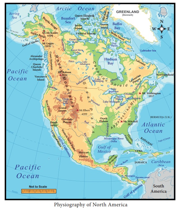
Physiography
North
America is a continent of great physical diversity. Mount McKinley is about
6194 m above the sea level and is the highest peak. Death Valley is about 86 m
below the sea level and is the lowest part of the continent of North America.
It has some of the oldest and the youngest rocks in the world. On the basis of
physiography North America can be classified into the following physical
divisions:
1. The Rocky Mountains,
2. The Great Plains,
3. The Appalachian Highlands and
4. The Coastal Plain.
1. The Rocky Mountains
The
western part of the continent is occupied by long ranges of young folded
mountains interspersed with high plateaus, narrow valleys and broad interior
basins. This mountain range extends for about 4800 km from Alaska in the North
to the Panama Strait in the South. The width varies from 110 to 480 Kms. They
are parallel ranges and are known as the Rockies in the east and the Coast
Range Mountains in the west. The Sierra Nevada is a mountain range in the
Western United States between the Central Valley of California and the Great
Basin. In Mexico, they are called Sierra Madre. The Rockies and the Coast Range
are together called the “Western Cordilleras”. There are high inter montane
plateaus between the ranges. The prominent ones are the Mexican plateau, the
Colorado Plateau and the Columbian plateau.
The Cordilleras are also
part of the Fire Ring of the Pacific because there are a number of active
volcanoes and this area is also subject to earthquakes.
Highest peaks in different continents:
•Asia: Mount Everest (8848
meters)
•South America: Mount
Aconcagua (6961 meters)
•North America: Mount
McKinley (6194 meters)
•Africa: Mount Kilimanjaro
(5895 meters)
•Europe: Mount Elbrus
(5642 meters)
•Antarctica: Mount Vinson
Massif (4,892meters)
•Australia: Mount
Kosciuszko (2,228 meters)
The Great Plains
To
the east of the Rockies and the west of the Appalachian Mountains lies the
great plains of North America. It covers about three - fifth of the continent.
This plain stretches from the Arctic Ocean in North to the Gulf of Mexico in
the South and from the Appalachian Highlands in the east to the Rockies in the
west. The western part of the plains is called the High Plains spreading
roughly over the foothills of the Rockies. Most of the rivers of this region
have their source in the Western Highlands and the plains generally slope
eastwards and southwards. They are drained by rivers like the Mississippi and
the Missouri.
The Appalachian Highlands
The
Appalachian Highlands do not form a continuous chain like the Western Highlands
(The Rockies). These Highlands are low and wide. They have a very few peaks
more than 1800m. They include the High Plateaus of Greenland, Labrador or
Laurentian Plateau in Canada and the Appalachian Mountains in the United
States. These old fold mountains are worn down by weathering and are much lower
than the Western highlands. This region is rich in mineral reserves like coal,
iron ore, copper etc., which play a vital role in the North American economy.
The Coastal Plains
The
coastal plains of North America are the youngest in age. Most of the Atlantic
Plain has been drowned (lies underwater). This is low and relatively plain area
with sandy soil which is infertile in nature. Here swamps and marshes are
abundant and the coast is indented by river mouths and bays on which many
important seaports are located.
Drainage
Many
rivers flow across this land and some of them following the valleys are formed
by the glaciers. The Mississippi and Missouri rivers are the longest rivers in
North America and together they form the fourth longest river system in the
world and stretching more than 6114 km from Montana to Gulf of Mexico. After
3700km running the Missouri river joins the Mississippi river. The Mackenzie
River is the second largest drainage basin of North America. It has it source
from Great Slave Lake and drains into Arctic Ocean.
St.
Lawrence has its origin in Lake Ontario which flows north east and drains into
the Atlantic Ocean. The plateau of the west has been cut deeply by the River
Columbia and its tributary which forms many Gorges called Canyons. The most
famous is the Grand Canyon cut by the river Colorado which all flows over the
plateau of Columbia. These rivers form a barrier to communication but whose
water has been dammed for irrigation and power. The River Yukon rising in the
north-west of the Western mountain system is frozen for eight months in the
year. The River Rio Grande flows into the Gulf of Mexico and forms the boundary
between USA and Mexico.
Grand Canyon is a steep-sided
Canyon carved by the Colorado River in Arizona State of USA
Numerous lakes are found in the
glaciated parts of the continent and especially in North Minnesota. These lakes
are small and they are used for recreational purposes. The Great Lakes are
formed across the continent from west to east. The most important chain
consists of five lakes. The biggest is Lake Superior and it is the largest
freshwater lake in the world. Lake Winnipeg, Great Bear Lake and Lake Athabasca
are some of the other lakes in Canada.
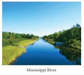
The Mississippi river has been given the nickname “The Big Muddy”
because iterodes a lot of sand and mudas it rushes down the Mountains.
Some of the States of the United States are named after the
tributaries of two mighty rivers the Mississippi and Missouri.
Climate
The vast latitudinal extent from the
Tropics to the Polar Regions makes the climate of North America as varied as
that of Asia. Unlike the Himalayas, the Rockies run north to south which do not
form climatic barrier and do not prevent the icy winds from the Arctic region
and penetrating the central plains which therefore have a very long cold winter
and very short hot summer. Precipitation occurs due to cyclonic storms. The
Arctic region is cold and mostly dry and has a very short summers and a very
long bitterly cold winter. As one proceeds southwards the short summers become
warm but the winters are very cold. The central plains have extreme climate
from freezing conditions in winter to tropical heat in summer.
The South is usually warm all the
year round and the regions around the mouth of the Mississippi-Missouri and the
Gulf Coast have summer rain from the North East Trades which blow on-shore in
summer. The warm moist South Westerlies not only bring rainfall to the North
West coast and also keep it warm. The warm Alaskan Current keeps the North West
coast ice free. The State of California in USA has a Mediterranean Climate with
moist winter and dry summers.
The Westerlies or Anti- trades
are prevailing windsfrom the west toward theeast in the middle latitudesbetween
30 and 60 degrees latitude.
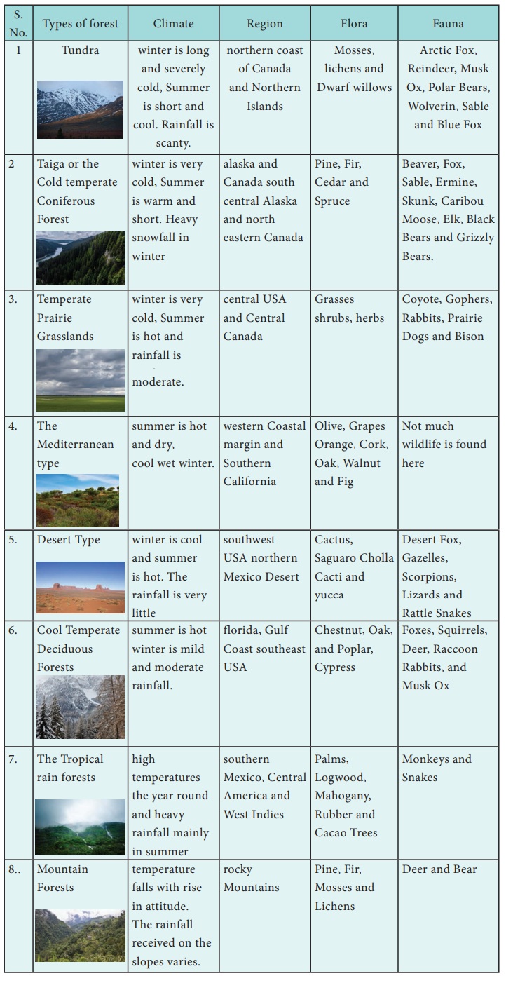
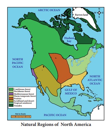
Natural Vegetation
North America is endowed with a
diverse and extensive forest cover. Approximately 30 percentage of the total land area
is under forest cover. Lumbering is a well developed industry particularly in
Canada. North America is a major producer of timber, plywood, wood pulp and
paper. It accounts for approximately 20 percentage of the world's production of
timber. This diversity is brought about primarily because of the different
latitudes and variations in altitude, soil and precipitation.
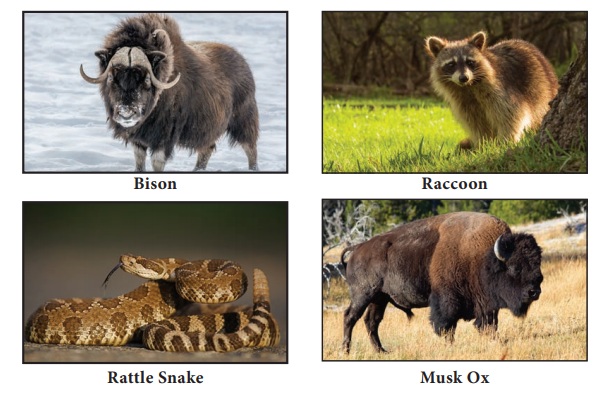
Forest, Flora and Fauna of different regions of North America
Agriculture
Though least proportion of the total workforce is engaged in agriculture. America's agriculture is most productive in the world. Extensive agriculture system is practiced in Canada and USA. Both Canada and USA are the major exporter of wheat than the other countries of the world. Wheat, Corn (Maize), Oats, Soybean, Barley and many other food crops are grown throughout the vast interior plains.
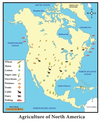
Wheat
Wheat was introduced by European
settlers in North America. It is grown extensively in the Prairies of North
America. North America is the largest exporter of wheat. Vast wheat producing
area are called wheat belt.
Maize
It is the Native Food Crop of North
America which is the main staple food grains in Mexico. It is grown in southern
Prairies. North America produces more than half of the world total Maize.
Barley and Oats
These are temperate crops which
withstand cold climate and need less water. The Barley is grown in the United
States and are produced in Minnesota, North Dakota and Washington. Barley and
Oats is used as cattle fodder.
Cotton
Cotton grows well in Southern and
Western States and it is dominated in Texas, California, Mississippi, South of
the Prairies and the Mexico. Warm summer with frequent rainfall and fertile
soil are favourable conditions for growth of cotton crop.
Sugar cane
Sugar cane is cultivated along the
Gulf of Mexico, Parts of Central America and West Indies. It is an important
Cash Crop of West Indies. Cuba is known as the “sugar bowl of the world” and it
is the world's largest exporter of sugar.
Soya beans
It is raised in the same area where
Maize is grown. It is used for extraction of edible oil.
Potatoes and Sugar
beet
Prairie Region, North Dakota and Minnesota
are the producers of Sugar Beets and Potatoes. Sugar beet is used for making
Sugar. Potato and Sugar Beet are used to feed cattle and pigs.
Fruits
Mainly Citrus Fruits are cultivated
in Texas, California, Great Lakes regions and St. Lawrence Valley. The
important Fruits of North America are Cranberries, Blueberries, Concord Grapes,
Strawberries, Gooseberries and the other fruits.

Cattle rearing
Cattle rearing are carried on a
commercial scale in the drier parts of the Prairies in the south Western part
of United States. Vast herds of Cattle and Sheep are kept on large Ranches.
Richer pastures are used for cattle and poorer sparse pastures are used for
sheep. North America is the largest producer of meat and about one fourth of
the world production.
Dairy farming
Dairy farming refers to rearing
cattle for milk. It is an important industry of USA and Canada. Dairy farming
is found in the cooler and humid part of the Prairies, Great Lakes areas and
north east region along the Atlantic coast. North America produces about 25
percent of the world total milk and dairy products.
Fisheries
Fishing is locally important in the
seas around the continent. Grand bank is one of the world's best fishing
grounds. It is located in the island of Newfoundland in Canada. Here the
meeting of Cold Labrador current and Warm Gulf Stream current provides suitable
condition for fish to thrive. The cold Labrador Current brings plenty of
plankton which provides food for fish. Cod, Herring, Mackerel, Salmon and
Halibut are the major varieties of fish in North America.
Grand Banks: The Grand Banks is among the world's largest and
richest resource areas, renowned for both their valuable fish stocks and
petroleumreserves.
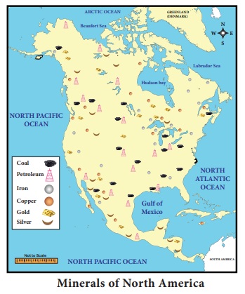
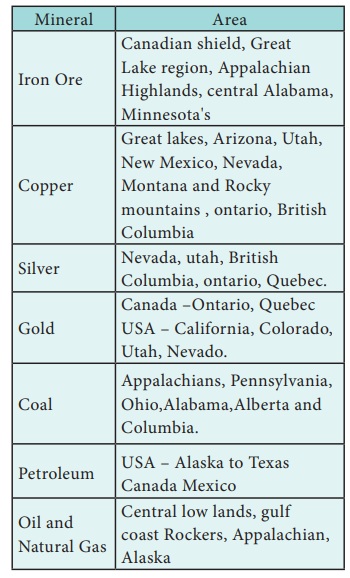
Minerals
North America has rich mineral
resources. North America is the leading producer of Iron Ore, Petroleum,
Natural Gas, Copper, Silver, Sulphur, Zinc, Bauxite and Manganese. Lead and
Uranium are the other important minerals. North America has vast deposit of Oil
and Natural Gas. The United States, Canada and Mexico are among the world top
Oil producers.
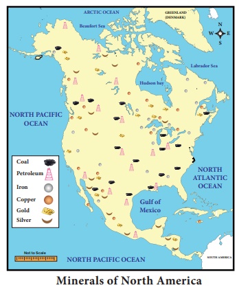
Important Minerals in North America
Industries
North
America has plenty of resources and is needed for industrial development.
Industries are highly concentrated in the north eastern part of the continent
because of large minerals deposits like coal, iron ore etc., and good
transportation network like Roads, Railways and Canals. The United States is
one of the most industrialized countries in the world. Industry contributes
about 25% of Gross National Product. The United State ranks first in Iron and
Steel industry. They use the latest technology in developing their industries.
Major
industries in North America
1. Iron and Steel Industry
The
North American continent is the world's most important Iron and Steel
industrial centre. Iron and Steel industries require Iron Ore, Coal and cheap
transportation. The important centres of the Iron and Steel industries are
Pittsburgh, Chicago and Birmingham in the United States and Hamilton in Canada.
2. Heavy
Engineering Industries
Industries
which require heavy and bulky raw materials using enormous amounts of power,
involvement of huge investment and large transport costs are called heavy
industries. These industries depend heavily on the Iron and Steel industry. The
important Heavy Industries are automobile industries, aircraft industries, ship
building industries, Railway Wagon industries and farm equipment industries.
USA is the largest producer of automobiles. The important Centres of heavy engineering
industries are Detroit, Chicago, Buffalo, Indianapolis, Los Angeles, Saint
Louis, Philadelphia, New York, Baltimore, and Atlanta in USA and Windsor in
Canada.
3. Wood
Pulp and Paper Industry
About
50 per cent of the world’s wood pulp and newsprint is produced by North
America. Canada is the largest producer and exporter of all kinds of paper in
the world. Paper industries are particularly concentrated in Ontario and
Canada.
4. Textiles
Industry
The
textiles industry includes the manufacturing of all textiles like cotton,
woolen, and synthetic. The United States is the largest producer of Cotton
Textiles. The industries are mainly located in Texas. California, Arizona,
Mississippi, Arkansas, and Louisiana. Toronto, Cornwell and Kingston are the
major centres in Canada. Moreover, the cool and wet climate of the area is most
suitable for spinning and weaving, as the yarn does not break frequently. The
Woolen Textile industries are located in the east of the Alleghany Plateau. The
New England region contains 70% woolen textile industries. North America is the
second largest producer of synthetic fibers. Rayon and other synthetic fibers
are made up of cellulose obtained from wood Pulp.
5. The Meat
- Packing Industry
This
is an important industry in Canada and USA where cattle rearing is done on a
large scale in the Prairies. Chicago, Kansas City, Saint Louis in the United
States and Calgary and Winnipeg in Canada are the important meat-packing
centres.
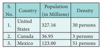
Population
Most
of the people in North America are descendants of settlers from other parts of
the World. The first among them were, the Europeans, arrived in the 16th
century. Today, the
small groups of Native Americans that remain have their own territories and
followed a traditional way of life.
Population
distribution
The current population of North
America as 364,446,736 in the year 2018. North America has about 4.77 % of the
total world's population. The largest country by land area is Canada. The
largest city by population is Mexico City. The population density is about 20
present per Sq. km.
Population
and Density of North America
Densely populated areas: Eastern part of North
America, Great Lakes region, Florida, California, Mexico and Central America
are the mostly densely populated areas.
Moderate populated areas: Central part of United
States, Central Highland, Highlands of Mexico, Central and western Canada are
the Moderate populated areas.
Sparsely populated areas: Northern Canada, Alaska,
Rocky Mountain regions and desert regions are sparsely populated areas.
Languages and Religions most of the people speak
English, Spanish and French. Various faiths have been a major influence of
culture, philosophy and law. Between them 80% of the people follow
Christianity. United States of America is known as “Melting Pot” where hundreds
of different cultures meet, blend and creating a new culture.
Eskimos live in the very cold and inhospitable region where
plenty of fish varieties are available. They were able to dress themselves in
thick warm clothes made of fur, they live in igloos.

Their lives were very simple and they could not alter the
environment to any extent. They specially designed a house by ice and is known
as igloos.
Transport
North America has developed a
well-designed Network of Roadways (Freeways) Railways, Waterways and Airways.
A.
Roadways
North America especially USA and
Canada have the best laid roadways in the world. They are made of Asphalt and
Concrete roads can be used in all weather conditions. The Super Ways (or) Free
ways make travelling easy and fast. The Pan American highway runs from Alaska
in the far North west to Panama in the south.
B.
Railways
North America is extensively served
by an efficient network of railway. Tarns-Continental railways and
Tarns-Canadian railways are link the east and west coast of Canada and United
States. Chicago has the biggest railway junction in the world. The New York
railway junction is one of the busiest railway stations in the world.
C. Waterways
The Great Lakes region along St.
Lawrence and Mississippi rivers are the most important inland waterway in North
America. Quebec City, Montreal, Boston, New York, Philadelphia, Charleston and
New Orleans are some of the important inland ports. New York is the most
important port along the East coast. Vancouver and San Francisco are important
ports on the West Coast of North America.
Panama Canal: In 1914 a Canal was cut across the Isthmus of Panama
for 80 kms long which connects the Atlantic with Pacific Ocean.
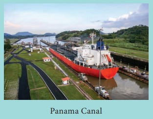
It greatly reduced the
distance between Europe and the West Coast of North and South America.
D.
Airways
Airways provide in valuable means of
transport. All the cities and industrial centres in North America are linked by
airways. New York, Chicago, Los Angeles, Atlanta, Toronto, Montreal and Mexico
City are some of the international airports in North America.
Trade
North America exports a host of
agriculture and industrial products. The main exports are Industrial Machinery,
Automobile, Paper, Fish, Wheat, Bananas, Meat Aircraft, Telecom Equipments,
Chemical, Plastics, Fertilizers, Wood Pulp, Timber, Crude Oil, Natural Gas,
Aluminum, Nickel and Lead. The countries of North America Imports include
Coffee Cocoa Sugar, Textiles, Iron ore and Electronics goods. The countries of
Europe, Japan, China and India are the major trading partners.
Related Topics