Chapter: Civil : Remote Sensing Techniques and GIS : Data Entry, Storage and Analysis
Land Information System
LAND INFORMATION SYSTEM
The land use/land cover system
adopted by almost all concerned organisationsand scientists, engineers and
remote sensing community who are involved in mapping of earth surface features,
is a system derived from the United States Geological Survey (USGS) land
use/land cover classification system. This system was designed on the basis of
the following criteria (Lillesand and Kiefer 1999) : (i) the minimum level of
interpretation accuracy using remotely sensed data should be at least 85
percent, (ii) the accuracy of interpretation for the several categories should
be about equal, (iii) repeatable results should be obtainable from one
interpreter to another and from one time of sensing to another, (iv) the
classification system should be applicable over extensive areas, (v) the
categorization should permit land use to be inferred from the land cover types,
(vi) the classification system should be suitable for u'se with remote sensor
data obtained at different times of the year, (vii) categories should be
divisible into more detailed subcategories that can be obtained from
large-scale imagery or ground surveys, (viii) aggregation of categories must be
possible, (ix) comparison with future land use and land cover data should be
possible, and (x) multiple uses of land should be recognized when possible.
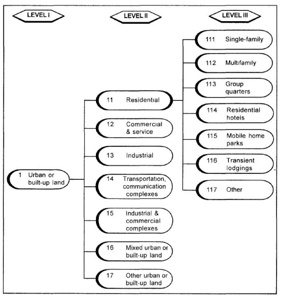
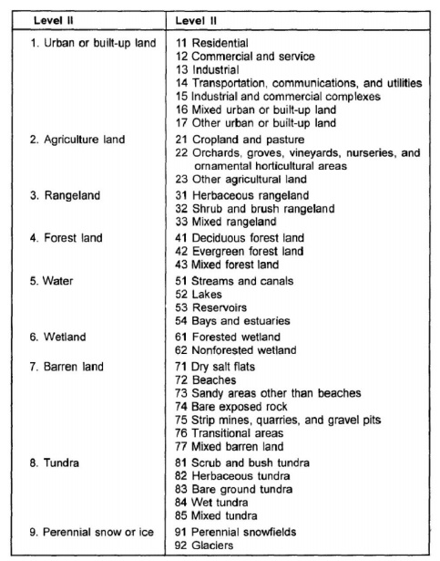
The basic USGS LU/LC
classification system for use with remote sensor data isshown in Table 14.1. On
the basis of this system a multi-level system has been devised because
different degrees of detail can be obtained from aerial and space images, which
depend upon the resolution. Fig. 14.1 illustrates a sample aggregation of
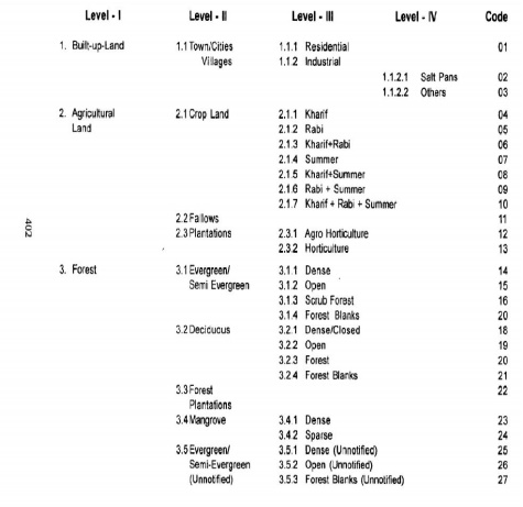
classifications for levels III, II and I. One more level that is level IV is
also devised for local users. In principle, levels IV and III are designed for
local level or very large scale mapping whereas levels II and I are meant for
small scale mapping.
Table 14.2 lists representative interpretation formats for
various land use/land cover classification levels.
USGS Land Use/Land Cover Classification System for
use with Remote Sensor Data
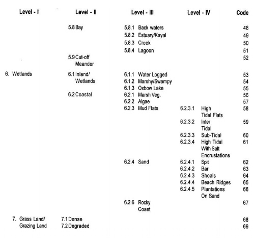
National Remote Sensing Agency (NRSA), Government of India,
has devised ageneralised land uselland cover classification system with respect
to the Indian conditions based on the various categories of Earth surface
features, resolution of available satellite data, capabilities of sensors, and
present and future applications. Table shows the general legend adapted for
land use/land cover categories. This system is used for the development of land
use/land cover map for the project area, namely, MCH area of Hyderabad.
 \
\
Related Topics