Map Reading | Chapter 8 | Geography | 8th Social Science - Components of a map | 8th Social Science : Geography : Chapter 8 : Map Reading
Chapter: 8th Social Science : Geography : Chapter 8 : Map Reading
Components of a map
Components of a map
The basic components of a map are
the
1. Title
2. Scale.
3 Legend or key.
4. Direction
5. Source
6. Map projection and locational
information and
7. Coventional signs and symbols
a. Title
Title tells about the content of the
map and is placed mostly at the top corner or at the bottom corner of the map
b. Scale
The scale is a ratio between the
actual distance on the ground and the distance shown on the map. Generally the
cartographers cannot draw maps the same size as the land. So, they reduce the
size of land or features proportionally. For this purpose maps are drawn to
scale. Each map has its own scale, which is indicated on the map. Often the
scale is shown with a scale bar or a line and number and is placed just below
the title or somewhere at the bottom of the map.
To show large areas like continents
or countries small scale maps are used. Small scale maps can show only major
features omitting the minor ones due to lack of space. For example physical map
of the world will show us only the major physical features in the world. It
represents more area of the earth but gives us less information.
To show a small area like a taluk or
district large scale maps are used.
The large scale maps portray the
information in detail than the small scale maps. For example physical map of
India represents a small area of the earth but gives us more information.
However, there is no criteria for the classification of maps based on scale. It
is only a comparative term.
ACTIVITY : Compare and find out the physical features of
India which are omitted in the physical map of the world
Scales on maps can be represented in three different ways.
They are:
1. Statement
or Verbal scale
2. Representative
Fraction (RF) or Ratio Scale
3. Graphical
or Bar Scale
1. Statement or Verbal scale
In this method, the map scale is
stated in words i.e., 1cm to 1 km. It means 1cm distance on the map corresponds
to 1 km distance on the ground. Thus it is written on the map like 1cm to 1 km,
1 inch to 1 mile etc.
Simple statement scale has the
following characteristics.
a. If the numerator is in
centimeter, the denominator is either in meters or kilometers
b. If the numerator is in inch, the
denominator is in miles
2. Representative Fraction (RF) or Numerical Fraction or Ratio Scale
It shows the relationship between
the map distance and the corresponding ground distance in the same units of
length. R.F. is generally shown as a fraction.
For example, a fraction of 1: 50,000
shows that one unit of length on the map represents 50,000 of the same units on
the ground i.e., 1cm or 1 inch on the map represents 50,000 cm or 50,000 inches
respectively on the ground.
RF is represented as 1/ 50,000 or 1:
50,000
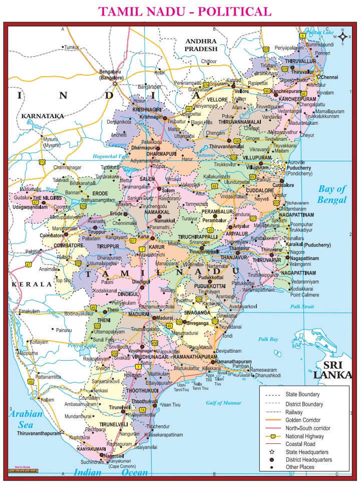
At present there are 37 districts in
Tamil Nadu, including the newly created districts such as Kallakurichi,
Tenkasi, Chengalpet, Ranipet and Tirupathur.
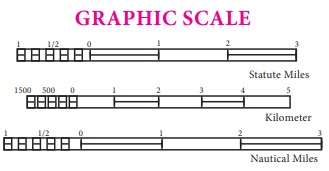
3. Graphical or Bar Scale or Linear Scale
A graphic scale looks like a small
ruler drawn at the bottom of the page. This line is divided and sub divided
into lengths each of which represents a certain distance on the ground. In this
way distances on the ground can directly be measured and read off from the map
by using a piece of string or dividers. This scale has added advantage for
taking copies of maps as the measurement does not change.
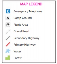
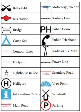
c. Legend or key
A map key or legend is included in a
map to unlock it. It gives you the information needed for the map to make
sense. Maps often use symbols or colours to represent things, and the map key
explains what they mean. Symbols in the key might be pictures or icons that
represent different things on the map.
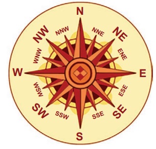
d. Direction
A map must indicate direction. This
is done by means of an arrow pointing to the north. Once the north is located, it
is easy to find the rest of the directions. Directions on a map are often given
with symbol called a compass rose, which always shows north. Sometimes all the
Cardinal directions such as north, south, east and west are shown. In addition
the Intermediate directions of north east, north west, south east and south
west may be given.
e. Source
All maps must show the source of the
data used in the respective maps. The source should normally be given outside
the frame of the map on the bottom right. On the bottom left the name of the
author, publisher, place of publication and year of publication must be given.
f. Map Projection and locational
information
A map projection is a way of
representing the spherical earth on a flat surface of a map. The curved surface
of the earth cannot be shown accurately on a map. So, cartographers use map
projections while mapping the earth surface which would help them to reduce
distortions. Latitudes and longitudes marked on maps give the locational
information of the area covered in the respective maps.
g. Coventional signs and symbols
Conventional signs are symbols used
in maps to represent different features. The symbols are explained in the key
of the map. These symbols give a lot of information in a limited space. With
the use of these symbols, maps can be drawn easily and the concept of the map
can be understood well. There is an International agreement regarding the use
of certain symbols. The symbols fall under this category are Called
Conventional Symbols. Other category is called contextual symbols which are
decided by the cartographers.
Related Topics