Chapter: Civil : Water Resources and Irrigation Engineering : Irrigation Engineering
Canal Irrigation System
Canal
Irrigation System:
General:
A direct irrigation
scheme which makes use of a weir or a barrage, as well as a storage irrigation
scheme which makes use of a storage dam or a storage reservoir, necessitates
the construction of a network of canals, as explained earlier. The entire
system of main canals, branch canals, distributaries and minors is to be
designed properly for a certain realistic value of peak discharge that must
pass through them, so as to provide sufficient irrigation to the commanded
areas. These canals have to be aligned and excavated either in alluvial soils
or non ŌĆ'alluvial soils; depending upon which they are called alluvial canals or
non ŌĆ'alluvial canals, as the case may be.
Alluvial and Non ŌĆ'alluvial Canals:
Alluvial soils:
The soil which is
formed by the agency of water, over a course of time, is called alluvial soil.
A river before joining the sea, gets divided into a number of streams forming
what is called as the River Delta. In the deltaic region, a river carries heavy
charge of silt, which gets deposited on the adjoining lands, as and when the
river overflows its banks during flood season. The process of silt deposition
continues over long periods of time, resulting in the formation of a soil
called Alluvial Soil. Hence the soil which is formed by continuous silt
deposition is called alluvial soil. The area of alluvial soil is even and is
having a flat surface slope. Hard foundations, are generally not available in
this kind of soil. In prehistoric periods, the entire Indo ŌĆ'Gengetic Plain was
perhaps a depression, and was filled up with constant silt deposition,
resulting in the formation of an alluvial ŌĆ'soil region. The rivers flowing
through such alluvial areas, have a tendency to shift their courses. The river
bed consists of sand of considerable thickness, and is, therefore, permeable.
Whenever, an irrigation structure is to be constructed on such a river, special
precautions and design methods are to be adopted. Most of our North Indian
rivers, which pass through alluvial soils, do pose these problems. The canals
when excavated through such soils, are called Alluvial Canals. Canal irrigation
(Direct irrigation using a weir or a barrage) is generally preferred in such
areas as compared to storage irrigation (i.e. by using a dam). Alluvial soil is
very fertile as it can absorb a fair percentage of rainfall and retain it in
the substratum, making it highly productive.
Non ŌĆ'alluvial Soils:
Mountaineous regions
may go on disintegrating over a period of time, resulting in the formation of a
rocky plain area, called non ŌĆ'alluvial area. It has an uneven topography, and
hard foundations are generally available. The rivers, passing through such
areas, have no tendency to shift their courses, and they do not pose much
problems for designing irrigation structures on them. Canals, passing through
such areas are called Non ŌĆ'alluvial Canals. Major portion of Maharashtra State
is non ŌĆ'alluvial. Storage irrigation is preferred to canal irrigation in this
type of soil. Non ŌĆ'alluvial soils may be permeable or impermeable, but
generally, they are non ŌĆ' permeable.
Alignment
of Canals
Irrigation canals can be aligned in any of the three
ways:
1. As
watershed canal
2. As
contour canal; and
3. As
side ŌĆ'slope canal
Watershed Canal. The dividing line between the catchment area of two drains (streams) is called the watershed. Thus, between two major stream, there is the main watershed which divides the drainage areas of the two. Similarly, between any tributary and the main stream, and also between any two tributaries there, are subsidiary watersheds, dividing the drainage between the two streams on either side.
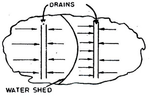
Figure: Alignment of a Water ŌĆ'shed canal
along the water ŌĆ'shed
For canal system in
plain areas, it is often necessary as well as advantageous to align all
channels on the watersheds of the areas, they are designed to irrigate. The
canal, which is aligned along any natural watershed, is called a watershed
canal. From such a canal irrigation, water is taken out by gravity on either
side of the canal, directly or through small irrigation channels.
Moreover,
cross ŌĆ'drainage works are avoided, as the natural drainage will never cross a
watershed, because all the drainage flows away from the watershed. Sometimes,
watershed may have to be abandoned in order to bypass localities settled on the
watershed.
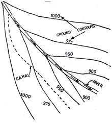
Figure:
Alignment of a Contour canal
(ii) Contour Canal: The
above arrangement of providing the canals along the watershed is not possible
in hill areas. In the hills, the river flows in the valley, while the watershed
or the ridge line may be hundred of metres above it. It becomes uneconomical to
take the canal on top of such a ridge. The channel, in such cases, is generate
sufficient flow velocities, are given to it.
The maximum designed
slope that can be provided in the canal without generating excessive
velocities, is generally less than the available country slope. The difference
is accommodated by providing canal falls at suitable places. A contour channel
irrigates only on one side, because the areas on the other side are higher.
As
the drainage flow is always at right angles to the ground contours, such a
channel would definitely have to cross drainage lines. Suitable cross drainage
works are then provided.
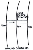
Figure:
Alignment of a Side Slope canal
(iii)
Side Slope Canal: A side slope channel is that which is
aligned at right angles to the contours, i.e. along the side slopes, as
shown in figure.
Such a channel is
parallel to the natural drainage flow and hence, does not intercept cross
drainage, and hence no cross drainage works are required.
Distribution System for Canal
Irrigation:
It has been emphasized
earlier that the direct irrigation scheme using a weir or a barrage, as well as
the storage irrigation scheme using a dam or a reservoir, require a network of
irrigation channels. The entire network of irrigation channels is called canal
system. The canal system, as explained earlier in chapter, consists of:
1. Main
canal
2. Branch
canals
3. Distributaries
4. Minors,
and
5. Watercourses
In case of direct
irrigation scheme, a weir or a barrage is constructed across the river, and
water is headed up on the upstream side. The arrangement is known as Head Works
or Diversion Head Works, and will be explained in details, a litter later, in
chapter. Water is diverted into the main canal by means of a diversion weir. A
head regulator is provided at the head of the main canal, so as to regulate the
flow of water into the main canal.
In storage irrigation
scheme, a dam is constructed across the river, thus forming a reservoir on the
upstream side of the river. The water from this reservoir is taken into the
main canal through the outlet sluices. There are generally two main canals,
which off ŌĆ'take from the reservoir, called the Left Bank Canal and the Right
Bank Canal, as shown in figure.
In certain storage irrigation schemes, commanded irrigation area may be far away from the dam site. In such cases, a separate head works consisting of a pick ŌĆ'up weir, is constructed across the river on the downstream side of the main dam, at a point where the commanded area begins. The main canal, in such a case, will off ŌĆ'take from the upstream side of the weir, just as in a normal diversion weir scheme. This arrangement is shown in figure.
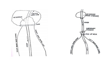
Figure: Storage Irrigation Scheme Figure: Storage Irrigation Scheme with
Pick up weir
In both these
irrigation scheme, when once the water reaches into the main canal, the problem
left is to distribute this water into the fields. The purpose is achieved
through a network of channels, as described below:
(a)
Main Canal (Head reach): The canal head
works are generally situated in a valley, and the canal should mount the
watershed in the shortest possible distance. The canal, in this reach, must be
aligned very carefully and has to be generally excavated in deep cuttings below
N.S.L. (natural surface level). Sometimes, it has to cross various drainage
lines. Many a times, straight alignment has to be sacrificed in order to
achieve a good site for cross drainage works.
(b)
Main Canal (Portion below head reach):
Attempts are made to align the canal along the watershed and somewhat central
to the commanded area. Sometimes, water ŌĆ'shed has to be sacrificed to bypass
towns and villages, etc. Main canal is not required to do any irrigation.
(ii)
Branch Canals: When a main canal leaves
the high ground and must, therefore, bifurcate into branches, covering the
whole tract required to be irrigated, the canals in such portions are called
Branch Canals. Very little irrigation is done from the branch canals. Attempts
are made to align them along subsidiary water ŌĆ'sheds. Discharge in a branch
channel, is generally, more than 30 cumecs.
(iii)
Distributaries: Smaller channels which
take off from the branch canals and distribute their supply through outlets
into minors or water courses, are called distributaries. They are aligned
either as watershed channels or as side slope channels. Discharge in a
distributaries is generally less than 30 cumecs. Minors: Sometimes, the country
is such that the distance between the distributary outlet and the farmerŌĆÖs
field is very long; say more called minors, are taken off from the
distributaries, so as to supply water to the cultivators at the
point nearer to their fields. Discharge in a minor,
is generally, less than 2.5 cumecs.
(v) Watercourses: These are not the government
channels and belong to the cultivators. These are small channels, which are
excavated by cultivators, to take water from the government ŌĆ' owned outlet
point provided in the distributary or the minor.
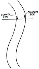
Curves in channels:
Attempts
are made to align the channels straight as far as possible. But many a times,
the curves become inescapable. Whenever, a curve is proposed, while aligning
unlined channels, it should be as gentle as possible. A curve causes
disturbance of flow and results in silting on the inside (i.e. convex side) and
scouring on the outside (i.e. concave side).
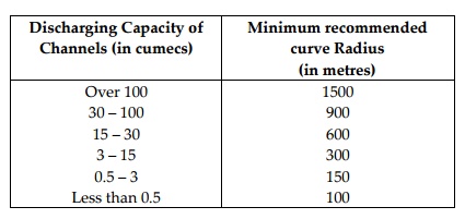
Pitching is, therefore,
sometimes proposed on the concave side, so as to avoid scouring. If the
discharge is more, the curve should be more gentle and should, therefore, have
more radius. The generally adopted minimum values or radii for different discharges
are tabulated below in table.
Table
Discharging
Capacity of Minimum
recommended
Channels (in
cumecs) curve Radius(in
metres)
Over 100 1500
30 ŌĆ'100 900
15 ŌĆ'30 600
3 ŌĆ'15 300
0.5 ŌĆ'3 150
Less than 0.5 100
Certain Important Definitions:
Before we discuss the
techniques, which are employed to determine the ŌĆśdes for a channel, let us
first of all, define certain important terms, with which we come across in the
design of any irrigation canal system.
Gross Commanded Area
(G.C.A): It is the total area, bounded within the irrigation
boundary of a project, which can be economically irrigated without
considering the limitation of the quantity of available water. It includes the
cultivable as well as the non ŌĆ'cultivable area.
Related Topics