Population, Transport, Communication & Trade in India | Geography | Social Science - Answer the following in a paragraph | 10th Social Science : Geography : Chapter 6 : India - Population, Transport, Communication & Trade
Chapter: 10th Social Science : Geography : Chapter 6 : India - Population, Transport, Communication & Trade
Answer the following in a paragraph
V. Answer the following in a paragraph
1. What
is urbanization? Explain its problem.
Urbanization: The process of society's transformation from Rural to urban is known as Urbanization.
Major problems of
urbanization:
• It creates urban sprawl.
• It makes overcrowding in urban centres
• It leads to shortage of houses in urban areas.
• It leads to the formation of slums.
• It increases traffic congestion in cities.
• It creates water scarcity in cities.
• It creates drainage problem.
• It poses the problem of solid waste management.
• It increases the rate of crime.
2. Explain
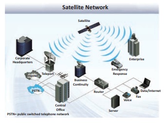
the importances of satellite communication in India.
• The use of Satellite in getting a continuous and synoptic view
of larger area has made this communication system very vital for the country.
• Satellite images are used for weather forecasting, monitoring
of natural calamities, surveilance of border areas.
• The communication through satellites emerged as a new era in communication in our country
after the establishment of ISRO in 1969.
Satellite system in
India:
• Satellite system in India is grouped into two as
- The Indian National Satellite System (INSAT)
- The Indian Remote Sensing Satellite System (IRS).
• The INSAT (1983) is a multi-purpose system for
telecommunication, meteorological observation and for various programs.
• The INSAT series are used for relaying signals to television,
telephone, radio, mobile phone. It is also useful in weather detection,
internet and military applications.
• The INSAT series, GSAT series, KALPANA-1, HAMSAT, EDUSAT and
GSAT-7A are the major communication satellites used for communication purpose.
- INSAT-1B (30 August 1983) is the first communication satellite
in INSAT series.

3. Classify
and explain the roadways in India.
Roads play an important role in carrying goods and passengers
for short, medium and long distances. Roads are the most universal mode of
transport,
Classification of
Roadways in India:
National Highways
(NH):
• NH form the most important system of road transportation. They
are running through length and breadth of the country connecting capitals of
states, major ports, rail junctions, industrial and tourist centres.
• Ministry of Road Transport and Highways of India is
responsible for the development and maintenance of National Highways in India.
Total length of
NHs:
The longest National Highway is NH-7 (Varanasi - Uttar Pradesh
to Kanniyakumari - Tamilnadu) 2369 km.
• The shortest National
Highway is NH-47A (Ernakulum to Kochi port - Willington Island) 6 km.
State Highways:
• The State highways are usually roads that link important
cities, towns and district headquarters within the state. They connect them
with national highways or highways of neighbouring states.
• The roads are administered and financed by state governments.
District Roads:
• The roads provide connectivity between the district and taluk
headquarters with the state highways and national highways.
• District roads are constructed and maintained by the Public
Works Department of the states.
Rural Roads
(Village Roads):
• These roads are vital for providing links in the rural areas.
The village road links the different villages with their neighbouring towns.
• These roads are maintained by Village Panchayats.
Border Roads:
• These roads are constructed and maintained by Border Roads
Organization. It was established in 1960 for the development of the roads of
strategic importance in the Northern and North eastern border areas.
• There are also Golden Quadrilateral and North-South and
East-West corridors.
Express ways:
• These are multi-lane good quality highways for high speed
traffic.
• The important express ways are
• Mumbai - Pune Road.
• Kolkata - Dumdum Airport road
• Durgapur - Kolkata road
• Yamuna express way between Delhi and Agra.
International
Highways:
• The roads that link India with neighbouring countries for
harmonious relationship with them.
• These highways have been constructed with an aid from World
Bank.
• These roads connect important highways in India with those of
Pakistan, Nepal, Bhutan, Bangladesh and Myanmar.
Related Topics