Chapter: Civil Surveying : Fundamentals and Chain Surveying
Types of Surveying
TYPES
OF SURVEYING
OPERATIONS
The practice of surveying actually boils
down to fieldwork and office work. The FIELDWORK consists of taking
measurements, collecting engineering data, and testing materials. The OFFICE
WORK includes taking care of the computation and drawing the necessary
information for the purpose of the survey.
FIELDWORK
FIELDWORK is of primary importance in
all types of surveys. To be a skilled surveyor, you must spend a certain amount
of time in the field to acquire needed experience. The study of this training
manual will enable you to understand the underlying theory of surveying, the
instruments and their uses, and the surveying methods. However, a high degree
of proficiency in actual surveying, as in other professions, depends largely
upon the duration, extent, and variation of your actual experience.
You should develop the habit of STUDYING
the problem thoroughly before going into the field, You should know exactly
what is to be done; how you will do it; why you prefer a certain approach over
other possible solutions; and what instruments and materials you will need to
accomplish the project.
It is essential that you develop SPEED
and CONSISTENT ACCURACY in all your fieldwork. This means that you will need practice
in handling the instruments, taking observations and keeping field notes, and
planning systematic moves.
It is important that you also develop
the habit of CORRECTNESS. You should not accept any measurement as correct
without verification. Verification, as much as possible, should be different
from the original method used in measurement. The precision of measurement must
be consistent with the accepted standard for a particular purpose of the
survey.
Fieldwork also includes adjusting the
instruments and caring for field equipment. Do not attempt to adjust any
instrument unless you understand the workings or functions of its parts.
Adjustment of instruments in the early stages of your career requires close
supervision from a senior EA.
Factors
Affecting Fieldwork
The surveyor must constantly be alert to
the different conditions encountered in the field. Physical factors, such as
TERRAIN AND WEATHER CONDITIONS, affect each field survey in varying degrees.
Measurements using telescopes can be stopped by fog or mist. Swamps and flood
plains under high water can impede taping surveys. Sights over open water or
fields of flat, unbroken terrain create ambiguities in measurements using
microwave equipment. The lengths of light-wave distance in measurements are
reduced in bright sunlight. Generally, reconnaissance will predetermine the
conditions and alert the survey party to the best method to use and the rate of
progress to expect.
The STATE OF PERSONNEL TECHNICAL
READINESS is another factor affecting field-work. As you gain experience in
handling various surveying instruments, you can shorten survey time and avoid
errors that would require resurvey.
The PURPOSE AND TYPE OF SURVEY are
primary factors in determining the accuracy requirements. First-order
triangulation, which becomes the basis or "control" of future
surveys, is made to high-accuracy standards. At the other extreme, cuts and fills
for a highway survey carry accuracy standards of a much lower degree. In some
construction surveys, normally inaccessible distances must be computed. The
distance is computed by means of trigonometry, using the angles and the one
distance that can be measured. The measurements must be made to a high degree
of precision to maintain accuracy in the computed distance.
So, then, the purpose of the survey
determines the accuracy requirements. The required accuracy, in turn,
influences the selection of instruments and procedures. For instance,
comparatively rough procedures can be used in measuring for earthmoving, but
grade and alignment of a highway have to be much more precise, and they,
therefore, require more accurate measurements. Each increase in precision also
increases the time required to make the measurement, since greater care and
more observations will be taken. Each survey measurement will be in error to
the extent that no measurement is ever exact. The errors are classified as
systematic and accidental and are explained in the latter part of this text.
Besides errors, survey measurements are subject to mistakes or blunders. These
arise from misunderstanding of the problem, poor judgment, confusion on the
part of the surveyor, or simply from an oversight. By working out a systematic
procedure, the surveyor will often detect a mistake when some operation seems
out of place. The procedure will be an advantage in setting up the equipment,
in making observations, in recording field notes, and in making computations.
Survey speed is not the result of
hurrying; it is the result of saving time through the following factors:
1.
The skill of the surveyor in handling
the instruments
2.
The intelligent planning and preparation
of the work
3.
The process of making only those
measurements that are consistent with the accuracy requirements
Experience is of great value, but in the
final analysis, it is the exercise of a good, mature, and competent degree of
common sense that makes the difference between a good surveyor and an
exceptional surveyor.
Field
Survey Parties
The size of a field survey party depends
upon the survey requirements, the equipment available, the method of survey,
and the number of personnel needed for performing the different functions. Four
typical field survey parties commonly used in the SEABEEs are briefly described
in this section: a level party, a transit party, a stadia party, and a plane
table party.
LEVEL PARTY.- The
smallest leveling party consists of two persons: an instrumentman and a
rodman. This type of organization requires the instrumentman to act as note
keeper. The party may need another recorder and one or more extra rodmen to
improve the efficiency of the different leveling operations. The addition of
the rodmen eliminates the waiting periods while one person moves from point to
point, and the addition of a recorder allows the instrumentman to take readings
as soon as the rodmen are in position. When leveling operations are run along
with other control surveys, the leveling party may be organized as part of a
combined party with personnel assuming dual duties, as required by the work
load and as designated by the party chief.
TRANSIT PARTY.- A
transit party consists of at least three people: an instrumentman, a head
chainman, and a party chief. The party chief is usually the note keeper and may
double as rear chainman, or there may be an additional rear chainman. The
instrumentman operates the transit; the head chainman measures the hori-zontal
distances; and the party chief directs the survey and keeps the notes.
STADIA PARTY.- A
stadia party should consist of three people: an instrumentman, a note keeper,
and a rodman. However, two rodmen should be used if there are long distances
between observed points so that one can proceed to a new point, while the other
is holding the rod on a point being observed. The note keeper records the data
called off by the instrumentman and makes the sketches required.
PLANE TABLE PARTY.- The
plane table party consists of three people: a topographer or plane table
operator, a rodman, and a computer. The topographer is the chief of the party
who sets up, levels, and orients the plane table; makes the necessary readings
for the determination of horizontal distances and elevations; plots the details
on the plane table sheet as the work proceeds; and directs the other members of
the party.
The rodman carries a stadia rod and
holds it vertically at detail points and at critical terrain points in the
plotting of the map. An inexperienced rodman must be directed by the
topographer to each point at which the rod is to be held. An experienced rodman
will expedite the work of the party by selecting the proper rod positions and
by returning at times to the plane table to draw in special details that he may
have noticed.
The computer reduces stadia readings to
horizontal and vertical distances and computes the ground elevation for rod
observations. He carries and positions the umbrella to shade the plane table
and performs other duties as directed by the topographer. At times, the
computer may be used as a second rodman, especially when the terrain is
relatively flat and computations are mostly for leveling alone.
Field
Notes
Field notes are the only record that is
left after the field survey party departs the survey site. If these notes are
not clear and complete, the field survey was of little value. It is therefore
necessary that your field notes contain a complete record of all of the
measurements made during the survey and that they include, where necessary,
sketches and narrations to clarify the notes. The following guidelines apply.
LETTERING.- All
field notes should be lettered legibly. The lettering should be in freehand,
vertical or slanted Gothic style, as illustrated in basic drafting. A fairly
hard pencil or a mechanical lead holder with a 3H or 4H lead is recommended.
Numerals and decimal points should be legible and should permit only one
interpretation.
FORMAT.- Notes
must be kept in the regular field notebook and not on scraps of paper for later
transcription. Separate surveys should be recorded on separate pages or in
different books. The front cover of the field notebook should be marked with
the name of the project, its general location, the types of measurements
recorded, the designation of the survey unit, and other pertinent information.
The inside front cover should contain
instructions for the return of the notebook, if lost. The right-hand pages
should be reserved as an index of the field notes, a list of party personnel
and their duties, a list of the instruments used, dates and reasons for any
instrument changes during the course of the survey, and a sketch and
description of the project.
Throughout the remainder of the
notebook, the beginning and ending of each day'swork should be clearly
indicated. Where pertinent, the weather, including temperature and wind
velocities, should also be recorded. To minimize recording errors, someone
other than the recorder should check and initial all data entered in the
notebook.
RECORDING.- Field
note recording takes three general forms: tabulation, sketches, and descriptions.
Two, or even all three, forms may be combined, when necessary, to make a
complete record.
In TABULATION, the numerical
measurements are recorded in columns according to a prescribed plan. Spaces are
also reserved to permit necessary computations.
SKETCHES add much to clarify field notes
and should be used liberally when applicable. They may be drawn to an
approximate scale, or important details may be exaggerated for clarity. A small
ruler or triangle is an aid in making sketches. Measurements should be added
directly on the sketch or keyed in some way to the tabular data. An important
requirement of a sketch is legibility. See that the sketch is drawn clearly and
large enough to be understandable.
Tabulation, with or without added
sketches, can also be supplemented with DESCRIPTIONS. The description may be
only one or two words to clarify t he recorded measurements. It may also be
quite a narration if it is to be used at some future time, possibly years
later, to locate a survey monument.
ERASURES ARE NOT PERMITTED IN FIELD
NOTEBOOKS. Individual numbers or lines recorded incorrectly are to be lined out
and the correct values inserted. Pages that are to be rejected are crossed out
neatly and referenced to the substituted pages. THIS PROCEDURE IS MANDATORY
since the field notebook is the book of record and is often used as legal
evidence. Standard abbreviations, signs, and symbols are used in field notebooks.
If there is any doubt as to their meaning, an explanation must be given in the
form of notes or legends.
1.5.OFFICE
WORK
OFFICE WORK in surveying consists of
converting the field measurements into a usable format. The conversion of
computed, often mathematical, values may be required immediately to continue
the work, or it may be delayed until a series of field measurements is
completed. Although these operations are performed in the field during lapses
between measurements, they can also be considered office work. Such operations
are normally done to save time. Special equipment, such as calculators,
conversion tables, and some drafting equipment, are used in most office work.
In office work, converting field
measurements (also called reducing) involves the process of computing,
adjusting, and applying a standard rule to numerical values.
Computation
In any field survey operation,
measurements are derived by the application of some form of mathematical
computation. It may be simple addition of several full lengths and a partial
tape length to record a total linear distance between two points. It maybe the
addition or subtraction of differences in elevation to determine the height of
instrument or the elevation during leveling. Then again, it maybe checking of
angles to ensure that the allowable error is not exceeded.
Office computing converts these
distances, elevations, and angles into a more usable form. The finished
measurements may end up as a computed volume of dirt to be moved for a highway
cut or fill, an area of land needed for a SEABEE construction project, or a new
position of a point from which other measurements can be made.
In general, office computing reduces the
field notes to either a tabular or graphic form for a permanent record or for
continuation of fieldwork.
Adjustment
Some survey processes are not complete
until measurements are within usable limits or until corrections have been
applied to these measurements to distribute accumulated errors. Small errors
that are not apparent in individual measurements can accumulate to a sizeable
amount. Adjusting is the process used to distribute these errors among the many
points or stations until the effect on each point has been reduced to the
degree that all measurements are within usable limits.
For example, assume that 100
measurements were made to the nearest unit for the accuracy required. This
requires estimating the nearest one-half unit during measurement. At the end of
the course, an error of + 4 units results. Adjusting this means each
measurement is reduced 0.04 unit. Since the measurements were read only to the
nearest unit, this adjustment would not be measurable at any point, and the
adjusted result would be correct.
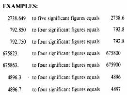
SIGNIFICANT
FIGURES.- The term known to be exact.
In a measured quantity, the number of
significant figures is determined by the accuracy of the measurement. For
example, a roughly measured distance of 193 ft has three significant figures.
More carefully measured, the same distance, 192.7 ft, has four significant
figures. If measured still more accurately, 192.68 ft has five significant
figures.
In surveying, the significant figures
should reflect the allowable error or tolerance in the measurements. For
example, suppose a measurement of 941.26 units is made with a probable error of
� 0.03 unit. The � 0.03 casts some doubt on the fifth digit which can vary from
3 to 9, but the fourth digit will still remain 2. We can say that 941.26 has
five significant figures; and from the allowable error, we know the fifth digit
is doubtful. However, if the probable error were �0.07, the fourth digit could
be affected. The number could vary from 941.19 to 941.33, and the fourth digit
could be read 1, 2, or 3. The fifth digit in this measurement is meaningless.
The number has only four significant figures and should be written as such.
The number of significant figures in a
number ending in one or more zeros is unknown unless more information is given.
The zeros may have been added to show the location of the decimal point; for
example, 73200 may have three, four, or five significant figures, depending on
whether the true value is accurate to 100, 10, or 1 unit(s). If the number is
written 73200.0, it indicates accuracy is carried to the tenth of a unit and is
considered to have six significant figures.
When decimals are used, the number of
significant figures is not always the number of digits. A zero may or may not
be significant, depending on its position with respect to the decimal and the
digits. As mentioned above, zeros may have been added to show the position of
the decimal point. Study the following examples:
0.000047
. . . . . . .two significant figures
0.0100470
. . . . . . .six significant figures
0.1000470
. . . . . . .seven significant figures
2.0100470
. . . . . . .eight significant figures
In long computations, the values are
carried out to one more digit than required in the result. The number is
rounded off to the required numbers of digits as a final step.
ROUNDING OFF NUMBERS.- Rounding
off is the process of dropping one or more digits and replacing them
with zeros, if necessary, to indicate the number of significant figures.
Numbers used in surveying are rounded off according to the following rules:
1.
When the digit to be dropped is less
than 5, the number is written without the digit or any others that follow it.
(Example: 0.054 becomes 0.05.)
2.
When the digit is equal to 5, the
nearest EVEN number is substituted for the preceding digit. (Examples: 0.055
becomes 0.06; 0.045 becomes 0.04.)
3.
When the digit to be dropped is greater
than 5, the preceding digit is increased by one. (Example: 0.047 becomes 0.05.)
4.
Dropped digits to the left of the
decimal point are replaced by zeros.
5. Dropped digits to the right of the decimal points are never replaced.
CHECKING COMPUTATIONS.- Most
mathematical problems can be solved by more than one method. To check a
set of computations, you should use a method that differs from the original
method, if possible. An inverse solution, starting with the computed value and
solving for the field data, is one possibility. The planimeter and the
protractor are also used for approximate checking. A graphical solution can be
used, when feasible, especially if it takes less time than a mathematical or
logarithmic solution. Each step that cannot be checked by any other method must
be recomputed; and, if possible, another EA should recompute the problem. When
an error or mistake is found, the computation should be rechecked before the
correction is accepted
Drafting
Used In Surveying
The general concept of drafting and the
use of drafting instruments were discussed in chapters 2 through 5. By this
time, you should be familiar with the use of various drafting instruments and
with the elements of mechanical drawing. Draft-ing used in surveying, except
for some freehand sketches, is generally performed by mechanical means; for
example, the drawing of lines and surveying symbols is generally done with the
aid of a straightedge, spline, template, and so on.
The drawings you make that are directly
related to surveying will consist of maps, profiles, cross sections, mass
diagrams, and, to some extent, other graphical calculations. Their usefulness
depends upon how accurately you plot the points and lines representing the
field measurements. It is important that you adhere to the requirements of
standard drawing practices. Correctness, neatness, legibility, and well
proportioned drawing arrangements are signs of professionalism.
In drawing a PROPERTY map, for example,
the following general information must be included:
1.
The length of each line, either
indicated on the line itself or in a tabulated form, with the distances keyed
to the line designation.
2.
The bearing of each line or the angles
between lines.
3.
The location of the mapped area as
referenced to an established coordinate system.
4.
The location and kind of each
established monument indicating distances from referencemarks.
5.
The name of each road, stream, landmark,
and so on.
6.
The names of all property owners,
including those whose lots are adjacent to the mapped area.
7.
The direction of the true or magnetic
meridian, or both.
8.
A graphical scale showing the
corresponding numerical equivalent.
9.
A legend to the symbols shown on the
map, if those shown are not standard signs.
10.
A title block that distinctly identifies
the tract mapped or the owner'snam.(It is required to contain the name of the
surveyor, the name of the draftsman, and the date of the survey.)
Besides the above information, there are
some other items that may be required if the map is to become a public record.
When this is the case, consult the local office of the Bureau of Land
Management or the local surveyors'societyfor the correct general information
requirements to be included in the map to be drawn.
In drawing maps that will be used as a
basis for studies, such as those to be used in roads, structures, or waterfront
construction, you are required to include the following general information:
1.
Information that will graphically
represent the features in the plan, such as streams, lakes, boundaries, roads,
fences, and condition and culture of the land.
2.
The relief or contour of the land.
3.
The graphical scale.
4.
The direction of the meridian.
5.
The legend to symbols used, if they are
not conventional signs.
6.
A standard title block with a neat and
appropriate title that states the kind or purpose of the map. Again, the
surveyor'snameandthat of the draftsman, as well as the date of survey, are to
be included in the title block.
Maps developed as a basis for studies
are so varied in purpose that the above information may be adequate for some
but inadequate for others. The Engineering Aid, when in doubt, should consult
the senior EA, the engineering officer, or the operations officer as to the
information desired in the proposed map. The senior EA or the chief of the
field survey party is required to know all these requirements before actual
fieldwork is started.
A map with too much information is as
bad as a map with too little information on it. It is not surprising to find a map
that is so crowded with information and other details that it is hard to
comprehend. If this happens, draw the map to a larger scale or reduce the
information or details on it. Then, provide separate notes or descriptions for
other information that will not fit well and thus will cause the appearance of
overcrowding. Studying the features and quality of existing maps developed by
NAVFACENGCOM and civilian architects and engineers (A & E) agencies will
aid you a great deal in your own map drawing.
Related Topics