Chapter: Civil : Remote Sensing Techniques and GIS : Data Entry, Storage and Analysis
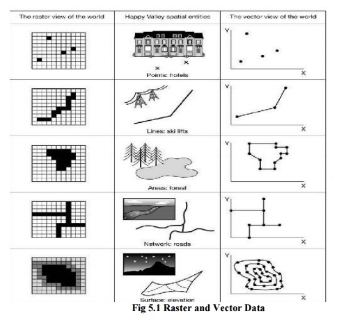
Data Models Vector and Raster Data
DATA MODELS VECTOR AND RASTER DATA
A vector based GIS is defined by the vectorial representation
of its geographic data. The most common representation of map is using vector
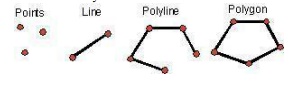
date that is consist of point, line and polygon
1.. VECTOR DATA
i.
Point Data -- layers described by points (or
"event") described by x,y (lat,long; east, north)
ii.
Line/Polyline Data -- layers that are described by
x,y points (nodes, events) and lines (arcs) between points (line segments and
polylines)
iii.
Polygon Data -- layers of closed line segments
enclosing areas that are described by attributes
Polygon data
can be "multipart" like
the islands of
the state of
Hawaii.
Vector Data Structures
� Fundamental unit is the x, y coordinate (vertex)
- points
are explicitly defined
- lines,
arcs and polygons are constructed
� Map area is presumed continuous
- position
can be defined with great precision; limited by precision of software/hardware
and
source
data
� Usually provides finer spatial resolution
than raster model
Point
A zero-dimensional abstraction of
an object represented by a single X,Y co-ordinate. A point normally represents
a geographic feature too small to be displayed as a line or area; for example, the location of a building location
on a small-scale map, or the location of a service cover on a medium scale map.
Line
A set of ordered co-ordinates
that represent the shape of geographic features too narrow to be displayed as
an area at the given scale (contours, street centrelines, or streams), or
linear features with no area (county boundary lines). A lines is synonymous
with an arc.
Polygon
A feature used to represent
areas. A polygon is defined by the lines that make up its boundary and a point
inside its boundary for identification.Polygons have attributes that describe
the geographic featurethey represent.
2.. RASTER DATA
Consists of a matrix of cells (or pixels)
organized into rows and columns (or a grid) where each cell contains a value
representing information, such as temperature. Rasters are digital aerial
photographs, imagery from satellites, digital pictures, or even scanned maps.
Related Topics