Geography - Weather Map Interpretation | 11th Geography : Chapter 12 : Weather Maps
Chapter: 11th Geography : Chapter 12 : Weather Maps
Weather Map Interpretation
Weather
Map Interpretation
The weather map is a symbolic
representation of the atmospheric conditions of an area at a given time. On a
weather map, you will find isobars and symbols related to pressure, direction
and velocity of winds, clouds, precipitation and sea condition on a base map
with political boundaries. These details are recorded at different weather
stations at specified time.
Meteorological Departments forecast
weather conditions by evaluating these weather elements shown on a weather map.
This weather map is used in predicting weather conditions for a day, a week or
a month in advance, which helps in taking precautions and safety measures.
Weather forecasts help farmers, fishermen and crew of ships. It also helps air
flights in predicting atmospheric condition a few hours ahead.
Weather maps are the collection of
weather information from various meteorological stations pertaining to the
The weather
charts are prepared daily based on weather observations collected by the Indian
Meteorological Department (IMD). The basic knowledge of weather elements is
needed to interpret the weather maps. The essential weather elements to
interpret the given weather maps are:
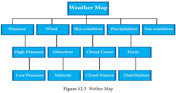
Schematic representation of weather
map elements
Weather Map Interpretation
The Indian daily weather map is a
political map of India, which also includes Pakistan, Afghanistan, part of
China, Nepal, Bhutan, Myanmar and Sri Lanka with weather symbols indicating
recorded weather data, isobars and keys for symbols.
Weather Map Interpretation – Monsoon Season (Example 1)
Weather map interpretation includes
study and interpretation of all the weather parameters. The given weather map
depicts the observed weather conditions on Monday 1st June 1992 at 08.30 Hrs I.S.T (0300 HRS GMT).
Generally in India this observation is predicted as the southwest monsoon
season that gives rain.
The key elements for weather map
interpretation are:
Range
of Isobars: From the given weather map it is observed that the
isobars range from 1002 mb to 1010mb. The lowest value of 1002 mb is found over
Bihar and West Bengal as an enclosed isobar. The 1010 mb is the highest value
and is observed in the extreme south western part of the Arabian Sea.
Location
of Low Pressure: In this weather map, four low pressure zones are identified. Low pressure
prevails in Bihar and West Bengal, North Western Pakistan, Assam, Eastern part
of India and Lakshadweep Island.
Location
of High Pressure: The high pressure prevails over Afghanistan with 1008mb and the other high
pressure prevails over the south western part of the Arabian Sea with 1010 mb.
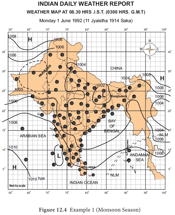
Gradient
of Pressure: On this map, the pressure gradient is steep along
the western coast of India.
Wind
Direction: The wind moves from west to east in the extreme
southern part of India, The wind flows from North West to the south east in the
rest of the Plateau region. The wind velocity ranges from 5 – 15 knots in most
of the places on the given day.
The wind is not strong in North but comparatively
strong in south.
Cloud
Cover: Clear sky is noticed in the North and north western part of
India. Eastern coastal states are partly clouded and the southern states show
extreme cloudiness and or overcast.
Sea
Condition: Northern Limit of Monsoon prevails over the Andaman Sea.
Precipitation:
The rainfall occurred in Assam and Meghalaya because low
pressure prevails in near Assam, southern parts of Karnataka, Kerala and
Lakshadweep.
Departure of Maximum and Minimum temprature from Normal
Day temperature is above normal in the west,
Karnataka and eastern parts of India.
Below normal in the places like northwest India and
extend over the adjoining areas.
Conclusion:
The general prevalence of the South Westerly winds the location
of low pressure over the land and high pressure over the ocean, the occurrence
of rainfall over South and eastern part of India. This season is observed as
the monsoon season.
Weather Map Interpretation – Monsoon Season (Example 2)
The given weather map shows the weather condition
on Tuesday 5th November 1991 at 08.30 Hrs IST 0300 Hrs GMT.
Distribution of Pressure Condition
a.
Low Pressure: Low pressure areas exist over Northern and Southern Bay of Bengal and Lakshadweep
(1012mb).
b.
High Pressure: Central part of India, the plateau region is marked with High pressure. High pressure
also prevails over Gujarat and Rajasthan. The other two high pressure areas are
located in Afghanistan (1014mb), to the East of India. The pressure gradient is
gentle throughout India.
c.
Wind
Condition: Calm
weather prevails in north western coast of Orissa. Winds are northern in
Tamilnadu, Southerly in Gujarat. In Central India, it is from the northeast.
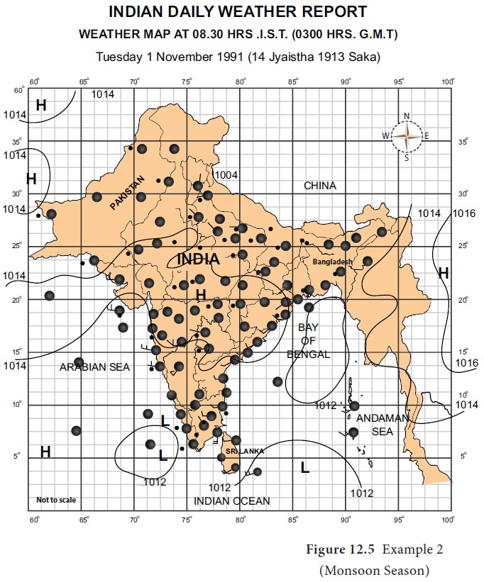
d.
Sky Cover: Sky cover is almost clear in North. In the South, it is partially cloudy. Sea condition is
moderate. Haze is found near north eastern part of India.
e.
Precipitation: Rain or thundershowers have occurred at a few places in coastal Andhra Pradesh, Tamil
Nadu and South Interior Karnataka at one or two places in Telangana,
Rayalasaema and Kerala.
f.
Departure of Maximum and Minimum temperature from
Normal: South west states record above
normal temperature, eastern states have below normal temperature, except of the
northwestern part of Rajasthan.
Conclusion:
Low pressure prevails in sea and High pressure inland, so it
indicates north east monsoon.
Related Topics