Exploring Continents: Africa, Australia and Antarctica | Chapter 7 | Geography | 8th Social Science - Questions with Answers | 8th Social Science : Geography : Chapter 7 : Exploring Continents: Africa, Australia and Antarctica
Chapter: 8th Social Science : Geography : Chapter 7 : Exploring Continents: Africa, Australia and Antarctica
Questions with Answers
Evaluation
I. Choose the correct
answer
1. The
southernmost tip of
Africa is ____________.
a. Cape Blanca
b. Cape Agulhas
c. Cape of Good Hope
d. Cape Town
[Answer:
(b) Cape Agulhas]
2. The manmade canal through an isthmus between Egypt and
Sinai Peninsula is
a. Panama Canal
b. Aswan Canal
c. Suez Canal
d. Albert Canel
[Answer:
(c) Suez Canal]
3. In respect of the Mediterranean climate, consider the
following statements and choose the correct answer.
1. The average rainfall is 15cm
2. The summers are hot and dry; winters are rainy.
3. Winters are cool and dry; Summers are hot and wet
4. Citrus fruits are grown
a. 1 is correct
b. 2 and 4 are correct
c. 3 and 4 are correct
d. All are correct
[Answer:
(b) 2 and 4 are correct]
4. The range which separates the west and east flowing
rivers in Australia is
a. Great Dividing Range
b. Himalayan range
c. Flinders range
d. Mac Donnell range
[Answer:
(a) Great Dividing Range]
5. Kalgoorile is famous for mining.
a. Diamond
b.Platinum
c. Silver
d. Gold
[Answer:
(d) Gold]
II Fill in the blanks
1. Atlas Mountain is located in North -
west Africa
continent.
2. Mt. Kilimanjaro is the highest peak of Africa.
3. Eucalyptus is the most common tree in Australia.
4. A temperate grass land of
Australia is called Downs.
5. Dakshin Gangotri is the first Indian research station in Antarctica.
III Match the
following
1.
Pinnacle - Equatorial forest
2. Krill - salt lake
3. Ostrich - small red fish
4. Lake Eyre - flightless bird
5. Jewel of the earth - pointed
limestone pillars
Answer:
1.
Pinnacle — Pointed limestone pillars
2. Krill
— small red fish
3.
Ostrich — flightless bird
4. Lake
Eyre — salt lake
5. Jewel
of the earth — Equatorial forest
IV Let us learn
1. Assertion
(A): Aurora is a curtain of colour
lights appear in the sky.
Reason (R): They are caused by magnetic storms in the upper atmosphere.
a. Both A and R are individually
true and R is the correct explanation for A.
b. Both A and R are individually
true but R is not the correct explanation for A
c. A is true but R is false.
d. R is true but A is false
[(a) Both
A and R is individually true and R is the correct explanation for A]
2. Assertion (A): A geological feature of Africa is the Great Rift Valley.
Reason (R): A Rift valley is a large crack in the earth’s surface
formed by tectonic activity.
a. Both A and R is individually true
and R is the correct explanation for A.
b. Both A and R are individually
true but R is not the correct explanation for A
c. A is true but R is false.
d. R is true but, A is false
[(a) Both
A and R is individually true and R is the correct explanation for A]
V Answer briefly
1. Why Africa is called a “Mother Continent”?
Answer: Africa is nicknamed as the ‘Mother Continent’ as it was the
oldest inhabited continent on Earth.
2. What are the important rivers of Africa?
Answer: The important rivers of Africa are R. Nile, R. Congo or Zaire,
R. Niger, R. Zambezi, Orange and R. Limpopo.
3. Name the physical division of Australia.
Answer: The Physical divisions of Australia are
(i) The Great Western Plateau
(ii) The Central Low lands
(iii) The Eastern High lands
4. Write about the nature of Antarctic continent.
Answer:
(i) Antarctica is a unique continent. It does not have a native
population.
(ii) There is no country in Antarctica.
(iii) It is the coldest continent with a permanent cover of ice.
(iv) It is the only continent called white continent.
5. Mention any four economic activities of Australia.
Answer: Agriculture, forestry, fishing mining, manufacturing, trade and
services are the major economic activities of Australia.
VI Distinguish between
1. Sahel and Sahara
Answer:
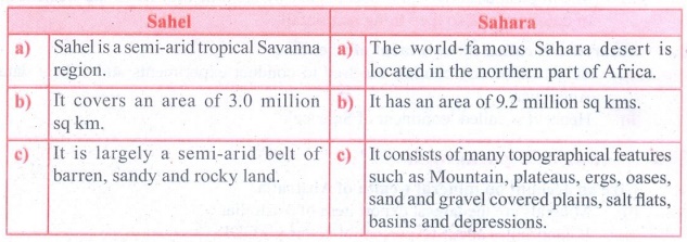
Sahel
a) Sahel is a semi-arid tropical Savanna region.
b) It covers an area of 3.0 million sq km.
c) It is largely a semi-arid belt of barren, sandy and rocky
land.
Sahara
a) The world-famous Sahara desert is located in the northern
part of Africa.
b) It has an area of 9.2 million sq kms.
c) It consists of many topographical features such as Mountain,
plateaus, ergs, oases, sand and gravel covered plains, salt flats, basins and
depressions.’
2. Western Antarctica and Eastern Antarctica
Answer:

Western
Antarctica
a) The West Antarctica faces the Pacific Ocean.
b) The Antarctic Peninsula which points towards the South
America shows that it is the continuation of the Andes mountain range.
Eastern
Antarctica
a) The East Antarctica faces the Atlantic and the Indian Oceans.
b) The Mt. Erebus in this region is an active volcano located in
the Ross Island.
3. Great Barrier Reef and Artesian Basin.
Answer:

Great
Barrier Reef
a) Great Barrier Reef is located in the north east of Australia.
b) It is formed by the tiny coral polyps..
c) It is about 2300 kms long.
Artesian
Basin
a) The Artesian Basins are regions on the earth’s surface where
water gushes out like a fountain.
b) It is found in the arid and semi - arid parts of Queensland.
c) It extents for 1.7 million square km.
VII Give reasons
1. Egypt is called the gift of the Nile.
Answer:
(i) Nile is the life line of Egypt
(ii) Without Nile the Egypt would have been a desert
(iii) So Egypt in the gift of the Nile.
2. Deserts are found in the western margins of continents.
Answer:
(i) Most of the world deserts are located in the western margins
of continents in the subtropics because the prevailing winds in the tropics are
tropical easterly winds.
(ii) The tropical easterly winds become dry by the time they
reach the western margins of continent and so they bring no rainfall.
3. Antarctica is called the continent of scientists
Answer:
(i) Scientists of any country are free to conduct experiments and
collect data from Antarctica.
(ii) Hence it is called ‘continent of Science’.
VIII Answer in a
paragraph
1. Give an account on mineral wealth of Australia.
Answer:
(i) Minerals are the largest export item of Australia.
(ii) It contributes about 10 percent of country’s GDP.
(iii) Australia is the world’s leading producer of bauxite,
limonite, rutile and zircon.
(iv) The Second largest producer of gold, lead, lithium,
manganese ore and zinc, the third largest producer of iron ore and uranium and
they fourth largest producer of black coal. (v) The coal belts of the country
stretches from New Castle to Sydney on the South Eastern Coast.
(vi) Iron ores are found mainly in southern and Western
Australia.
(vii) Petroleum and natural gas is obtained from Bass Strait and
west of Brisbane.
(viii) Uranium is mined in northern territory at Ram jungle and
Queensland.
(ix) Gold is mined in the western desert at Kalgoorlie and
Koolgarlie.
(x) Lead, Silver, Zinc, Manganese, Tungsten, Nickel and copper
are also mined in parts of Australia.
2. Describe the flora and fauna of Antarctica
Answer:
Flora and
Fauna:
(i) Since the temperature is below freezing point almost
throughout the year, no major vegetation is found in this continent.
(ii) Simple plants like algae, mosses, liverworts, lichens and
microscopic fungi can survive and grow in Antarctica.
(iii) Some algae live in the snow, while other plants grow on
the coastal rocky land that is ice free.
(iv) A few species of plants, such as plankton, algae and mosses
are seen in and around Antarctica’s fresh and saltwater lakes.
(v) Small red fish called krill are found in large shoals. It is
the food for many warm blooded sea animals.
(vi) The blue whale is the largest animal which feeds on
plankton. All these animals and birds have a thick layer of fat called blubber
which helps them to withstand the cold condition.
(vii) Penguin birds in Antarctica cannot fly. They have webbed
feet and flipper instead of wings. Small invertebrates are the only land
animals which lives in the continent.
3. Name the physical divisions of Africa and explain any
one.
Answer:
(1) Africa consists of mixture ofland forms such as mountains,
plateaus and plains. The following are the 8 major physical divisions of
Africa.
(a) Sahara
(b) Sahel
(c) Savanna
(d) The Great Rift Valley and the Great Lakes of Africa
(e) East African Highlands
(f) Swahili Coast
(g) The Congo Basin or Zaire Basin
(h) Southern Africa
(h)
Southern Africa
(i) Most part of the Southern Africa is a plateau region.
(ii) Drakensberg Mountain
is found in the eastern portion of the escarpment.
(iii) It extends from north east to south west for 1125 km.
(iv) Its highest peak is Thabana Ntlenyana (3482m) .
(v) This region is covered with grasslands known as‘Veld’.
(vi) Kalahari Desert lies in the south and Namib Desert is along
the south -west shore of Africa.
(vii) Kalahari Desert in this region is not actually a desert
but, a bushy scrubland situated between the Orange and Zambezi Rivers.
IX Map skill
Mark the following on the outline map of Africa and
Australia
Africa:
Equator, Atlas Mountain, Sahara, Eastern highlands, Mediterranean Sea, Atlantic
Ocean, Indian Ocean, Suez Canal, Mount Kilimanjaro,
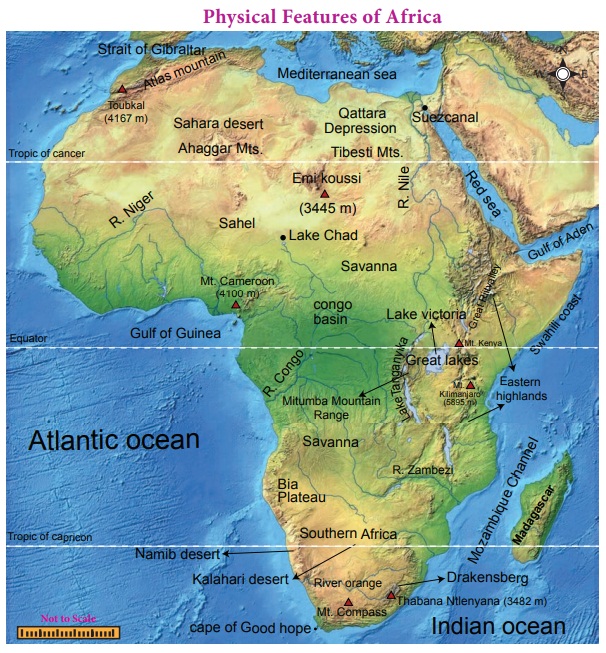
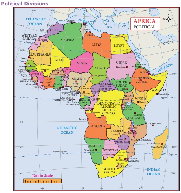
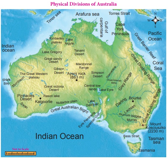
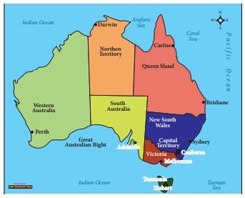
Australia: Great Dividing Range , Great barrier reef, Tasmania, tropic
of Capricorn, pacific ocean, Great Australian Sandy Desert, Indian ocean,
Sydney, Canberra
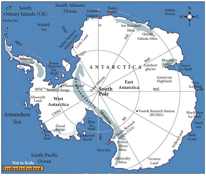
Antarctica:
X Activities
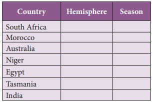
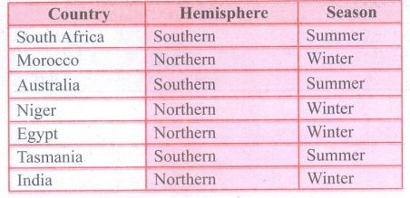
1. Find out the hemisphere and season during December for
the following countries
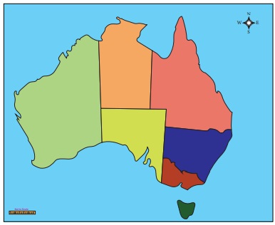

2. Label the different states of Australia in the following
map.
Related Topics