Geography - Measurement of distance between places | 11th Geography : Chapter 9 : Maps and Scale
Chapter: 11th Geography : Chapter 9 : Maps and Scale
Measurement of distance between places
Measurement
of distance between places
The linear features shown on the maps
can be classified into two broad categories, i.e. straight lines and erratic or
zigzag lines.
Straight line features
The measurement of straight line
features like roads, railway lines and canals is simple. It can be taken
directly with a pair of dividers or a scale placed on the map surface.
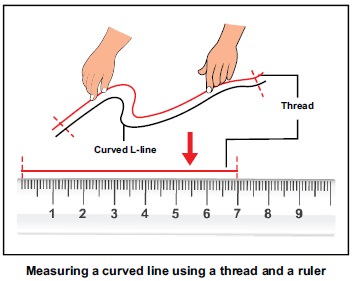
Erratic or zig zag lines
However, care should be taken to
measure distances , along erratic paths, such as roads, boundaries, coastlines,
rivers and streams. The distances along all such features can be measured by
placing a thread at the starting point and carrying it along the line up to the
end point. The thread is then stretched and measured to determine the distance.
It can also be measured by using a simple instrument called Rotameter. The
wheel of the ‘rotameter’ is moved along the route or line from start to end and
the reading noted down.
Example
a. Measure the straight line distance
between the towns Peel and Castle town.
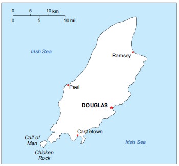
Step 1.
Measure the
distance between the towns Peel and Castle town with a scale or thread in cm.(example if it
is 2.9 cm)
Step 2.
Note the scale of
the map in this case 1 cm 5 10km
Step 3.
Multiply the
measured distance with the scale of the map.(2.9 3 10km 5 29km)
Answer
: The distance between the two urban centres is 29 km
b. Measure the irregular line
distance between the points A and B.
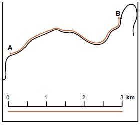
Step 1.
Measure the
distance between the two points with the help of a thread.
Step 2.
Place the thread on
a scale and read the measurement in cm.
(example if it is 3.2cm)
Step 3.
Note the scale of
the map in this case 1 cm 5 1 km
Step 4.
Multiply the
measured distance with the scale of the map. (3.2 3 1 km 5 3.2 km)
Answer
: The distance between the two points is 3.2 km
Exercise
1.
Measure the road and railway distance between your nearest town and
Chennai city from Tamil Nadu in your atlas.
2.
Measure the length of Tamil Nadu coastline .
3.
Measure distance between any two nearest villages in a topo sheet.
Related Topics