Chapter: Collision Avoidance Technologies, new invention technology, Research project papers,
Global Elevation Data Adaptive Compression System (GEDACS)
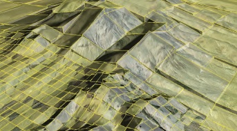
Global Elevation Data Adaptive Compression System (GEDACS)
Data-adaptive
algorithms are the critically enabling technology for Armstrong's GEDACS and
automatic collision avoidance system efforts. These Armstrong-developed
algorithms provide an extensive and highly efficient compression capability for
global-scale digital terrain maps (DTMs) along with a real-time decompression
capability to locally render map data. These terrain maps and decompression
algorithms are designed to be easily integrated into an aircraft's existing
onboard computing environment or into other mobile embedded environments, such
as smart phones or tablets, without the need for external data
download. The GEDACS
software package enables developers to create maps containing multiple
user-defined geographical areas with custom fidelities from a variety of data
sources. GEDACS provides this ability with a single, easy-to-use graphical user
interface; simple map definition; and data selection procedures.
Work to date: DTMs created with the GEDACS software have
been flown and tested on aircraft avionics systems and other mobile
embedded applications.
Looking ahead: Maps developed using
GEDACS are being considered for advanced automotive and space
applications that require large areas of digital terrain information.
Benefits
Efficient: Provides high compression
ratios (thousands to 1 for most map requirements)
Powerful: Integrates and processes
more than 250 billion separate pieces of terrain information into a single
decompressed DTM
Highly
configurable: Enables users to input requirements to create
compressed DTMs
Applications
Military and
civil aeronautics Unmanned aerial vehicles
Collision Avoidance Technologies
Researchers at Armstrong are dramatically improving upon
existing ground collision avoidance technology for aircraft. Controlled flight
into terrain remains a leading cause of fatalities in aviation, resulting in
roughly 100 deaths each year in the United States alone. Although warning
systems have virtually eliminated this problem for large commercial air
carriers, the problem still remains for fighter aircraft, helicopters, and
general aviation.
Armstrong innovators have been working with the U.S. Air Force
for more than 25 years to develop automatic col-lision avoidance technologies
for fighter aircraft that would reduce the risk of ground collisions, the
leading cause of fatalities in both military and general aviation. The result
of the collaboration is lifesaving technology that incorporates onboard digital
terrain mapping data with data-adaptive algorithms that predict impending
ground collisions.
Related Topics