Chapter: Civil : Engineering Geology : Structural Geology And Geophysical Method
Geophysical Investigations

GEOPHYSICAL INVESTIGATIONS
A.
Electrical Methods
Principle.
Ø All
electrical method are based on the fundamental fact that different materials of
earth' s crust
possess widely different electrical properties.
Ø Resistivity,
electrochemical activity and dielectrical constant are some of these properties
that are generally studied through these methods
Ø potential-drop
methods: the natural potential may be due to electrochemical reactions between
the solutions and the surrounding - subsurface rocks.
These reactions are not always of the same order throughout
the dimensions of the rock masses thereby creating a potential difference and
conditions for flow of current from one end to the other end.
Ø Elongated
ore bodies of magnetite and pyrite etc. are easily delineated by this method.
Ø Natural
electrical potential is measured with the help of nonpolarising electrodes
along definite directions and results are plotted in terms of potential
gradient along horizontal distances which are then interpreted.
Potential Drop Methods.
Ø These
include a variety of methods in which electrical current is artificially
introduced from an external source at certain points and then its flow through
subsurface materials recorded at different distances.
Ø In the
Equipotential Method two primary electrodes are inserted into the ground, 6-7
meters apart from each other, across which current is introduced.
Ø The
position of these primary electrodes remains fixed in the subsequent
investigations.
Potential
between these primary electrodes is determined with the help of two search
electrodes and points of equal potential found out along the entire region
under investigations, which are jointed to get equipotential lines.

Ø Under
normal conditions, that is, when the material below is of uniform nature,
electrically c the ec lines would be regular in character.
Ø But in
cases when the material w is not of uniform character (that is, it contains
patches of high or low conductivity), equipotential lines would show clear
distortions or irregularities which would include probable location of rock
masses of different characteritics.
Ø The
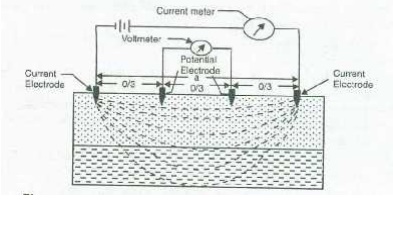
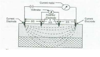
Resistivity Method is similar to equipotential method but in this case it is
the resistivity of the material of the subsurface which is determined and from
which important interpretations are made
Here
also, a known current is introduced through two electrodes- current electrodes,
which are inserted at some distances apart from each other.,

Investigation.
Ø The depth
of penetration of electrical current in these investigations is broadly equal
to although there are many conditions attached to this generalization.
Ø The
resistivity method envisages interpretation of the qualitative as well as
quantitative characters of the subsurface materials which are governed by two
basic principles
(i)
If material below is of uniform nature, the
resistivity values would be of regular character.
(ii)
If the material is non-uniform, that is, it
consists of layers or masses of different character, then these would be
indicated by irregularities or anomalies in the resistivity values.
(iii)
The depths at which these anomalies occur can be
calculated and also the nature of the subsurface material broadly understood.
Applications:
(a) In Prospecting: The
electrical methods have been successfully employed in delineation of ore
bodies occurring at shallower depths. For such surveys at great depths, these
are not of much help.
In table 1, some typical value-ranges of resistivity are
given. As may be seen, rocks exhibit a great variation ranging from as high
resistivity as > io ohms-meters in igneous rocks to as low as less than I
ohm-rn for clayey mans.
In Civil Engineering:
Resistivity methods have been widely used in engineering investigation
for determination of
Depth to the bed rock -as for
instance, in important projects like dams, buildings and bridge
foundations, where it would be desirable that the structure should rest on
sound hard rocks rather than on overburden or soil
Location of geological structures -like
folds, buried valleys, crushed and fractured zones due to shearing and
faulting.
Location
of Aquifers -and other water bearing zones
which could be easily interpreted on the basis of known resistivity
values of moisture rich rocks and dry rocks.
Related Topics