Globe | Term 3 Unit 2 | Geography | 6th Social Science - Exercises Questions with Answers | 6th Social Science : Geography : Term 3 Unit 2 : Globe
Chapter: 6th Social Science : Geography : Term 3 Unit 2 : Globe
Exercises Questions with Answers
Exercises
I Fill in
the blanks.
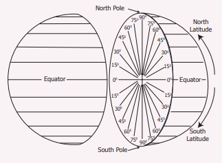
1. The line of latitude which is known as the
Great Circle is Equator.
2. The imaginary lines drawn horizontally on Earth
from the West to East are called Latitude.
3. The 90° lines of latitude on the Earth are
called Poles.
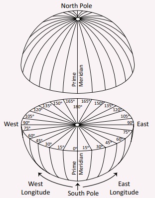
4. The Prime Meridian is also called Greenwich
Meridian.
5. The world is divided into 24
time zones.
II Choose
the best answer
1. The
shape of the Earth is _____________
a) Square
b) Rectangle
c) Geoid
d) Circle
Answer: c) Geoid
2. The
North Pole is
a) 90° N Latitude
b) 90° S latitude
c) 90° W Longitude
d) 90° E longitude
Answer: a) 90° N Latitude
3. The
area found between 0° and 180° E lines of longitude is called
a) Southern Hemisphere
b) Western Hemisphere
c) Northern Hemisphere
d) Eastern Hemisphere
Answer: d) Eastern Hemisphere
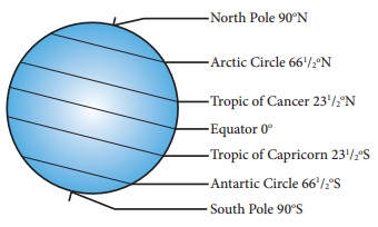
4. The 23
½° N line of latitude is called_____________
a) Tropic of Capricorn
b) Tropic of Cancer
c) Arctic Circle
d) Antarctic Circle
Answer: b) Tropic of Cancer
5. 180°
line of longitude is
a) Equator
b) International Date Line
c) Prime Meridian
d) North Pole
Answer: b) International Date Line
6. The
Sun is found overhead the Greenwich Meridian at
a) 12 midnight
b) 12 noon
c) 1 p.m.
d) 11 a.m.
Answer: b) 12 noon
7. A day
has _____________.
a) 1240 minutes
b) 1340 minutes
c) 1440 minutes
d) 1140 minutes
Answer: c) 1440 minutes
8. Which
of the following lines of longitude is considered for the Indian Standard Time?
a) 82½° E
b) 82½° W
c) 81½° E
d) 81½° W
Answer: a) 82 ½ ° E
9. The
total number of lines of latitude are
a) 171
b) 161
c) 181
d) 191
Answer: c) 181
10. The
total number of lines of longitude are
a) 370
b) 380
c) 360
d) 390
Answer: c) 360
III Circle
the odd one
1. North Pole, South Pole, Equator, International
Date Line.
North Pole, South Pole, Equator, (international
Date Line)
2. Tropic of Capricorn, Tropic of Cancer, Equator,
Prime Meridian.
Tropic of Capricorn, Tropic of Cancer, Equator, (Prime
Meridian.)
3. Torrid Zone, Time Zone, Temperate Zone, Frigid
Zone
Torrid Zone, (Time Zone,) Temperate Zone, Frigid Zone
4. Royal Astronomical observatory, Prime Meridian,
Greenwich Meridian, International Date Line.
(Royal Astronomical observatory,) Prime
Meridian, Greenwich Meridian, International Date Line.
5. 10° North, 20° South, 30° North, 40° West
10° North, 20° South, 30° North, (40° West )
IV Match the
following.
A / B
1. 0° line
of latitude - Pole
2. 0° line of longitude- International Date Line
3. 180° line of longitude- Greenwich
4. 90° line
of latitude- Equator
A B
0° line of
latitude - Equator
0° line of
longitude - Greenwich
180° line of
longitude - International Date line
90° line of
latitude - Pole
V Examine
the following statements
1. The Earth is spherical in shape.
2. The shape of the Earth is called a geoid.
3. The Earth is flat.
Look at the options given below and choose
the correct answer
a) 1 and 3 are correct
b) 2 and 3 are correct
c) 1 and 2 are correct
d) 1,2 and 3 are correct
Answer: c) 1 and 2 are correct
VI Examine
the following statements
Statement I : The
lines of latitude on Earth are used to find the location of a place and define
the heat zones on Earth.
Statement II : The
lines of longitudes on Earth are used to find the location of a place and to
calculate time.
Choose the correct option
a) Statement I is correct; II is wrong
b) Statement I is wrong; II correct
c) Both the statements are correct
d) Both the statements are wrong
Answer: c) both the statements are correct
VII Name the
following
1. The
imaginary lines drawn horizontally on Earth. Latitudes
2. The
imaginary lines drawn vertically on Earth. Longitude
3. The
three dimensional model of the Earth. Globe
4. India
is located in this hemisphere based on lines of longitude. Eastern hemisphere
5. The
network of lines of latitude and longitude. Earth
Grid or Geographic grid
VIII Answer
briefly
1. What
is a geoid?
The Earth which is spherical, is
flat at the poles and bulges at the Equator. The Earth cannot be compared with
any other geometrical shape as it has a very unique shape. Hence, its shape is
called a geoid.
2. What
is local time?
When the sun is overhead on a
particular line of longitude, it is 12 noon at all the places located on that
line of longitude. This is called local time.
3. How
many times would the sun pass overhead a line of longitude?
The Sun passes overhead a line of
longitude only once in a day.
4. What
are lines of latitude and longitude?
The imaginary lines drawn horizontally
from the East to West on the globe and maps are called lines of latitude or
parallels. The imaginary lines drawn vertically from the North to South on the
globe and maps are known as lines of longitude or meridians.
5. Name
the four hemispheres of the Earth.
1. Northern Hemisphere
2. Southern Hemisphere
3. Eastern Hemisphere
4. Western Hemisphere
IX Give
reasons
1. The 0°
line of longitude is called the Greenwich Meridian.
It passes through Greenwich
2. The
regions on Earth between North & South lines of latitude (66 ½°) and poles
(90°) is called Frigid Zone
From the Arctic Circle (66 ½ °N) to
the North Pole (90°N) and from the Antarctic Circle (66 ½ °S) to the South Pole
(90°S), the Sun’s rays fall further inclined, throughout the year. The temperature
is very low. Hence, this region is known as Frigid Zone.
3. The
International Date Line runs zigzag.
The International Date Line is not
straight. If the line is drawn straight, two places in the same country would
have different dates. So the International Date Line is found zigzag in certain
places to avoid confusion.
X Answer in
detail
1. What
are the uses of globe?
The globe helps us to see the shape
of the Earth as a whole. We can learn the unique features of the Earth using
the globe.
2. How
are the hemispheres divided on the basis of lines of latitude and longitude?
Explain with diagrams.
Northern Hemisphere
: The area of the Earth found between the Equator (00) and the
North Pole (90°N) is called the Northern Hemisphere.
Southern Hemisphere
: The area of the Earth from the Equator (0°) to the South Pole
(90°S) is called the Southern Hemisphere.
Eastern Hemisphere
: The part of the Earth between the 0° line of longitude and the
180° East line of longitude is known as the Eastern Hemisphere.
Western Hemisphere: The part of the Earth from 0° line of longitude to 180° West
line of longitude is called Western Hemisphere.
3. What
are the significant lines of latitude? Explain the zones found between them.
The earth rotates on its axis at an inclination of 23 ½°. It also revolves around the sun while
rotating. Based on the angle at which the sun's rays fall on the earth, certain
lines of latitude gain significance.
The Sun's rays do not fall equally on all parts of the earth.
They fall vertically over the Equator and slanting towards the poles. Thus, all
the places on earth do not have the same amount of temperature. Based on the
amount of heat received from the Sun, the lines of latitude help in dividing
the earth into different climatic zones.
Torrid Zone: The region from the Equator towards the Tropic of Cancer (23 ½
°N) and the Tropic of Capricorn (23 ½ °S) is called the Torrid Zone. The Sun's
rays fall vertically over this region and the average temperature is very high.
Hence this region is known as the Torrid Zone.
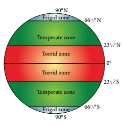
Temperate Zone : From the Tropic of Cancer (23 ½ °N) to the Arctic Circle (66 ½
°N) and from the Tropic of Capricorn (23 ½°S) to the Antarctic Circle (66 ½ °S),
the Sun's rays fall slantingly. Moderate temperature prevails in this region.
Hence, this region is called Temperate Zone.
Frigid Zone : From the Arctic Circle (66 ½ °N) to the North Pole (90°N) and
from the Antarctic Circle (66 ½ °S) to the South Pole (90°S), the Sun's rays
fall further inclined, throughout the year. The temperature is very low. Hence,
this region is known as Frigid Zone.
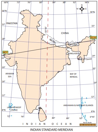
4.
Explain: Indian Standard Time.
The longitudinal extent of India is from 68°7' E to 97°25' E. As
many as twenty nine lines of longitude pass through India. Having 29 standard
time is not logical. Hence 82 ½ ° E line of longitude is observed as the Prime
Meridian to calculate the Indian Standard Time (IST).
XI Activity
There are five positions marked on the grid given
below. Look at them carefully and fill the blanks with reference to the lines
of latitude and longitude. The first one is done for you.
1. The latitudinal and longitudinal reference of
point A 40° N 30° W
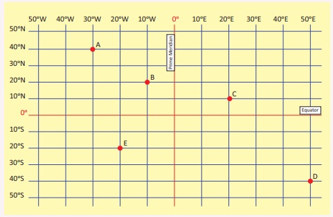
2. The latitudinal and longitudinal reference of
point B 10°W
3. The latitudinal and longitudinal reference of
point C 20°E
4. The latitudinal and longitudinal reference of
point D 50°E
5. The latitudinal and longitudinal reference of
point E 20°W
Related Topics