Chapter: Civil : Railway Airport Harbour Engineering : Railway Engineering : Alignment of Railway Lines
Selection of a Good Alignment of Railway Lines

Selection of a Good Alignment
Normally, a direct straight route connecting two points
is the shortest and most economical route for a railway line, but there are
practical problems and other compulsions which necessitate deviation from this
route. The various factors involved is the selection of a good alignment for a
railway line are given below.
Choice of Gauge
The
gauge can be a BG (1676 mm), an MG (1000 mm), or even an NG (762 mm). As per
the latest policy of the Government of India, new railway lines are constructed
on BG only.
Obligatory or Controlling Points
These are the points
through which the railway line must pass due to political, strategic, and
commercial reasons as well as due to technical considerations. The following
are obligatory or controlling points.
Important cities and
towns These are mostly intermediate important towns,
cities, or places which of commercial, strategic, or political
importance.
Major bridge sites and
river crossings The construction of major bridges for
large rivers is very expensive and suitable bridge sites become obligatory
points for a good alignment.
Existing passes and
saddles in hilly terrain Existing passes and saddles should
be identified for crossing a hilly terrain in order to avoid deep cuttings
and high banks.
Sites for tunnels The
option of a tunnel in place of a deep cut in a hilly terrain is better
from the economical viewpoint. The exact site of such a tunnel becomes an
obligatory point.
Topography of the Country
The alignment of a new
railway line depends upon the topography of the country it traverses. The
following few situations may arise.
Plane alignment When
the topography is plane and flat, the alignment presents no problems and
can pass through obligatory points and yet have very easy gradients.
Valley alignment The
alignment of a railway line in valley is simple and does not pose any
problem. If two control points lie in the same valley, a straight line is
provided between these points with a uniform gradient.
Cross-country alignment
The
alignment of a railway line in such terrain crosses the watersheds of
two or more streams of varied sizes. As the levels vary in cross-country, the
gradients are steep and varying and there are sags and summits. The controlling
or obligatory points for cross-country alignment may be the lowest saddles or
tunnels. It may be desirable to align the line for some length along the
watersheds so that some of the drainage crossings may be avoided.
Mountain alignment The
levels in mountains vary considerably, and if normal alignment is
adopted, the grades would become too steep, much more than the ruling gradient
(allowable gradient). In order to remain within the ruling gradient, the length
of the railway line is increased artificially by the 'development process'. The
following are the standard methods for the development technique:
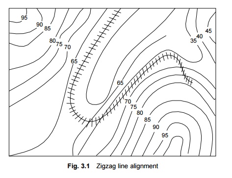
Zigzag line method In
this method, the railway line traverses in a zigzag alignment (Fig.
3.1) and follows a convenient side slope which is at nearly right angles to the
general direction of the alignment. The line then turns about 180 o in a
horseshoe pattern to gain height.
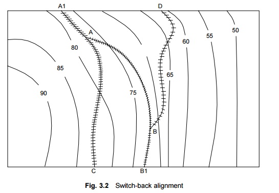
Switch-back
method In the case of steep side slopes, a
considerable gain in elevation is accomplished the switch-back
method (Fig. 3.2). This method involves a reversal of direction achieved by a
switch, for which the train has to necessarily stop. The switch point is
normally located in a station yard. In Fig. 3.2, A and B are two switches and A1
and B1 are two buffer stops. A train coming from D will stop at B1
and move in back gear to line BA. It will stop at A1 again and then
follow the line AC.


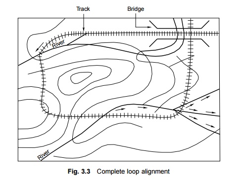
Spiral
or complete loop method This method is used in
a narrow valley where a small bridge or viaduct has been
constructed at a considerable height to span the valley (Fig. 3.3). In this
case, normally a complete loop of the railway line is constructed, so that the
line crosses the same point a second time at a height through a flyover or a
tunnel.

Geometrical Standards
Geometrical standards
should be so adopted as to economize as much as possible as well as provide
safety and comfort to passengers. This can be done by adopting gradients and
curves within permissible limits. Transition as well as vertical curves should
be used to provide better comfort and safety.
Geological Formation
The alignment should be
so selected that it normally runs on good and stable soil formation as far as
possible. Weak soil and marshy land present a number of problems including
those of maintenance. Though rocky soil, provides a stable formation, it is a
costly proposal.
Effect of Flood and Climate
The
alignment should normally pass through areas which are not likely to be
flooded. The climatic conditions should also be taken into consideration for
alignment. In hot climate and sandy areas, the alignment should pass by those
sides of sand dunes that face away from the direction of the wind. Similarly,
in cold regions, the alignment should pass by those sides of hills that face
away from the direction of the wind. A sunny side is more desirable.
Position of Roads and Road Crossings
A railway line should cross a road at right angles
so as to have a perpendicular level crossing and avoid accidents.
Proximity of Labour and Material
The availability and proximity of local labour and
good and cheap building material should also be considered when deciding the
alignment.
Location of Railway Stations and Yards
Railway stations and yards should be located on
level stretches of land, preferably on the outskirts of a town or village so as
to have enough area for the free flow of traffic.
Religious and Historical Monuments
The alignment should avoid religious and historical
monuments, as it is normally not possible to dismantle these buildings.
Cost Considerations
The alignment should be such that the cost of
construction of the railway line is as low as possible. Not only the initial
cost of construction but also the maintenance cost should be as low as
possible. For this purpose, the alignment should be as straight as possible,
with least earthwork, and should pass through terrain with good soil.
Traffic Considerations
The alignment should be so selected that it attracts
maximum traffic. In this context, traffic centres should be well planned; so
that the railway line is well patronized and the gross revenue arising out of
traffic receipts is as high as possible.
Economic Considerations
Keeping in mind the various considerations, it
should be ensured that the alignment is overall economical. For this purpose,
various alternate alignments are considered and the most economical one, which
is cost effective and gives the maximum returns is chosen.
The
maximum annual return (![]() ) is
calculated by the formula
) is
calculated by the formula

where R is the gross revenue earned by the
railway line and E denotes the annual running expenses.
It
may be noted here that R depends upon the route that proves to be
advantageous when taking traffic into consideration and, therefore, should be
given due weightage. The other way to maximize the annual return is to have
sound and economical construction work so as to reduce the annual running
expenses. A suitable balance has to be achieved between construction cost and
operating expenses.
Political Considerations
The
alignment should take into account political considerations. It should not
enter foreign soil and should preferably be away from common border areas.
Related Topics