Chapter: Civil Surveying : Levelling and Applications
Proceed profile leveling or longitudinal sectioning in the field
Proceed profile leveling or
longitudinal sectioning in the field.
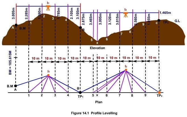
Profile Leveling
Profile leveling is a method of
surveying that has been carried out along the central line of a track of land
on which a linear engineering work is to be constructed/ laid. The operations
involved in determining the elevation of ground surface at small spatial
interval along a line is called profile leveling.
Stations
The line along which the profile is
to be run is to be marked on the ground before taking any observation. Stakes
are usually set at some regular interval which depends on the topography,
accuracy required, nature of work, scale of plotting etc. It is usually taken
to be 10 meter. The beginning station of profile leveling is termed as 0+00.
Points at multiples of 100m from this point are termed as full stations.
Intermediate points are designated as pluses.
Procedure
In carrying out profile leveling, a
level is placed at a convenient location (say I1) not necessarily along the
line of observation. The instrument is to be positioned in such a way that
first backsight can be taken clearly on a B.M. Then, observations are taken at
regular intervals (say at 1, 2, 3, 4) along the central line and foresight to a
properly selected turning point (say TP1). The instrument is then re-positioned
to some other convenient location (say I2). After proper adjustment of the
instrument, observations are started from TP1 and then at regular intervals
(say at 5, 6 etc) terminating at another turning point, say TP2 . Staff
readings are also taken at salient points where marked changes in slope occur,
such as that at X.
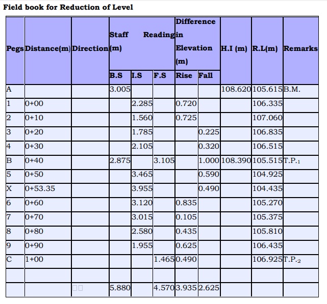
Field book for Reduction of Level
Related Topics