Term 1 Unit 3 | History | 6th Social Science - Indus Civilisation | 6th Social Science : History : Term 1 Unit 3 : Indus Civilisation
Chapter: 6th Social Science : History : Term 1 Unit 3 : Indus Civilisation
Indus Civilisation
Unit
3
Indus
Civilisation
Learning Objectives
* To
learn how Indus Civilisation is related to other contemporary civilisations.
* To
understand the urban nature of the Indus Civilisation.
* To
know the lifestyle of the people of this civilisation.
* To
identify and study the major sites of Indus Civilisation
* To
mark their geographical location in maps.
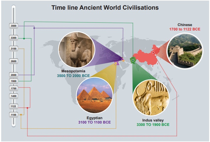
All these civilisations
were established only in places near the rivers, most commonly along their banks.
Initially, people lived
in groups. Then they formed communities out of these groups. Then evolved the societies
which in due course become civilisations.
Why did people settle near rivers?
People preferred to settle near
the rivers for the reasons given below.
* The soil is fertile.
* Fresh water is available for drinking, watering
livestock and irrigation.
* Easy movement of people and goods is possible.
Discovery of a lost city – Harappa
The ruins of Harappa
were first described by the British East India Company soldier and explorer Charles
Masson in his book. When he visited the North-West Frontier Province which is now
in Pakistan, he came across some mysterious brick mounds. He wrote that he saw a
“ruined brick castle with very high walls and towers built on a hill”. This was
the earliest historical record of the existence of Harappa.
In 1856 when engineers
laid a railway line connecting Lahore to Karachi, they discovered more understanding
their significance, they used the bricks for laying the rail road.
In the 1920s archaeologists
began to excavate the cities of Harappa and Mohenjo-Daro. They unearthed the remains
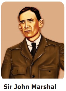
of these long-forgotten cities. In 1924 the Director General of ASI, Sir John Marshall,
found many common features between Harappa and Mohenjo-Daro. He concluded that they
were part of a large civilisation.
Some slight differences
are found in the earthenwares of Harappa and Mohenjo-Daro. This made the researchers
conclude that Harappa was older than Mohenjo-Daro.
The Archaeological Survey
of India (ASI) was started
in 1861 with Alexander Cunningham as Surveyor. Its headquarters
is located in New Delhi.
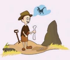
How do archaeologists explore a lost city?
Archaeologists
study the physical objects such as bricks, stones or bits of broken pottery (sherds)
to ascertain the location of the city and time that it belong to.
They search
the ancient literary sources for references about the place.
They look
at aerial photographs of the excavation sites or cities to understand the topography.
To see
under the ground, they may use a magnetic scanner
The presence
and absence of archeological remains can be detected by RADAR and Remote Sensing
Methods.
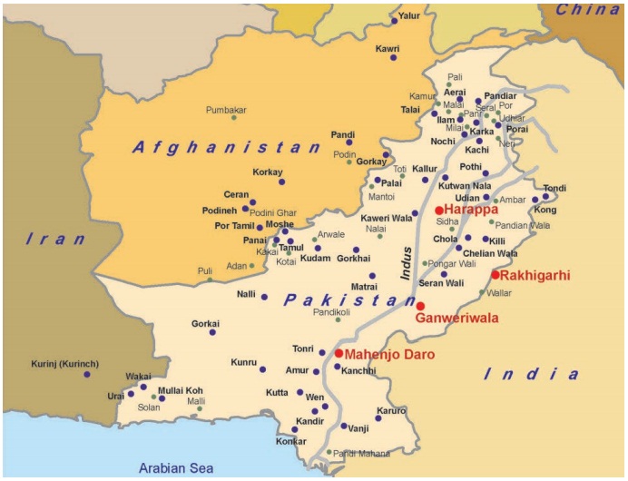
Sites in Indian borders
Archaeologists found
major Harappan sites within Indian borders.
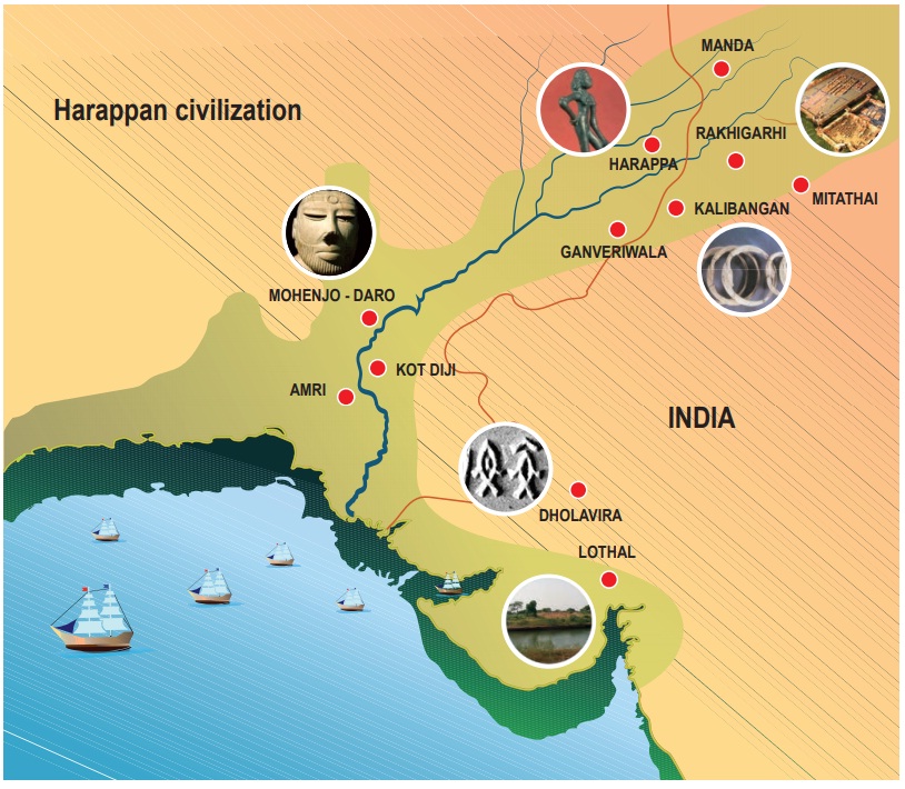
Observe
the picture and fill the tabular column.

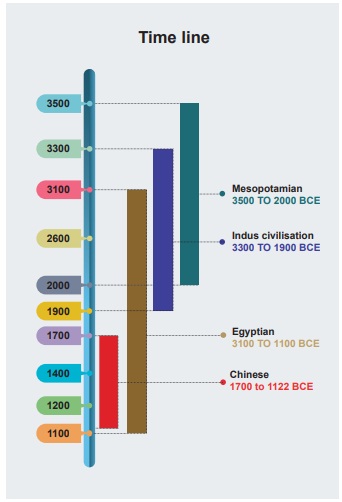
Time Span of Indus Civilisation
Geographical range:
South Asia Period: Bronze Age Time: 3300 to1900 BCE (determined using the radiocarbon
dating method) Area: 13 lakh sq.km Cities: 6 big cities Villages: More than 200

Urban Civilisation
Harappan civilisation
is said to be urban because of the following reasons.
• Well-conceived town planning
• Astonishing masonry and architecture
• Priority for hygiene and public health
• Standardised
weights and measures
• Solid
agricultural and artisanal base
Unique Features of Harappan Civilisation
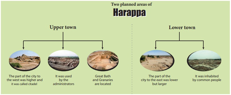
Town planning is a unique
feature of the Indus Civilisation. The Harappan city had two planned areas.
Mehergarh
– the Precursor to Indus Civilisation
Mehergarh is a Neolithic site. It is located near the Bolan Basin of Balochistan in Pakistan. It is one of the earliest sites known. It shows evidence of farming and herding done by man in very early times. Archaeological evidence suggests that Neolithic culture existed in Mehergarh as early as 7000 BCE.
Streets
and Houses

* The streets are observed to have a grid
pattern. They were straight running from north to south and east to west and intersected
each other at right angles.
* The roads were wide with rounded corners.
* Houses were built on both sides of the street.
The houses were either one or two storeys.
* Most of the houses had many rooms, a courtyard
and a well. Each house had toilets and bathrooms.
* The houses were built using baked bricks and mortar.
Sun-dried bricks were also used. Most of the bricks were of uniform size. Roofs
were flat.
• There is no conclusive evidence of the presense of palaces or places of worship.
why burnt bricks are used in construction?
They are
strong, hard, durable, resistant to fire and will not dissolve in water or rain.
Info Bits
Bronze Age
It is
a historical period characterised by the use of articles made of bronze.
Drainage System
* Many of these cities had covered drains.
The drains were covered with slabs or bricks.
* Each drain had a gentle slope so that water
could flow.
* Holes were provided at regular intervals
to clear the drains.
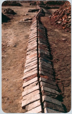
* House drains passed below many lanes
before finally emptying into the main drains.
* Every house had its own soak pit, which
collected all the sediments and allowed only the water to flow into the street drain.
The Great Bath
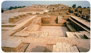
* The great bath was a large, rectangular tank
in a courtyard. It may be the earliest example of a water-proof structure.
* The bath was lined with bricks, coated with
plaster and made water-tight using layers of natural bitumen.
* There were steps on the
north and south leading into the tank. There were rooms on three sides.
* Water was drawn from the well located
in the courtyard and drained out after use.
The Great Granary
* The granary was a massive building with
a solid brick foundation.
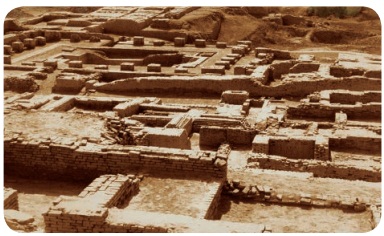
* Granaries were used to store food grain.
* The remains of wheat, barley, millets, sesame
and pulses have been found there.
A granary
with walls made of mud bricks, which are still in a good condition, has been discovered
in Rakhigarhi, a village in Haryana, belonging to Mature Harappan Phase.
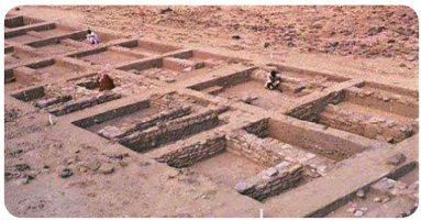
The Assembly Hall
The Assembly Hall was
another huge public building at Mohenjo-Daro. It was a multi-pillared hall (20 pillars
in 4 rows to support the roof).
Trade and Transport
* Harappans were great traders.
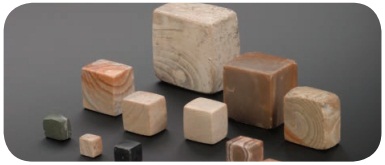
* Standardised weights and measures were
used by them. They used sticks with marks to measure length.
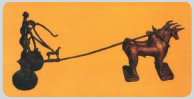
* They used carts with spokeless solid wheels.
* There is evidence for extensive maritime
trade with Mesopotamia. Indus Seals have been found as far as Mesopotamia (Sumer)
which are modern-day Iraq, Kuwait and parts of Syria.
* King Naram-Sin of Akkadian Empire (Sumerian)
has written about buying jewellery from the land of Melukha (a region of the Indus
Valley).
* Cylindrical seals similar to those found in
Persian Gulf and Mesopotamia have also been found in the Indus area. This shows
the trade links between these two areas.
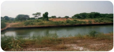
A naval dockyard has
been discovered in Lothal in Gujarat. It shows the maritime activities of the Indus
people.
Dockyard at Lothal
Lothal is situated on
the banks of a tributary of Sabarmati river in Gujarat.
Leader in Mohenjo-Daro
* A sculpture of a seated
male has been unearthed in a building, with a head band on the forehead and a smaller
ornament on the right upper arm.
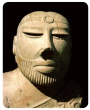
* His hair is carefully combed, and beard finely
trimmed.
* Two holes beneath the ears suggest that
the head ornament might have been attached till the ear.
* The left shoulder is covered with a shawl-like
garment decorated with designs of flowers and rings.
* This shawl pattern is used by people even
today in those areas.
Technology
* Indus people had developed a system of
standardised weights and measures.
* Ivory scale found in Lothal in Gujarat is
1704mm (the smallest division ever recorded on a scale of other contemporary civilisations).
Info Bits
The word
‘civilisation’ comes from the ancient Latin word civis, which means ‘city’.
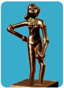
This little
statue was found at Mohenjo-Daro. When Sir John Marshall saw the statuette known
as the dancing girl, he said, “When I first saw them I found it difficult to believe
that they were pre-historic modeling. Such as this was unknown in the ancient worlds
up to the age of Greece. I thought that these figures had found their way into levels
some 3000 years old to which they properly belonged”.
KVT Complex (Korkai-Vanji-Thondi)
spread over Afghanistan and Pakistan has many places, names of those were mentioned
in sangam literature.
Korkai,
Vanji, Tondi, Matrai, Urai and Kudalgarh are the names of places in Pakistan.
Gurkay
and Pumpuhar in Afghanistan are related to the cities and ports mentioned in the
Sangam Age. The names of the rivers Kawri and Poruns in Afghanistan and the rivers
Kaweri Wala and Phornai in Pakistan also occur in the Sangam literature.
Do you know The hidden treasures of the Indus civilization
Inscriptions (written
in a script of those times) can provide us information about customs, practices
and other aspects of any place or time. So far, the Indus script has not been deciphered.
Therefore, we must look for other clues to know about the Indus people and their
lifestyle.
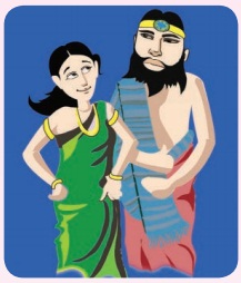
Apparel
* Cotton fabrics were
in common use.
* Clay spindles unearthed
suggest that yarn was spun.
* Wool was also used.
Love and peace
* Settlements were
built on giant platforms and elevated grounds.
* The Indus Civilisation
seems to have been a peaceful one.
* They displayed their
status with garments and precious jewellery.
* They displayed their
status with garments and precious jewellery.
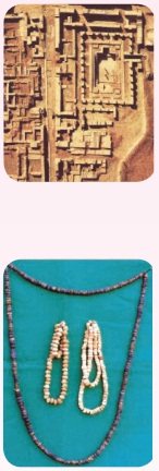
Ornaments
* Ornaments were popular
among men and women.
* They adorned themselves
with necklaces, armlets, bangles, finger rings, ear studs and anklets.
* The ornaments were
made of gold, silver, ivory, shell, copper, terracotta and precious stones.
Iron was unknown to people of Indus.
Indus people used
the red
quartz stone called Carnelian to design jewellery.
Info Bits
Copper
was the first metal discovered and used by humans.
Who Governed them?
Historians believe that
there existed a central authority that controlled planning of towns and overseas
trade, maintenance of drainage and peace in the city.
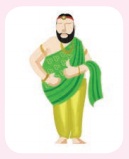
Occupation
* The main occupation
of the Indus Civilisation people is not known. However, agriculture, handicrafts,
pottery making, jewellery making, weaving, carpentry and trading were practiced.
* There were merchants,
traders and artisans.
* Rearing of cattle
was another occupation.
* People of those times
knew how to use the potter’s wheel.
* They reared domesticated
animals.
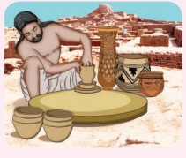
Pottery
* Pottery was practiced
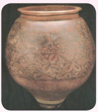
using the potter’s wheel. It was well fired. Potteries were red in colour with beautiful
designs in black.
* The broken pieces
of pottery have animal figures and geometric designs on it.
Religious Belief
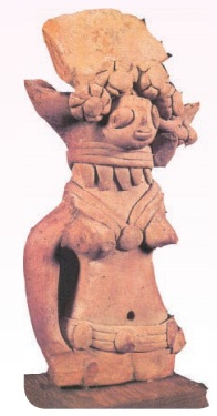
We don’t have any evidence
pointing to specific deities or their religious practices. There might have been
worship of Mother Goddess (which symbolized fertility), which is concluded based
upon the excavation of several female figurines.
Toy Culture
Toys like
carts, cows with movable heads and limbs, clay balls, tiny doll, a small clay monkey,
terracotta squirrels eating a nut, clay dogs and male dancer have been found.
They made
various types of toys using terracotta, which show that they enjoyed playing.

Info Bits
The earliest
form of writing was developed by Sumerians.
What happened to Harappans?
By 1900 BCE, the Harappan
culture had started declining. It is assumed that the civilisation met with
* repeated floods
* ecological changes
* invasions
* natural calamity
* climatic changes
* deforestation
* an epidemic
Archaeological site at
Mohenjo-Daro has been declared as a World Heritage Site by UNESCO.
Radiocarbon Dating
Method: A Standard Tool for Archaeologists
Also known as C14 method,
the radiocarbon method uses the radioactive isotope of carbon called carbon14
to determine the age of an object.
General Facts about
Indus Civilisation
* It is among the oldest
in the world.
* It is also the largest
among four ancient civilisations.
* The world’s first
planned cities are found in this civilisation.
* The Indus also had advanced sanitation and drainage
system.
* There was a high sense
of awareness on public health.
Summary
* When man began to live in a settled life, it marked
the dawn of civilisation.
* River valleys were responsible for the growth
of civilisation.
* Harappan culture was mainly urban innature.
* Cities were well planned
with covered drainage and straight wide roads, cutting each other at right angles.
* The people of that time had great engineering
skills.
* The Great Bath is one of the earliestpublic
tank.
* The civilisation extended from: Makran coast of
Baluchistan in west Ghaggar-Hakra river valley in east Maharashtra in the south
GLOSSARY
1. Archaeologist _ one who studies the remains of the past by excavations
and explorartion
2. Excavate _ to uncover by digging away
3. Urbanisation _ population shift from rural areas to urban areas
4. Pictograph _ a record consisting of pictorial symbols
5. Steatite _ a soft variety of talc stone
6. Spindles _ a device used to spin clothes
7. Bitumen _ water-proof tar
8. Artefact _ an object shaped by human craft of historical interest
9. Dockyard _ an enclosed area of water in a unloading and repair of ships.
10. Seal _
an embossed emblem, figure or symbol
Elsewhere in the World
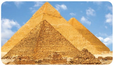
The Great Pyramid of Giza built by king Khufu in 2500 BCE, built with lime stone (15 tons each)
Mesopotamia (Sumerian
period) Ur Ziggurat built by king Ur Nammu in Honour of the Moon God Sin

Abu Simbel Site of two temples built by Egyptian king
Ramises II
Internet Resources
1. http://www.thenagain.info/webchron/india/harappa.html
2. http://www.archaeologyonline.net/artifact/harappa-mohenjodaro.html
3. http://en.m.wikipedia.org
4. www.harappa.com
Related Topics