Geography - Gradation | 9th Social Science : Geography : Lithosphere – II Exogenetic Processes
Chapter: 9th Social Science : Geography : Lithosphere – II Exogenetic Processes
Gradation
Gradation
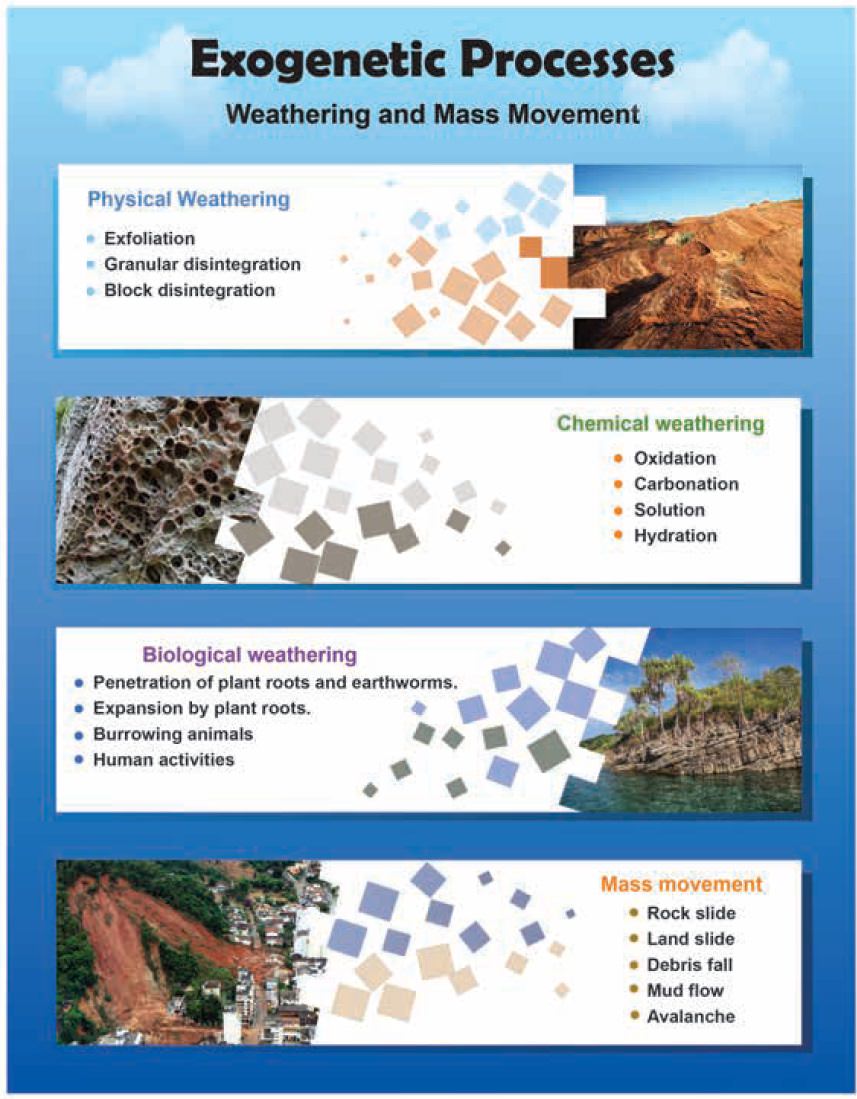
Gradation is the process of levelling of the land by means of natural agents like rivers, ground water, winds, glaciers, and sea waves. These agents produce various gradational relief features in due course of time. Gradation takes place in two ways: degradation and aggradation Degradation or denudation is the wearing down of the land surface by various natural agents.
Aggradation
is
building up of landforms due to
natural agents.
Gradation
= Erosion + Transportation
+
Deposition
Agents of Gradation
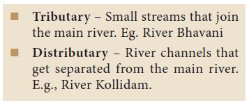
Running water (River)
The work of running water (rivers) is the most
extensive among all the other agents of gradation. Rivers originate on higher
landforms like, mountains, hills and plateaus that receive water from various
sources like the rain, glaciers, springs, lakes, etc.The place where the river
originates is called its source and where it joins the sea is known as its
mouth.
The primary functions of a river are (i) erosion (ii) transportation and deposition. The work of a river depends on various factors such as volume of water, velocity of the river, slope of land, load of sediment and structure of rock, and load of sediment.
Courses of River:
Rivers generally originate from mountains and end
in a sea or lake. The whole path that a river flows through is called its
course. The course of a river is divided into:
i.
The upper course
ii.
The middle course and
iii.
The lower course
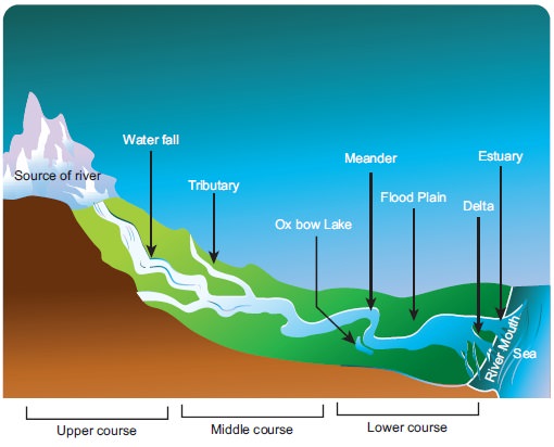
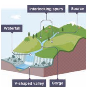
i. The Upper Course
Erosion is the most dominant action of river in the upper course. In this course, a river usually tumbles down the steep mountain slopes. The steep gradient increases the velocity and the river channel performs erosion with great force to widen and deepen its valley. The land features carved by a river in its upper course are V- shaped valleys, gorges, canyons, rapids, pot holes, spurs, and waterfalls.
ii. The Middle Course-
The river enters the plain in its middle course.
The volume of water increases with the confluence of many tributaries and thus
increases the load of the river. Thus, the predominant action of a river is transportation. Deposition also occurs
due to the sudden decrease in velocity. The river in the middle course develops
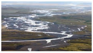
some typical landforms like alluvial fans, flood plains, meanders, ox-bow lakes
etc.,
iii. The Lower course
The river, moving downstream across a broad, level
plain is loaded with debris, brought down from its upper and middle courses.
Large deposits of sediments are found at the level bed and the river, splits
into a number of channels called distributaries. The main work of the river
here is deposition and it develops
typical landforms like delta and estuary.
Erosional Landforms of River
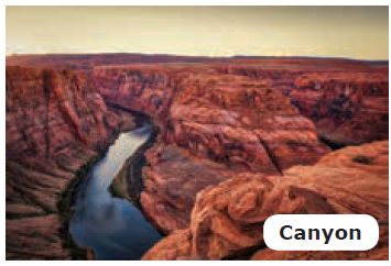
Gorges and Canyons:
When the river flows through a mountainous region
made up of hard rocks, it forms a valley with almost vertical sides called
gorge. In India, deep gorges have been formed by Brahmaputra and Indus in the
Himalayas.
A deep gorge with steep sides that runs for
hundreds of kilometres is referred to as canyon e.g. Grand Canyon of the river
Colorado in the U.S.A
Waterfall
When a river flows in a region where hard rocks lie
over soft rocks horizontally, the soft rocks get eroded quickly and the hard
rocks projects outwards. Thus, the river falls vertically from a steep slope to
form a waterfall. When the water
falls with great force, it erodes the rock material beneath and creates a
depression called a plunge pool.
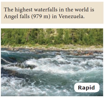
Shallow fast flowing water in a
stream is called a rapid
V-shaped valley
A ‘V’- shaped valley is formed by the vertical
erosion of the river where the valley is deepened and widened.
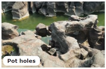
Pot hole
Due to the river action, cylindrical holes are
drilled vertically in the river bed, with varying depth and diametre. These are
called pot holes.
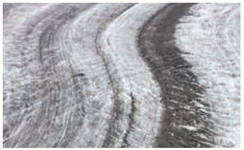
Meander
As the river loaded with debris flows slowly, it
forms sweeping loops and bends. It is referred to as meanders.
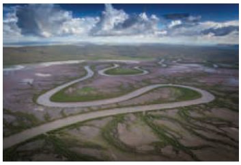
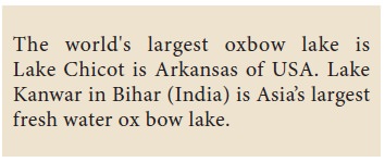
Ox bow lake
Meanders in due course of time become almost a
complete circle with narrow necks. This in turn gets abandoned and forms a
lake. This is called an Ox-bow lake.
Depositional Landforms of River
Alluvial Fan
A fan shaped deposition made by the river at the
foothills is called an alluvial plain
Flood Plain
Fine sediments are deposited on river banks when a
river floods. These sediments make the region rich and fertile. This is called
a flood plain. As the height of the river banks gets increases due to
continuous deposition of a flooded river, levees are formed.
Estuary: Estuary
is formed where the rives meets the
sea. Deposition of silt by the river is not possible here in the estuaries like
delta as if the waves keep on eroding the deposits. Ex. River Narmada and
Tapti.
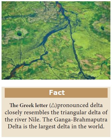
Delta
A triangular shaped low lying area formed by the
river at its mouth is called delta. Deltas have fine deposits of sediments
enriched with minerals. Eg. Cauvery Delta, Tamil Nadu.
Groundwater
Water that percolates through the pores and
fissures of rocks gets collected beneath the earth’s surface. This is normally
referred to as groundwater or
sub-surface water. The rate of
percolation depends on the nature of
the rocks.
·
The rocks that allow water to percolate are called
porous rocks or permeable rocks.
·
The rocks that does not allow water to seep through
them are called non-porous rocks or
impermeable rocks.
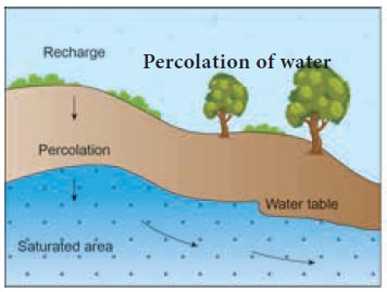
The percolated water in course of time returns back
to the surface in the form of springs, geysers, hot springs, wells, tanks,
artesian wells etc. that are useful for human activities.
As an
agent of gradation, under-ground water creates distinct landforms in limestone
regions called Karst Topog-raphy.
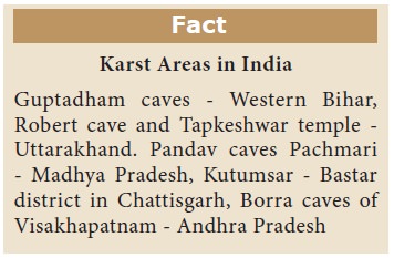
Karst Topography
Ground water is an active agent in limestone
regions. Karst topography is formed due to the dissolution of soluble rocks
such as limestone, dolomite and gypsum.
Limestone topography of Western Slovenia extends
for a distance of 480 km in length and 80 km in width which is termed as Karst
in the Slavic language. The world’s largest karst area is the Nullarbar located
on the Great Australian Coast.
Karst regions are also found in Southern France,
Spain, Mexico, Jamaica, Western Cuba, Central New Guinea, Sri Lanka and
Myanmar.
Karst topography also exhibits both erosional and
depositional features.
Erosional Landforms of Underground Water
Most of erosion takes place due to the process of
solution. When rain water mixes with carbon-di- oxide and enters into a
limestone region, it dissolves and destroys much of the limestone. As a result,
landforms such as Terra rossa, Lappies, sinkholes, swallow holes, dolines,
uvalas, poljes, caves and caverns are formed.
Terra Rossa (Italian term for Red soil)
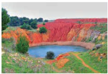
Deposition of red clay soil on the surface of the
Earth is due to the dissolution of limestone content in rocks. The redness of
the soil is due to the presence of iron oxide.
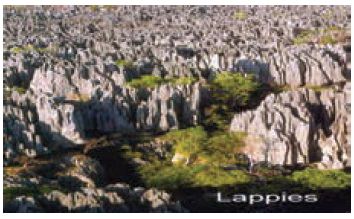
Lappies
When the joints of limestone rocks are corrugated
by groundwater, long furrows are formed and these are called LAPPIES.
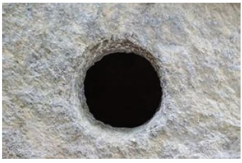
Sinkhole
A funnel shaped depressions formed due to
dissolution of limestone rock is called sinkholes. Their average depth ranges
between three and nine meters
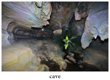
Caves and Caverns
Caves and caverns are subterranean features of
karst topography. Caves are hollows that are formed by the dissolution of
limestone rocks when carbon di oxide in air turns into carbonic acid after its
reaction with water. They vary in size and shape. Caverns are the caves with
irregular floors. Eg. Guptadham caves in Western Bihar.
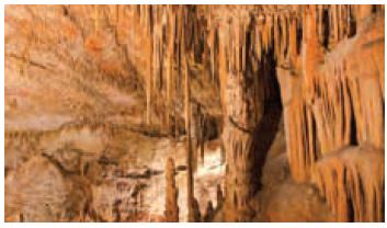
All types of deposits in the caves and caverns are
collectively called speleothems which includes travertines, tufa, dripstones.
Swallow Holes, Uvalas, Dolines, Poljis are other
erossional Features of karst regions predominant in other parts of the world.
Depositional Landforms Underground Water
It is interesting to know that a variety of
depositional features are formed on the floor, ceiling and walls of the caves
and caverns of the Karst Topography.
Stalactite, Stalagmite and Column
When the water containing dissolved calcite
gradually drips from the ceiling of the caves, water evaporates and the
remaining calcite hangs from the ceiling. Thus Stalactites are formed. When the calcite deposits rises upward like
a pillar Stalagmites are formed.
Sometimes, Stalactites and
Stalagmites meet together to form Columns
and Pillars
Glaciers:
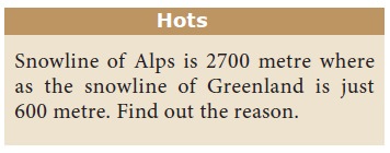
A Glacier is a large mass of ice that moves slowly
over the land, from its place of accumulation. It is also known as ‘River of
ice’. The place of accumulation is called snowfield. The height above which there is
a permanent snow cover in the higher altitude or latitude is called snowline.
Higher the latitude, lower the snowline from sea
level.
The gradual transformation of snow into granular
ice is called ‘firn’ or ‘ neve’ and finally it becomes solid glacial ice.
Movement of Glacier
The large mass of ice creates pressure at its
bottom and generates heat. Due to this, the glacier melts a little and starts
to move .The rate of movement of a glacier varies from a few centimetres to
several hundred meters a day. The movement of glaciers depends on slope, volume
of the glacier, thickness, roughness at the bottom (friction) etc., and
Temperature. Like the rivers, glaciers also carry out erosion, transportation
and deposition.
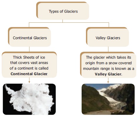
Types of Glacier
Glaciers are broadly divided into two types based
on the place of occurrence, such as Continental glacier and valley glacier.
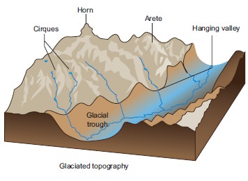
Erosional Landforms of glacier
Glaciers are powerful erosive agents. Some of the
important erosional landforms are Cirque, Aretes, Matterhorn, U-shaped valley,
Hanging valley, Fiords etc., Most of these glacial features are predominantly
seen in countries like Switzerland, Norway etc.,
Cirque
The glacier erodes the steep side walls of the
mountain and forms a bowl-shaped armchair like depression, it is termed as Cirque
Arete
Aretes are narrow ridges formed when two cirque
walls joined together back to back, and forms narrow knife like ridges.
Matterhorn
The pyramidal peaks formed when three or more
cirques meet together, are referred as Matterhorns.
U-Shaped Valley
When the glacier moves down along a river valley,
the valley further gets eroded deep and wide to form a ‘U’ shaped valley.
Hanging Valley
These are valleys eroded by tributary glacier and
that hangs over the main valley.
Fjord
Fjords are glacial valleys that are partly
submerged in the sea.
Depositional Landforms of glacier
After getting eroded, fragments of rocks and
boulders along with dirt form glacial
debris. Glacial debris gets
deposited in the low lying areas and
form depositional features like moraines, drumlins, eskers, kames and outwash
plains.
Moraine
Landforms formed by the glacial deposits of valley
or continental glaciers are termed as moraines. They are of various shapes and
sizes, like ground, terminal and lateral moraines etc
Drumlin
Drumlins are
deposits of glacial moraines that
resemble giant inverted teaspoons or half cut eggs.
Esker
Long narrow ridges composed of boulders gravel and
sand deposited by streams of melting water which run parallel to a glacier are
called eskers.
Outwash Plain
An outwash plain consists of glacial sediments
deposited by the melting ice at the terminus of a glacier. It appears as an
extensive accumulation of sand, gravel and silt.
Wind
When air blows horizontally at or near the earth’s
surface is called wind. The erosional, transportational and depositional action
of wind is predominant in arid regions. This is called as Aeolian Process.
Erosional Landforms of wind
Some of the erosional landforms of wind are
mushroom rocks, Inselbergs and yardangs.
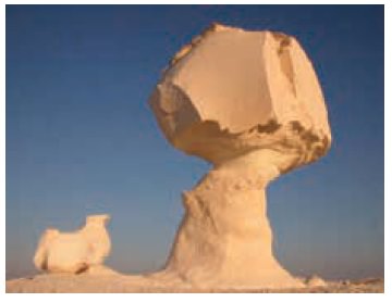
Mushroom Rock
Rocks are made up of hard and soft layers. When a
rock’s bottom is soft, the sand-laden winds blow against it and wear it down.
By the constant wearing down action of the wind, the bottom gets eroded away to
form a mushroom like structure. This is called a mushroom or pedestal rock.
Such rocks are found near Jodhpur in Rajasthan.
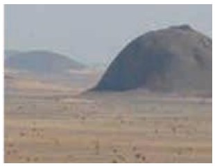
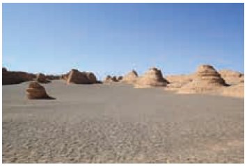
Inselberg
Inselberg is a German term which means an island
mountain. Certain hard rocks like igneous rocks are more resistant to wind
action. Such isolated residual hills rising abruptly from their surroundings
are termed as inselbergs. Eg. Uluru or Ayers Rock, Australia.
Yardang
In arid regions, certain rocks have hard and soft
layers arranged vertically. When winds blow over these rocks, the soft layers
get eroded leaving irregular crests. These are called yardangs.
Depositional Landforms of wind
Deposition occurs when the speed of wind is reduced
by the presence of obstacles like bushes, forests and rock structures. The
sediments carried by wind get deposited on both the wind ward and leeward sides
of these obstacles.
Some of the depositional landforms are sand dunes,
barchans and loess.
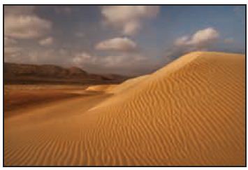
Sand Dune
In deserts, during sandstorms, wind carries loads
of sand. When the speed of wind decreases, huge amount of sand gets deposited.
These mounds or hills of sand are called sand dunes. There are different types
of sand dunes.
Barchan
Barchans are isolated, crescent shaped sand dunes.
They have gentle slopes on the windward side and steep slopes on the leeward
side.
Transverse Dunes
Transverse dunes are asymmetrical in shape. They
are formed by alternate slow and fast winds that blow from the same direction
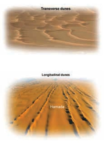
Longitudinal Dunes
Longitudinal dunes are long narrow ridges of sand,
which extend in a direction parallel to the prevailing winds. These dunes are
called Seifs in Sahara
Loess
The term loess refers to the deposits of fine silt
and porous sand over a vast region. Extensive loess deposits are found in
Northern and Western China, the Pampas of Argentina, in Ukraine and in the
Mississippi Valley of the United States.
Wave
A steady up (crest) and down (trough) movement of
surface water are called waves. Sea waves are the most powerful agents of
gradation and their erosional, transportational and depositional processes are
confined to a very narrow belt along coastal areas
Erosional Land Forms of Waves
Some of the erosional landforms of sea waves are
sea cliff, sea cave, arch, stack, beach, bar and spit and wave cut platform.
Sea Cave
Prolonged wave attack on the base of a cliff erodes
rock materials, which result in the formation of caves.
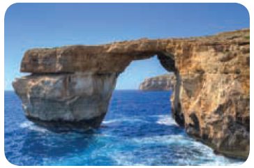
Sea Arch
When two caves approach one another from either
side of a headland and unite, they form an arch.
(Eg.) Neil Island, Andaman and Nicobar.
Sea Stack
Further erosion by waves ultimately leads to the
total collapse of the arch. The seaward portion of the headland will remain as
a pillar of rock known as stack. Eg
the Old man of Hoy in Scotland.
Sea Cliffs
Sea cliffs are steep rock faces formed when sea
waves dash against them. The rocks get eroded to form steep vertical walls.
Wave Cut Platforms
Flat surface found at the foot of sea cliffs are
called as wave cut platforms. Wave cut platform is also referred as beach,
shelf, terrace and plain.
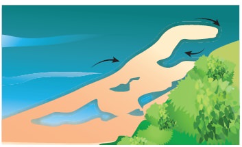
Depositional Landforms of Waves
Beach
Sand and gravel are moved and deposited by waves
along the shore to form beaches.
This is the most dominant and constructive work of the sea. (Eg.) Juhu beach
along Mumbai coast, Puri beach in Odisha and Marina beach in Chennai.
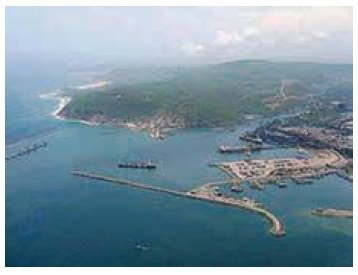
Bar
A bar is an elongated deposit of sand, shingle or
mud found in the sea, almost parallel to the shoreline.
Spit
A spit is a ridge or embankment of sediment,
attached to the land on one end and terminating in open water on the other end.
Spits are common at the mouth of estuaries. Eg. Kakinada spit
Related Topics