Geography - Geomorphic Processes | 9th Social Science : Geography : Lithosphere – I Endogenetic Processes
Chapter: 9th Social Science : Geography : Lithosphere – I Endogenetic Processes
Geomorphic Processes
Geomorphic Processes
The formation and deformation of landforms on the
surface of the Earth is a continuous activity of two broad processes i.e.
internal and external. These processes cause stress and deformation on Earth
materials and finally bring changes on the surface of the Earth. These are
referred as Geomorphic
Processes.
The forces that act from the Earth’s interior
towards the Earth’s surface are called Internal processess or Endogenetic processes. These forces build the landscape and
create topographic relief.
The forces that act on the surface of the Earth due
to natural agents like running water, glacier, wind, waves etc. are called External
processes or Exogenetic processes. These external processes tear the landscape down into
relatively low elevated plains.
Internal Processes
The internal processes generate heat and eject
materials from deep below the Earth’s crust. Internal radioactivity is the principal source of power for this process.
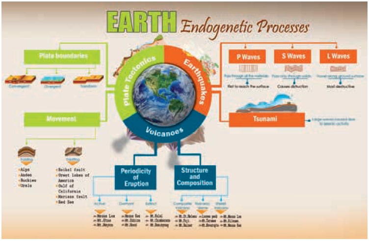
Plate Tectonics
The lithosphere is divided into a number of huge
slabs of rocks called ‘Tectonic plates.’ These tectonic plates are
divided into major and minor plates. These plates float independently over the
mantle. Collisions of these plates produce mountain ranges and other irregular
surface features, both on land and the ocean floor. This phenomenon is called ‘plate tectonics’.
The movement of tectonic plates is due to thermal energy from the mantle. Now
we have a better understanding about the plate movements and its relation to
Earthquake and volcanic activities.
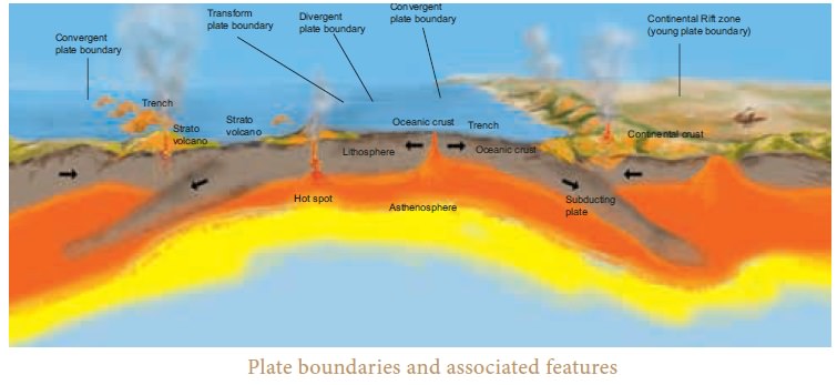
Types of Plate Boundaries
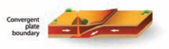
Convergent Boundary - Here the plate moves toward each
other and sometimes, a plate sinks under another. The location where the
sinking of a plate occurs is called a subduction zone.
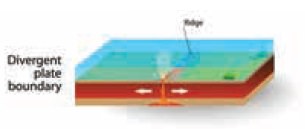
Divergent Boundary – Here the plates pull away from each
other as magma pushes up from the mantle.
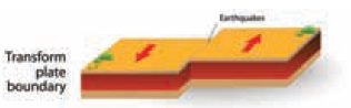
Transform Boundary – Here the plates slide horizontally
past each other.
Movements of Continental Plates
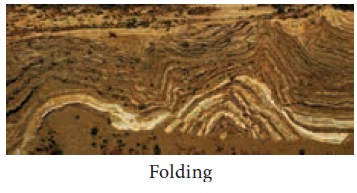
Due to lateral compressional forces, the plates are
forced to move upwards and downwards. This is called ‘Folding’.
Mountains formed by folding are called fold
mountains. the Process of folding creates lofty mountain ranges such as the
Himalayas and the Alps
The movement of plates also create stress and
tension in the rocks, causing them to stretch and crack. This is called ‘Faulting’.
The great rift valley of East Africa is a notable example for the process of
faulting. The process of folding and faulting together with volcanoes and
Earthquakes continually reshape the continents and seafloor.
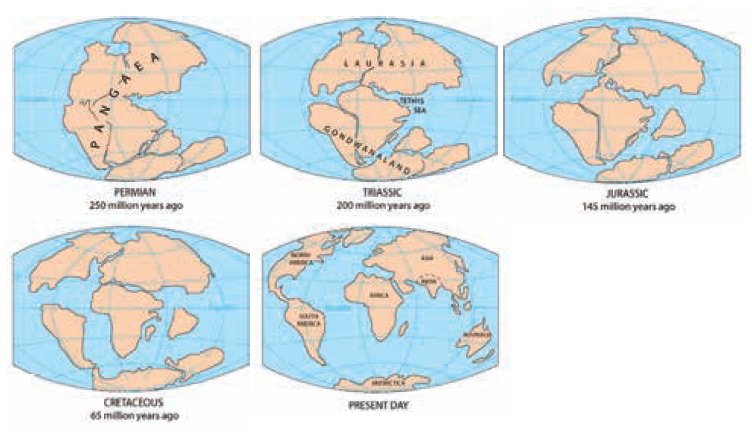
According to plate tectonics, the plates are in
constant motion with an average rate of few centimetres per year. The movement
might seem slow, but over millions of years, the plates and the continents
riding on them move a long way. For example, about 250 million years ago, the
Indian Plate was a part of the Gondwana land, which comprised of modern
Africa, Australia, Antarctica, and South America.
Approximately 140 million years ago, the Indian
plate broke away from the ancient super continent ‘Gondwana’ and began moving
north and collided with Asia. The collision with the Eurasian Plate along the
boundary between India and Nepal formed the Orogenic belt that created the
Tibetan Plateau and the mighty Himalayan Mountains.
Earthquake
Earthquakes are generally caused by the sudden vibrations in the
Earth’s crust, which spreads outward in all directions as waves from the source
of disturbance.
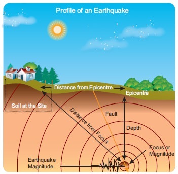
The point of origin of an Earthquake is called ‘Focus’
(Hypocenter) which generates a series of elastic waves. ‘Epicentre’ is a point on the Earth’s surface
that lies directly above the focus. The impact of the Earthquake is felt the
most at the epicentre.

Seismic Waves
Earthquakes generate seismic waves. The nature, force
and speed of these seismic waves depend on the nature of the medium through
which it passes. Accordingly, there are three major types of waves.
Primary or P-waves are the fastest of all the Earthquake
waves and the first to reach the epicentre. These waves pass through solids,
liquids and gases, either through push or pull with an average velocity of
5.3km per second to 10.6 km per second.
Secondary or S-waves travel only through solids. These
transverse waves shake the ground perpendicular to the direction in which they
propagate. The average velocity of these waves is 1Km per second to 8 km per
second.
Surface Waves (or) L -waves are similar to
P-waves but they travel primarily along the ground surface. These waves travel
comparatively slower and are the most destructive waves. The average velocity
of these waves are 1 km per second to 5 km per second.
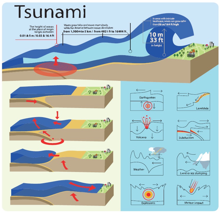
Tsunami
The word ‘Tsunami’ is a Japanese term, meaning
harbour waves. It is adopted to describe large seismically generated sea waves
caused by Earthquakes, submarine explosions and landslides. These waves travel
at a great speed (more than 500 km per hour) and the length of the waves
exceeds 600 km. These waves reach to a height of more than 15 m near the sea
shore and are capable of causing destruction along the coastal area.
The 2004 Indian Ocean Earthquake that caused
tsunami is the sixth -deadliest natural disaster which travelled at a speed of
600 km per hour with an estimated death toll of 2,80,000. The Earthquake which
occurred near Indonesia at 00.58 hours took nearly 7 hours to reach Chennai.
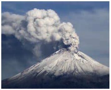
Volcanoes
A volcano is a vent or an opening on the surface of
the Earth crust, through which hot solid, liquid and gaseous materials (Magma)
erupt out to the surface from the Earth’s interior. Magma rises up and ejects
on the surface as Lava. Volcanoes are also formed when plates
move apart.
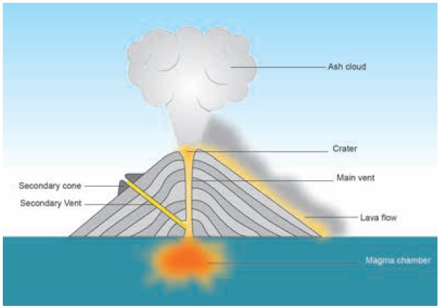
Volcanoes generally have the following major
components. They are:
·
Magma chamber - a large pool of liquid rock found
beneath the surface of the Earth
·
Vents - an opening serving as an outlet for air,
smoke, fumes, magma etc
·
Volcanic cone - a landform built by the magma
ejected from the vent in the shape of a cone.
·
Crater - a bowl shaped depression found at the top
of the volcano through which the magma flows out.
Based on the periodicity of eruptions, volcanoes are
classified into
(i) Active volcano, (ii) Dormant volcano, (iii) Extinct
volcano.
(i) Active Volcano
Active volcanoes are those which constantly eject
volcanic lava, gases and fragmented materials. (eg.) Mount St. Helens in the
United States.
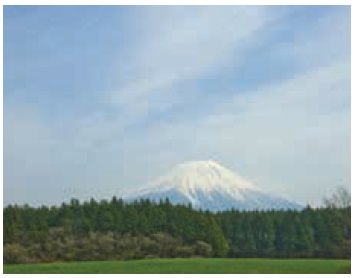
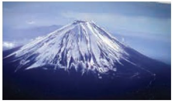
(ii)Dormant Volcano
Volcanoes that do not show any sign of volcanic
activity for a long period of time are known as dormant volcanoes. Sometimes
there may be a sudden explosion which may cause unimaginable loss to life and
property (e.g.) Mt. Fuji , Japan
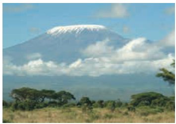
(iii)Extinct or Dead Volcano
When a volcano permanently stops its volcanic
activity, then it is called as extinct or dead volcano (e.g.) Mt. Kilimanjaro,
Tanzania
Volcanoes can also be classified based on their structure and
composition as composite
volcano, shield volcano and dome volcano
o
Composite
Volcano
Composite volcano, also known as strata volcano, is a
conical volcano built by many layers of hardened lava, pumice and volcanic ash.
These are commonly found in the Pacific Ocean Eg. Mt. Fuji, Japan
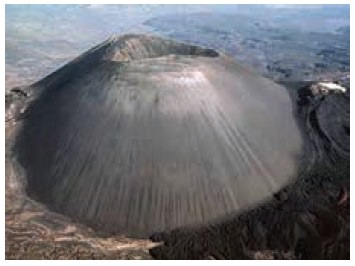
o
Volcanic
Dome
A lava dome or volcanic dome is roughly a circular
mound formed due to the slow ejection of viscous lava from a volcano. As the
lava is rich in silica with intense viscosity, it is prevented from flowing far
from its vent. e.g. Parícutin, Mexico
o
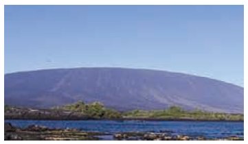
Shield
Volcano
Shield volcanoes are formed by intense viscous
lava.
These are shallow depositions with gently sloping
sides.
Hence the lava flows out in all directions to
create a shield.
E.g., Mauna Loa, Hawaii
Distribution of Earthquakes and Volcanoes
Most Earthquakes and volcanic eruptions do not
strike randomly, but occur along the plate boundaries. One such area is the
circum-Pacific Ring of Fire, where
the Pacific Plate meets many surrounding
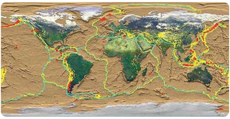
The Ring of Fire is the most seismically
and volcanically active zone in the world. The other distinctive major belts
are Mid-Oceanic Ridges and Mid-Continental Belts.
Related Topics