Geography - Field Report | 11th Geography : Chapter 13 : Field Work and Report Writing
Chapter: 11th Geography : Chapter 13 : Field Work and Report Writing
Field Report
Field
Report
Writing a report of the work carried on in the
field is a documentation of the field work. This helps in systematic reviewing
of the work by students who accomplished the task and a reference for future
field trips. Field reports must be short, clear and informative with supportive
data, maps, sketches, photographs etc.
There are a number of steps involved in report
writing. They are:
Title:
Identify the topic of investigation which is the
purpose of field work. This is the title of the work and it has to be written
in bold letters at the top of the report.
Introduction:
Every report should start with a brief introduction
to the subject under study. It should explain what part of geography it relates
to. For example if the study is about a stream, it falls under the branch of physical
geography, more specifically geomorphology - an exogenetic agent of denudation.
The time frame that was planned for the fieldwork can be elaborated. If the
field work is extending for more than one day, then a clear timetable should be
given.
Need for the Study:
The reason why the field work is undertaken can be
mentioned. This explains the need for the field work.
The Study Area:
Details of the study area are explained here –
starting with the absolute or geographical location of the study area, the
choice of the study area and the physiography of the area. Other known physical
and cultural details of the study area can be mentioned here. A copy of the
map, satellite image etc. can be incorporated here.
Methodology Used:
The methods used to carry out the field work have
to be mentioned here. The method of information collection varies according to
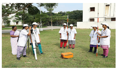
the type of study. It could be through observation, investigation,
measurements; data collection from primary and secondary sources; field
sketches, audio-video recording and photographs and GNSS surveys.
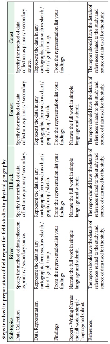
Data Analysis:
The data collected through field work should be
presented in a simple way for easy analysis. The method of representation of
data should be according to the method of data collected. Example: 1. If
observation method is used in data collection then the data can be represented
as photographs or field sketches. 2. If data is collected through surveys, it
can be represented as a plan or map. 3. Data collected from secondary sources
can be presented as tables, graphs, diagrams or charts. 4. Data collected
through GNSS surveys can be mapped.
The data represented in various forms have to be
neatly labeled and indexed for easy identification and understanding. The
photographs, diagrams, tables, maps etc. prepared during post field work have
to be arranged in a sequential order so that they can provide an answer to the
purpose of study and add more meaning and value to the report of work done in
the field.
Conclusion:
The conclusion gives the gist of the field work –
the aim, the results or findings and how it relates to existing knowledge and
the addition of new knowledge through this field work. The conclusion has to
present how the fieldwork has enhanced the theoretical knowledge gained in the
class.
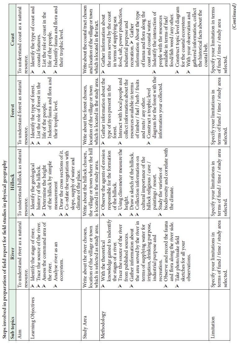
The table below gives a few steps in the
preparation of field report for a few case studies under physical geography.
Exercises
1.
Measure
your school’s play ground and draw a plan of the same.
2.
Arrange
a field trip to a River line area study the land, direction of flow of water,
trees and other plants in the area. Make a field sketch and prepare a short
report.
3.
Measure
the daily temperature at 11.00 am and 4.00 pm and find the monthly average of
maximum and minimum temperature.
4.
Plan a
field visit to a nearby hilly area study the slope, gradient, trees and other
plants in that area. Prepare a field sketch of the same and write a short
report.
Related Topics