Reconstruction of Post-colonial India | History - Consequences of Partition | 12th History : Chapter 8 : Reconstruction of Post-colonial India
Chapter: 12th History : Chapter 8 : Reconstruction of Post-colonial India
Consequences of Partition
Consequences of Partition
The
challenges before free India included grappling with the consequences of
partition, planning the economy and reforming the education system (which will
be dealt with in the following lesson), making a Constitution that reflected
the aspirations kindled by the freedom struggle, merger of the Princely states
(more than 500 in number and of different sizes), and resolving the diversity
on the basis of languages spoken by the people with the needs of a
nation-state. Further, a foreign policy that was in tune with the ideals of
democracy, sovereignty and fraternity had to be formulated.
The
partition of India on HinduŌĆōMuslim lines was put forth as a demand by the
Muslim League in vague terms ever since its Lahore session (March 1940). But
its architecture and execution began only with Lord MountbattenŌĆÖs announcement
of his plan on June 3, 1947 and advancing the date of transfer of power to
August 15, 1947. The time left between the two dates was a mere 72 days.
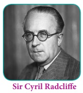
Sir Cyril
Radcliffe, a lawyer by training with no exposure to India and its reality, was
sent from London to re-draw the map of India. Its execution was left to the
dominion governments of India and Pakistan after August 15, 1947.

Radcliffe
arrived in India on July 8, 1947.He was given charge of presiding over two Boundary
Commissions: one for the Punjab and the other for Bengal.Two judges from the Muslim
community and two from the Hindu community were included. The commissions were
left with five weeks to identify villages as Hindu or Muslim majority on the
basis of the 1941 census. It is widely accepted that the census of 1941,
conducted in the midst of the World War II led to faulty results everywhere.
The
commissions were also constrained by factors such as contiguity of villages and
by demands of the Sikh community that villages in West Punjab where their
shrines were located be taken into India irrespective of the population of
Sikhs in those villages. The two commissions submitted the report on August 9,
1947. MountbattenŌĆÖs dispensation, meanwhile, decided to postpone the execution
of the boundaries to a date after power was transferred to the two dominions.
The contours of the two dominions ŌĆō India and Pakistan ŌĆō were drawn in the
scheme on August 14/15, 1947 insofar as the administration was concerned; the people,
however, were not informed about the new map when they celebrated independence
day on August 14/15, 1947.
RadcliffeŌĆÖs
award contained all kinds of anomalies. The provincial assembly in Punjab had
resolved that West Punjab would go to Pakistan. The other provinces, which were
geographically contiguous with Pakistan such as Sind, Baluchistan and the
North-West Frontier Provinces followed this. Similarly, the Bengal Assembly,
resolved that the eastern parts of the province were to constitute Pakistan on
this side.
The award
Radcliffe presented, on August 9, 1947, marked 62,000 square miles of land that
was hitherto part of the Punjab to Pakistan. The total population (based on the
1941 census) of this region was 15,800,000 people of whom 11,850,000 were Muslims.
Almost a quarter of the population in this territory ŌĆō West Punjab ŌĆō were
non-Muslims; and the Mountbatten Plan as executed by Sir Radcliffe meant they
continued to live as minorities in Pakistan. Similarly, East Punjab that was to
be part of India was demarcated to consist of 37,000 square miles of territory
with a population of 12,600,000. Of this, 4,375,000 were Muslims. In other
words, more than a third of the population in east Punjab would be Muslims.
The
demographic composition of the Indian and Pakistani parts of Bengal was no less
complicated. West Bengal that remained part of India accounted for an area of
28,000 square miles with a population of 21,200,00 out of which 5,30,000 were
Muslims; in other words, Muslims constituted a quarter of the population of the
Indian part of the former Bengal province. Sir RadcliffeŌĆÖs commission marked
49,400 square miles of territory from former Bengal with 39,100,000 people for
Pakistan. The Muslim population there, according to the 1941 census, was 27,700,000.
In other words, 29 per cent of the population were Hindus. East Pakistan (which
became Bangladesh in December 1971) was constituted by putting together the
eastern part of divided Bengal, Sylhet district of Assam, the district of
Khulna in the region and also the Chittagong Hill tracts. Such districts of
Bengal as Murshidabad, Malda and Nadia which had a substantially large Muslim
population were left to remain in India. The exercise was one without a method.
The
re-drawn map of India was left with the two independent governments by the
colonial rulers. It was left to the independent governments of India and
Pakistan to fix the exact boundaries. However, the understanding was that the
religious minorities in both the nations ŌĆō the Hindus in West and East Pakistan
and the Muslims in India, in East Punjab and West Bengal as well as in United
Provinces and elsewhere ŌĆō would continue to live as minorities but as citizens
in their nations.
After the
partition, there were as many as 42 million Muslims in India and 20 million
non-Muslims (Hindus, Sindhis and Sikhs) in Pakistan. The vivisection of India,
taking place as it did in the middle of heightened Hindu-Muslim violence, had
rendered a smooth transition impossible. Despite the conspicuous exhibition of
HinduŌĆōMuslim unity during the RIN mutiny and the INA trials (see previous
lesson), the polity now resembled a volcano. Communal riots had become normal
in many parts of India, and were most pronounced in the Punjab and Bengal.
Minorities on both sides of the divide lived in fear and insecurity even as the
two nations were born. That Gandhi, who led the struggle for freedom from the
front and whom the colonial rulers found impossible to ignore, stayed far away
from New Delhi and observed a fast on August 15, 1947, was symbolic. The
partition brought about a system in place where the minorities on either side
were beginning to think of relocating to the other side due to fear and
insecurity.
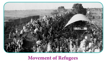
As
violence spread, police remained mute spectators. This triggered more migration
of the minorities from both nations. In the four months between August and
November 1947, as many as four-and-a-half million people left West Pakistan to
India, reaching towns in East Punjab or Delhi. Meanwhile, five-and-a-half
million Muslims left their homes in India (East Punjab, United Provinces and
Delhi) to live in Pakistan. A large number of those who left their homes on
either side of the newly marked border thought they would return after things
normalised; but that was not to be. Similar migration happened between either
sides of the new border in Bengal too.
Partition
Unbiased at least he was when he arrived on his mission,
Having never set eyes on the land he was called to partition
Between two peoples fanatically at odds,
With their different diets and incompatible gods.
ŌĆśTime,ŌĆÖ they had briefed him in London, ŌĆśis short. It's too late
For mutual reconciliation or rational debate:
The only solution now lies in separation.
The Viceroy thinks, as you will see from his letter,
That the less you are seen in his company the better,
So we've arranged to provide you with other accommodation.
We can give you four judges, two Moslem and two Hindu,
To consult with, but the final decision must rest with you.ŌĆÖ
Shut up in a lonely mansion, with police night and day
Patrolling the gardens to keep the assassins away,
He got down to work, to the task of settling the fate Of
millions.
The maps at his disposal were out of date
And the Census Returns almost certainly incorrect,
But there was no time to check them, no time to inspect
Contested areas.
The weather was frightfully hot,
And a bout of dysentery kept him constantly on the trot,
But in seven weeks it was done, the frontiers decided,
A continent for better or worse divided.
The next day he sailed for England, where he could quickly
forget
The case, as a good lawyer must. Return he would not,
Afraid, as he told his Club, that he might get shot.
Historian Gyanendra Pandey records 500,000 non-Muslim (Hindus
and Sikhs) refugees flowing into the Punjab and Delhi in 1947-48. Pandey also
records that several thousand Muslims were forced out of their homes in Delhi
and nearby places by violent mobs to seek asylum in camps set up around the Red
Fort and the Purana Quila. Refugee camps were set up but they had hardly any
sanitation and water supply.
In both
countries property left behind by the fleeing families were up for grabs. The
long line of refugees walking crossing the borders was called ŌĆśkafilaŌĆÖ. The
refugees on the march were targets for gangs belonging to the ŌĆśotherŌĆÖ community
to wreak vengeance. Trains from either side of the new border in the Punjab
were targeted by killer mobs and many of those reached their destination with
piles of dead bodies. The violence was of such a scale that those killed the numbers
of remains mere estimates. The number ranges between 200,000 to 500,000 people
dead and 15 million people displaced.

Even as
late as in April 1950, the political leadership of the two nations wished and
hoped to restore normality and the return of those who left their homes on
either side. On April 8, 1950, Nehru and Liaquat Ali Khan signed the Delhi
pact, with a view to restoring confidence among the minorities on both sides.
This, however, failed to change the ground reality. Even while the pact was
signed the Government of India was also working on measures to rehabilitate
those who had left West Punjab to the East and to Delhi and render them
vocational skills and training. The wounds caused by the partition violence
hardly healed even after decades. Scores of literary works stand testimony to
the trauma of partition.
The
partition posed a bigger challenge before Nehru and the Constituent Assembly,
now engaged with drafting the founding and the fundamental law of the nation:
to draft a constitution that is secular, democratic and republican as against
PakistanŌĆÖs decision to become an Islamic Republic.
Related Topics