Weather Maps | Geography - Weather Symbols | 11th Geography : Chapter 12 : Weather Maps
Chapter: 11th Geography : Chapter 12 : Weather Maps
Weather Symbols
Symbols are the pictorial representation of the various elements.
Weather
Symbols
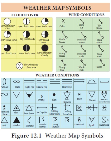
Symbols are the pictorial
representation of the various elements. On a weather map, weather elements are
represented using symbols. Weather codes are used in weather charts as
meteorological symbols. Weather symbols are created and standardized by the
World Meteorological organization and also by Natural Weather Bureaus.
Knowledge of weather symbols is prime for weather map interpretation and
weather forecasting. Weather symbols are listed below for precipitation, wind
direction, cloud cover and sea conditions. Weather symbols depicted in weather
charts help in weather forecasting.
Tags : Weather Maps | Geography , 11th Geography : Chapter 12 : Weather Maps
Study Material, Lecturing Notes, Assignment, Reference, Wiki description explanation, brief detail
11th Geography : Chapter 12 : Weather Maps : Weather Symbols | Weather Maps | Geography
Related Topics
11th Geography : Chapter 12 : Weather Maps