Atmosphere | Geography - Temperature and Heat Budget | 11th Geography : Chapter 6 : Atmosphere
Chapter: 11th Geography : Chapter 6 : Atmosphere
Temperature and Heat Budget
Temperature
and Heat Budget
Air temperature of a particular place
denotes the degree of hotness or coldness of air at a given place. It is
measured in Celsius. Let us understand how the earth is heated. The surface of
the earth is heated by the sun’s rays in the form of short wave radiation. The
heat received by the earth is called ‘Solar Radiation’ or ‘Insolation’. Heating
of atmosphere is an indirect process. The processes are:
a. Terrestrial radiation
The solar radiation reflected by the
earth’s surface is called ‘Terrestrial radiation’. Terrestrial radiation
supplies more heat energy to the atmosphere due to its long wave length.
b. Conduction
The heat energy from the earth’s
surface is transferred to the lower atmosphere which is directly in contact
with the surface by the process of conduction.
c. Convection and advection
The movement of air molecules in
vertical and horizontal direction is called as ‘convection and advection’
respectively. This movement carries heat energy to the various parts of the
earth and at different altitudes.
Heat budget
The heat energy reflected, absorbed
and radiated back into the space equals the energy received by the earth.
Incoming radiation and the outgoing radiation pass through the atmosphere. The
earth maintains its optimum temperature.
When 100% solar radiation reaches the
earth’s atmosphere, 35% is reflected back to space by clouds, water bodies and
ice covered areas. This heat does not heat either the earth or atmosphere.
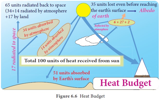
Of the remaining 65% of heat, 14% are
absorbed by the atmosphere and 51% are absorbed by the earth’s surface (34% of
direct solar radiation and 17% from scattered radiation). 51% received by the
earth are radiated back to the space directly as terrestrial radiation (Figure
6.6).
In total, 17% are radiated to space directly and 48% are absorbed by the atmosphere ( 14% from insolation and 34% from terrestrial radiation) are radiated back to space gradually. Therefore, 65% heat received from the sun is balanced by the 65% radiated by the earth.
This balance between the incoming and the outgoing heat energy is called the global
heat energy balance. Distribution of Temperature Distribution of temperature varies
both horizontally and vertically. Let us study it under
a.
Horizontal Distribution of Temperature
b.
Vertical Distribution of Temperature
A) Horizontal Distribution of Temperature
Distribution of temperature across
the latitudes over the surface of the earth is called horizontal distribution
of temperature. On maps, the horizontal distribution of temperature is commonly
shown by isotherms. Isotherms are line connecting points that have an equal
temperature at mean sea level.
Factors Affecting the Horizontal Distribution of Temperature
The horizontal distribution of
temperature on the earth’s surface varies from place to place. Following are
the factors affecting the horizontal distribution of temperature of the earth:
a.
Latitude: The angle formed by the solar radiation to the ground is called ‘angle of
incidence’. The solar radiation passes vertically along the equator. The angle
of incidence decreases from equator towards the poles. The area heated by the
solar radiation increases towards the poles and therefore, temperature
decreases from the equator to the poles.
b.
Distribution of land and water: Land is heated and cooled at a faster rate due the
conduction process whereas water is heated and cooled at slower rate due to
convection process. Water takes 2.5 times of heat energy to heat a unit area
compared to land. Thus, the land will have higher temperature than the water in
summer and vice versa during the winter. So more land mass in northern
hemisphere (15.28C) leads to higher average temperature than the southern
hemisphere (13.38C).
c.
Ocean currents: Warm ocean currents carry warm water from the tropical region
towards the poles and increase the temperature while cold ocean currents carry
cold water from Polar Regions and reduce the temperature along the coasts.
d.
Prevailing winds: Warm winds like trade wind and westerly, that carry higher heat
energy, increase the temperature while cold polar easterlies carry lower heat
energy from polar region reduces the temperature.
e.
Cloudiness: The cloudy sky obstructs the solar radiation from the sun to earth and
reduces the temperature. But the clear sky during the day allows more solar radiation
to reach the earth’s surface and increases the temperature. Meanwhile clear sky
at night allows more terrestrial radiation to escape. For example, the tropical
hot deserts experience higher temperature at day and lower temperature at
night.
f.
Nature of the surface: The reflection from surface varies based on the nature of land
cover. The more reflection from the snow surface leads to low temperature
accumulation. But the dense forest, which reflects less heat energy and absorbs
more heat energy, leads to higher temperature.
g.
Mountain barriers: If a wind or air mass blows towards the mountain, it influences the
distribution of temperature on either side of the mountain.
For example, polar easterlies and
blizzards are obstructed by Himalayas in Asia and Alps in Europe respectively.
This leads to lower temperature in the northern slopes and higher temperature
in the southern slopes of the respective mountains.
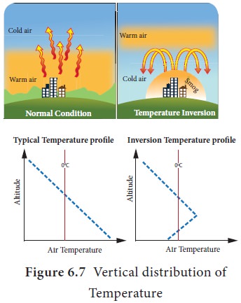
Factors Affecting the Vertical Distribution of Temperature
We all know that the temperature
decreases with increasing altitude from the surface of the earth. The vertical
decrease in temperature of troposphere is called as ‘Normal Lapse Rate’ or
‘vertical temperature (Figure 6.7) gradient’ at which the temperature reduces
at the rate of 6.5 8C per 1000 meter of ascent. This is influenced by the
following factors:
a. Amount of terrestrial radiation
reaching the altitude and
b. Density of air to absorb the heat
energy at higher altitude.
As both the above said factors
decrease with altitude, the temperature also decreases (Figure 6.5).
Student
Activity
If the temperature of Chennai (7 m) is 348C, calculate the temperature
of Kodaikanal (2133m) using normal lapse rate.
Inversion of Temperature
The condition at which the temperature
increases with altitude is called as ‘inversion of temperature’. In this
condition, warm air lies over cold air.
The conditions for inversion of
temperature are:
a. Long winter nights: The bottom
layer of the atmosphere in contact with the ground is cooled and the upper
layer remains relatively warm.
b. Cloudless sky: The higher amount of terrestrial radiation reaches the higher altitude which leads to lower temperature at low level due to clear sky.
c. Dry air near the surface: the dry air absorbs less terrestrial radiation and allows them to escape into space.
d. Snow covered ground: During night, due to terrestrial radiation and higher albedo, most of the heat is lost to the atmosphere and the surface is cooled.
e. Formation of fronts: the movement of warm air over the cold air during the formation of the various fronts leads to inversion condition.
f. Mountain wind: The subsidence of cold mountain wind at the early morning leads to the displacement of warm air from the valley to higher altitude. This type of inversion is called as ‘valley inversion’.
Measurements of Temperature
Heat Zones of the World
The earth has been divided into three heat zones
according the amount of insolation received. These are the Torrid Zone, the
Temperate zone and the Frigid Zone.
Torrid
Zone ( 23 ½ °N to 23 ½ °S)
The zone lying between the Tropic of cancer and
Tropic of Capricorn is called ‘Torrid zone’ (Figure 6.8). The sun’s rays are vertical
throughout the year and it receives maximum insolation. Thus, this is the
hottest zone.
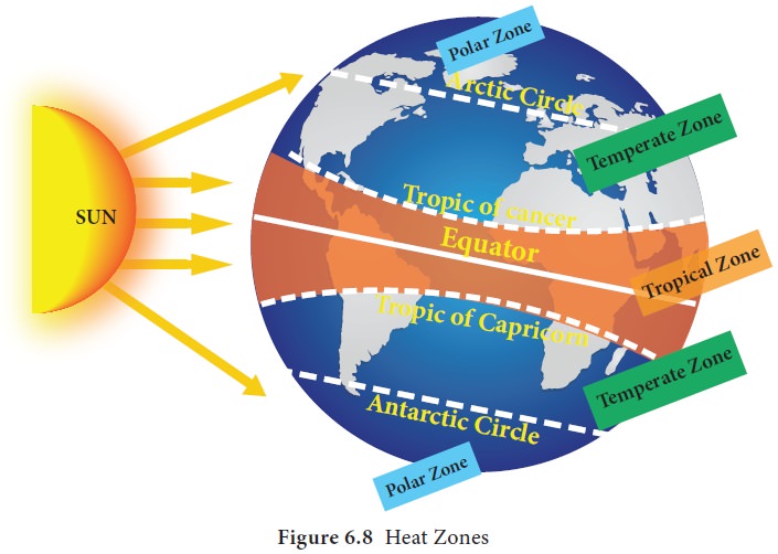
Temperate
Zone (23 ½ °N to 66 ½ °N and 23 ½ °S to 66 ½ °S)
The temperate zone lies between the Tropic of
Cancer and Arctic Circle in the northern hemisphere and the Tropic of Capricorn
and Antarctic circle in the southern hemisphere. This region never experiences
over head sun light but experiences longer days and shorter nights during
summer and vice versa during winter. This region experiences moderate temperature
and is therefore called as ‘Temperate
zone’.
Polar
Zone (Frigid Zone – 66 ½ °N to 90°N and 66 ½ °S to 90°S )
The region between North pole and Arctic Circle in
the northern hemisphere and South pole and Antarctic Circle in the southern
hemisphere is called ‘Polar Zone’. This region always receives more oblique
rays of the sun and so the temperature is very low. It is the coldest zone.
This region experiences 24 hours of day and night during peak summer and winter
respectively.
From the above discussion, it is clear that the
energy for the earth is from the sun.
Green
House Effect: As seen in the heat budget, the longer wavelengths
are absorbed by greenhouse gases in the atmosphere, increases the temperature
of atmosphere. These greenhouse gases act like a green house and retains some
of the heat energy would otherwise be lost to space. The retaining of heat
energy by the atmosphere is called the ‘greenhouse effect’.
Global Warming
Global warming is observed in a century scale. The temperature increase over theyearshas been due to the green house gas concentration such as carbon dioxide (CO2), water vapour, methane and ozone. Greenhouse gases are those gases that contribute to the greenhouse effect. The largest contributing source of greenhouse gas is the burning of fossil fuels leading to the emission of carbon dioxide from industries, automobiles and domestic.
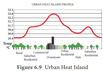
Urban Heat Island (UHI)
An urban heat island is an urban area or
metropolitan area that is significantly warmer than its surrounding rural area
due to high concentration of high rise concrete buildings, metal roads, sparse
vegetation cover and less exposure of soil. These factors cause urban regions
to become warmer than their rural surroundings, forming an “island” of higher
temperatures (Figure. 6.9).
Ways to reduce the impact of urban heat island:
a.
Increase
shade around your home: Planting trees and other vegetation, provides shade and
cooling effect through evapotranspiration and it lowers the surface and air
temperature.
b.
Install
green and cool roofs.
c.
Use
energy-efficient appliances and equipments.
d.
Shift
all industries away from the urban area.
e. Reduce emission from automobiles.
Related Topics