Geography - Scale | 11th Geography : Chapter 9 : Maps and Scale
Chapter: 11th Geography : Chapter 9 : Maps and Scale
Scale
Scale
The scale is defined as the ratio
between the distance of two points on the map and their corresponding distance
on the ground. The scale is an essential element in all types of maps. The
scale of the map permits the user to convert distance on the map to distance on
the ground.
A map scale provides the relationship
between the map and the whole or a part of the earth’s surface shown on it. We
can also express this relationship as a ratio of distances between two points
on the map and their corresponding distance on the ground. The scale can be
represented as a fraction where the numerator refers to map distance and the
denominator refers to ground distance.
There are at least three ways of
which representing scale. They are:
1.
Statement Scale
2.
Representative Fraction (R. F.)
3.
Graphical or Bar Scale
1. Statement Scale
The scale of a map may be indicated
in the form of a written statement. For example, if on a map a written
statement appears as stating 1 cm represents 10 km, it means that on that map a
distance of 1 cm is representing 10 km of the corresponding distance on the
ground.1 inch equals 16 miles. This example tells us that 1 inch on the map
represents 16 miles on the ground. This is the easiest scale to understand
because it generally uses familiar units.
Example : 1 centimetre 5 10 kilometres
Simple statement has the following
characteristics :
•
If the numerator is in centimeters, then the denominator is in metres
and kilometres.
•
If the numerator is in inch, then the denominator is in miles.
2. Representative fraction (RF)
It shows the relationship between the
map distance and the corresponding ground distance in the same units of length.
R. F. is generally shown as a fraction. For example, a fraction of 1 : 40,000
shows that one unit of length on the map represents 40,000 of the same units on
the ground i.e; 1 cm or 1 inch on the map represents 40,000 cm and 40,000
inches, respectively on the ground.
RF is represented as 1/40,000 or
1:40,000
3. Graphic or bar scale
In this type of scale the map
distances and the corresponding ground distances are marked using a line bar
with primary and secondary divisions on it. However, unlike the statement of
the scale method, the graphical scale stands valid even when the map is reduced
or enlarged. This is the unique advantage of the graphical method of
representing scale.
Example:
Example
Statement of Scale into R. F.
1. Convert the given Statement of
Scale of 1 inch represents 5 miles into R. F. Solution
The given Statement of Scale may be
converted into R. F. using the following steps.
1 inch represents 5 miles or 1 inch
represents 5 3 63,360 inches (1 mile 5 63,360 inches) or 1 inch represents
316,800 inches
Answer
R. F. 1 : 316,800 or 1/316800
R. F. into Statement of Scale
2. Convert R. F of 1 : 200,000 into
Statement of Scale (In Metric System) Solution
The given R. F. of 1 : 200,000 may be
converted into Statement of Scale using the following steps :
1 : 200,000 means that 1 unit on the
map represents 200,000 units on the ground.
or 1 cm represents 200,000 /100,000
(1 km 5 100,000 cm)
or 1 cm represents 2.0 km
Answer
1 cm represents 2 km
3. Convert the given Statement of
Scale into Representative Fraction (R. F.).
5 cm represents 10 km
2 inches represents 4 miles
1 cm represents 100 metres
5 cm represents 10 km
Step 1:
convert into same units of
measurement
(1 Km 5 100000 cm)
Step 2:
10 km 5 1000000 cm Therefore
5 cm: 1000000 cm
Step 3:
simplify the ratio
1: 1000000/5
Answer
: R.F. 5 1:
200000 or 1/200000
b. 2 inches represents 4 miles
Step 1:
convert into same units of
measurement
(1 mile 2 63,360 inches)
Step 2:
4 miles 5 63,360 3 4 5 253440
Therefore 2 inches: 253440 inches
Step 3:
simplify the ratio
1: 253440/2 5 126720
Answer
: R.F. 5 1:
126720 or 1/126720
c) 1 cm represents 100 metres
Step 1:
convert into same units of
measurement
(1m 5 100 cm)
Step 2:
100 m 5 10000 cm Therefore
1 cm: 10000 cm
Answer
: R.F. 5 1:
10000 or 1/10000
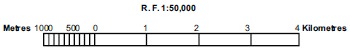
Construction of the Graphical/Bar Scale
1. Construct a graphical scale for an
R.F. 1 : 50,000 and read the distances in kilometre and metre.
(NOTE: By convention, a length of
nearly 15 cm is taken to draw a graphical scale.)
Calculations
To get the length of line for the
graphical scale, these steps may be followed:
R.F. 51 : 50,000 means that 1 unit of
the map represents 50,000 units on the ground or 1 cm represents 50,000 cm or
0.5 Km (1 Km 5 100000 cm). Therefore, 10 cm represents 5.0 km
Construction
The graphical scale may be
constructed by following these steps:
Draw a straight line of 10 cm and
divide it into 5 equal parts these are the primary division. Mark the first
division as 0. Assign the value of 1 km for the four divisions starting from 0.
Therefore the primary scale has 4 divisions and is 4 km long.
Divide the extreme left side division
into 10 equal parts and mark each division by a value of 100 metres, beginning
from 0. This is the secondary scale representing 1000 mts.
Exercise
1. Convert the statement into RF.
a.
1 cm 5 10 km
b.
1 cm 5 5 km
c.
1 cm 51 km
d.
1 cm 5 50km
e.
1 cm 5100 km
2. Convert the RF into statement:
a.
1: 100000
b.
1: 50000
c.
1: 250000
d.
1: 5000000
e.
1: 30000
3. Construct a graphical scale for
the following:
a.
1 cm 5 10 km
b.
1 cm 5 5 km
c.
1 cm 51 km
d.
1 cm 5 50km
e.
1 cm 5100 km
Related Topics