Chapter: Civil : Water Resources and Irrigation Engineering : Diversion and Impounding Structures
River Training
RIVER TRAINING
Introduction
River training is an ageold practice resulting in incessant development and application of human ingenuity to correct vagaries of the rivers. It requires deep and precise study of river mechanism and behavior discussed heretofore. River training has assumed considerable significance in India due to huge annual recurring damage caused by the floods; 80 per cent of which accounts for loss of crops. River training, in its broad aspects, covers all engineering works constructed on a river to guide and confine the flow to the river channel, and to control and regulate the river bed configuration for effective and safe movement of floods and river sediments. In essence, river training envisages training and stabilizing a river within a suitable waterway and along a certain alignment for a variety of purposes. River training works involve large outlays and it is essential to select the type of the training work and materials of construction so as to make optimum utilization of funds, and effective and economical utilization of the available construction materials.
Objectives of River Training Works
The various objectives of river training are (i) To guide the axis of flow at ordinary and low stages and safe passage of floods without overtopping the banks. (ii) To protect the banks from erosion and generally improve their alignment by stabilizing the river channel, (iii) To train the river flow along a safe course, thereby avoiding damage by flooding or erosion of valuable lands, habitation, crops, factories, etc., (iv) To prevent outflanking of a bridge, barrage or weir by directing the flow in a defined stretch of the river, (v) To prevent river from changing its course, (vi) To confine a river channel which has become too wide by swinging from side to side and to reclaim the land from river bed, (vii) To check certain devastations like that of flash torrents, (viii) To trap bed load in areas of superfluous width, (ix) To transport efficiently bed load and suspended sediment load, (x) To provide sufficient depth of flow for safe navigation, (xi) To establish channel boundaries where braiding has created too wide a section divided into small channels separated by island, and (xiii) To correct disorderly banks or flow conditions.
CLASSIFICATION OF RIVER TRAINING WORKS
1. Classification Based on Purpose
1. High Water Training: River training aimed at flood protection is called high water training or training for discharge. It envisages provision of adequate waterway for safe passage of maximum flood by proper location, alignment and height of embankments for a given floow discharge without tending to change river bed conditions.
2. Low Water Training: Also termed as training for depth. It envisages to provide adequate water depths during low water periods in the river channel for navigation by concentrating flow in a desired channel and closing other channels by the method of bandalling i.e., contracting the width of the river cannel with the help of groynes, etc.
3. Mean Water Training: Also termed as training for sediment. It is by far the most important type of river training. It envisages rectification of the river bed configuration and efficient movement of suspended and bed load for maintaining the channel in good condition. The maximum aggrading capacity of a stream occurs in the vicinity of mean water or dominant flood discharge, and as such tends to change the river bed in accordance with that stage of bed flow. Mean water training includes river training for efficient sand exclusion from canals by correcting adverse river curvature to locate the canal off take.
2. Classification Based on Structure Alignment
1. Longitudinal structure: These aim at guiding the axis of flow at ordinary and low stages, protecting the banks from erosion, generally to improve their alignment, trapping bed load in the areas of superfluous width, and establishing channel boundaries where braiding has created too wide a section divided into small channels separated by islands. Longitudinal training works are preferred to projecting training works in rivers carrying small bed loads, and with narrow channels having steep sloped and swift currents. In rivers with unstable bed conditions, longitudinal works are susceptible to damage by undermining.
2. Projecting training works. Projecting training works aim to protect the bank from which they project into the river by deflecting the current away from the bank. They are more suitable in rivers with unstable bed conditions. Cross connecting dikes to the bank at intervals add strength to withstand flood action and promote sedimentation in the closedoff channel space.
PRINCIPLES OF RIVER TRAINING
Two approximate theories, the theory of tractive force for bed load, and regime theory for suspended load are available for application to problems of river training.
1. Tractive Force Theory
Tractive force approach is essentially lan tractive force for the incipient conditions of bed movement. The alluvial rivers carry sediments in suspension as well as bed load. The capacity of river channel is designed to cater for the discharge and sediment load by the following formula:
Qs =0.17/m3/4 r2 BR2 S2
Also Q=1/n BR5/ 3 S1/ 2 (Manning's formula)
![]() Qs = silt bed charge (cumecs), m = dia. Of sand (mm), r = specific weight,
Qs = silt bed charge (cumecs), m = dia. Of sand (mm), r = specific weight,
2. Regime Flow Theory
In incoherent alluvium, Lacey’s regime theo dimensions, although there is a marked divergence when applied to large rivers due to omission
of an important parameter, viz., quantity of silt in suspension are important where silt charge in the flow predominates.
METHODS OF RIVER TRAINING
Planning and design of river training works is done by empirical methods and on the intuitive judgments of engineers. The method of river training applicable depends mainly on the type of river and sediment load, as under. Under certain cases, where river is very unstable, training is almost impossible and the situation has to be met as it arises.
1. Stable rivers:
Stable rivers are characterized by stability of alignment, slopes and regime as they mould their beds to carry into sea almost all the silt brought down by them. They are amenable to river training to attain ultimate stability with the aid of training works such as spurs and guide banks.
2. Aggrading rives:
Aggrading rivers have inherent instability and are not equally amenable to river training. Stability cannot be imposed, e.g., bank protection works may either be destroyed by severe erosion or get bur.
3. Degrading rivers:
Degrading rivers too have inherent instability and not easily amenable to river training. Stability cannot be imposed, e.g. training works may be destroyed by undermining due to bed scour. Gradient control by constructing dams and weirs is a prerequisite to attempting any other modifications in the river. Local training works may be possible if their repercussions on river regime upstream and downstream are not drastic.
Model studies for details refer ‚Hydrologyandwater resources enginee is a very useful tool in the design of river training works. Generally mobile bed models are constructed. When a river has a predominant bed load movement, its simulation, both qualitatively and quantitatively, is possible is possible in the model. However, similitude of the suspended load in models is not possible. The conformity between hydraulic models and prototype is subject to limitations.
PLANNING FOR RIVER TRAINING MEASURES
The training measures are planned with due regard to the limitations imposed by the type of river. The various steps involved are as follows:
1. Alignment. Alignment of training work is generally based on the layout and number of training structures involved. A better way to arrive at radius of curve is to study to photographs of alignment of a stable stretch of river on a similar grade and soil conditions in the vicinity of the erosion site and from this stable section measure the radius of curves. An attempt is the made to develop an alignment with curves of similar radius to those measured. Once the proposed alignment is decided, the methods of control to stabiles the channel to its alignment are considered.
2. Cross section. The cross section is that built by the river itself, i.e., when the channel is uniform and does not show signs of accretion of retrogression. The proposed section is either by river contraction or by river diversion and is compared with the normal cross section with regard to gauge and discharge relation, velocity of flow, and total sediment runoff. The section is modified by successive analysis to bring it in line with the normal corss section as far as possible.
TYPES OF RIVER TRAINING WORKS
River training works are of the types discussed as under:
1. Guide Banks
Also called Bell’s bund. It is defined as the site of a barrage, weir, bridge, ect. To guide the river flow through the confined waterway without causing damage to the structure and its approaches. They are provided in the direction of flow, both upstream and downstream of the barrage of one or both flanks depending or requirement. The guide banks are usually provided in pairs, symmetrical in plan and may either
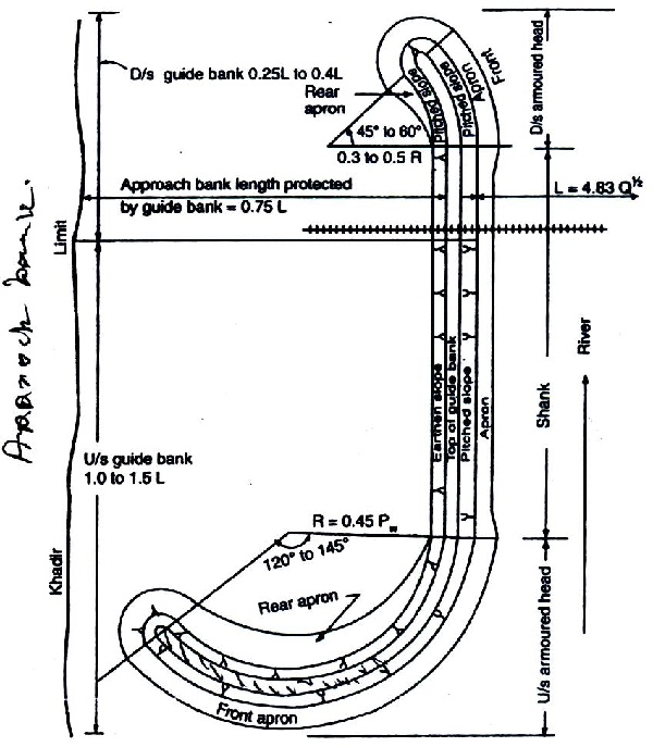
Figure: Layout of guide bank.
Functions of a Guide Bank: The functions served by a guide bank are (i) Economical spanning of a wide river, (ii) Safe and expeditions passage of floods, (iii) Protect adjacent lands, upstream of a weir or barrage from spills due to afflux caused by the barrage construction, (iv) control and confine the flow axially through a restricted waterway so that the river has no possibility to swing about and outflank the structure, (v) Prevent occurrence of crossflow immediately upstream of barrage, and (vi) Protect the approach embankments (on either side of a bridge extending from the river bank to the guide banks) from direct attack by the river.
Effects of Guide Banks: The effects of guide banks are (i) Increase in the rate at which flood wave passes down the river, (ii) Increase in maximum discharge at all points downstream, (iii) Rise in the water surface elevation of the river during flood, (iv) Increase in the velocity and scouring action through the embanked section, and (v) Reduction in water surface slope of the river above the embanked portion.
Classification of Guide Banks
1. According to Form in plan: The pair of guide banks may be parallel, divergent or convergent in plan upstream of the structure.
(a) Parallel guide banks. Where the river is likely to meander on both sides, parallel guide banks with suitable curved heads are essentially required to give uniform flow from the head of the guide bank to the work. Symmetrical and parallel guide bands figure are usually adopted unless local conditions warrant adoption of convergent or divergent banks; their suitability being indicated by model studies.
(b) Convergent guide banks: Convergent guide banks are rarely used. They have the disadvantage of excessive attack and heavy scour at the head and shoaling all along the shank rendering the end bays inactive.
Divergent guide banks. Divergent guide banks exercise an attracting influence on the flow and are indicated where approaching flow is oblique to the structure or work is located at one edge of khadir, in order to keep the flow active in the spans adjacent to them. However they provide relatively less protection to the approach embankment, under worst possible embayment Embayment. A localized widening of a river or channel brought out artificially or naturally, as compared to the equal length of parallel guide banks. The divergent guide banks thus require longer length in comparison to parallel guide banks for the same degree of protection to the approach embankment. They induce oblique flow onto the barrage and give rise to tendency of shoal formation in the centre due to larger waterway between curved heads.
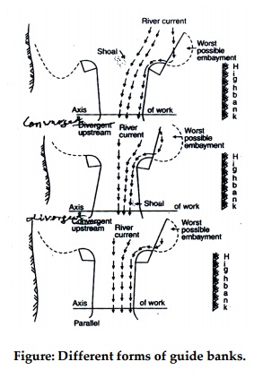
Figure: Different forms of guide banks.
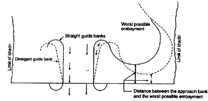
Figure: Extent of protection provided by the straight and divergent guide banks.
2. According to Geometrical Shape. On the basis of geometrical shape, the guide banks are classified as straight and elliptical with circular or multiradii curved head. Any other shape, if warranted by site conditions, is determined with the aid of hydraulic model studies.
Elliptical guide banks are preferred to the straight ones on account of the considerations (i) More suitable for wide flood plain rivers compared to straight guide banks, (ii) Flow hugs the guide banks all along their length due to gradual change in curvature, while separations of flow occurs in straight guide banks after the curved head which leads to obliquity of flow, and (iii) Provide better control on development and extension of meander loop towards the approach embankment.
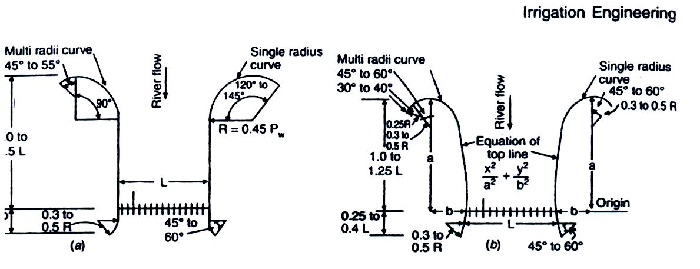
Figure: Geometrical shapes of guide bank (a) straight guide bank, (b) elliptical guide bank.
Related Topics