Chapter: 11th 12th std standard Geography earth space Higher secondary school College Notes
Indian Clinometer Survey
Booking of the Field Data
Traversing involves taking bearings and distances from one station to
the other until the last station is encountered. The survey book has two
parallel lines running through the centre of each page. Booking is usually
started from the last page of the book and from the bottom to the top of each
page. The stations are represented as triangles enclosing serial numbers or
letters specific to each station.
The
bearing from A to B is recorded at the top of the triangle enclosing A. The distance
from A to B is recorded at the base of the Triangle enclosing B. Any feature
encountered, such as the footpath or the stream, is sketched at the point it
crosses the survey line. Its distance from the previous station is recorded
just below the sketch.
The Magnetic Declination; (MD), of the area of the survey is recorded at
the bottom right hand corner, together with the date of completion of the
survey and the names of the persons conducting the survey.
Indian Clinometer Survey
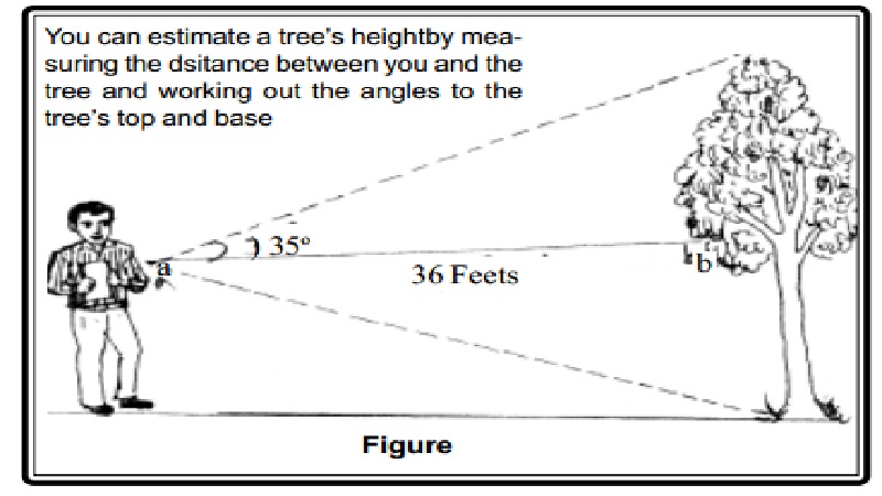
This is a simple instrument to measure the height of an object. Briefly
explained, if you know the distance ab and the angle A, you can determine the
length of side bc (or X). *Tangent is determined from a tangent chart.
Formula: ab x Tangent A = X Example: If ab = 36 feet
A = 35o x *Tan A = 0.7002 36 feet x 0.7002 = X
X = 25.2072 feet + Height of the man or height of the stole. *The height
is approximately 25 feet.
An Example: Foresters Measure Trees the Smart Way
Calculating how much wood there might be in a forest is a bit like
comparison shopping. Foresters do not count and measure every tree in the
forest. That would simply take too long. Instead, they sample.
'We use sampling principles every day in our own
lives,' says a Forester. If we're shopping for a stereo, he explains, we can't
always check every price in every store. Instead, we sample a few brands and
stores to get an estimate of what's available.
Similarly, foresters measure a few bits of the forest and, on the basis
of those bits, estimate what the whole forest contains. Many of the techniques
they use involve little more than careful measuring and some high-school
mathematics. The first step is to choose which bits to sample. It is important
to avoid picking samples that will give a false picture of the forest. The
solution is to choose the sample plots randomly.
You could just throw darts at a map and sample
where the darts land but affordable access is important. If your darts land
well beyond the reach of roads, costs will soon eat up the sampling budget.
Personal bias can be avoided by selecting locations on a map before going out
in the field, rather than just walking through the forest and choosing
good-looking trees. But once the locations are chosen, you have to stick with
them, no matter what you find when you actually visit them.
'If one of your plots is in a clearing with very few trees, it is
tempting to move it to an area with more trees. But you have to remember, that
clearing represents lots of other clearings in the forest.' For biological
studies, the most common approach to estimating the amount of wood is called a
fixed area plot. The plots can be any shape, but all plots within a study must
have exactly the same shape and dimensions. 'For estimating tree volume, fixed
area plot size is chosen with the aim of including 12 to 20 trees.'
The next step is to measure the trees within the plot. Although the goal
is to estimate volume, it is not easy to measure that directly without
destroying the tree. Instead, you measure the tree's height and its diameter
and use those two numbers to calculate the volume. You can determine the tree's
height by using trigonometry. If you measure the horizontal distance between
yourself and the tree, and measure the angles leading to the tree's top and
base, you have enough information to calculate the tree's height. That is where
you use the instrument called the Indian Clinometer.
Related Topics