Chapter: Civil Surveying : Advanced Topics in Surveying
Astronomical Surveying
ASTRONOMICAL SURVEYING
Celestial Sphere.
The millions of stars that we see
in the sky on a clear cloudless night are all at varying distances from us.
Since we are concerned with their relative distance rather than their actual
distance from the observer. It is exceedingly convenient to picture the stars
as distributed over the surface of an imaginary spherical sky having its center
at the position of the observer. This imaginary sphere on which the star appear
to lie or to be studded is known as the celestial sphere. The radius of the
celestial sphere may be of any value - from a
few thousand metres to a few thousand kilometers. Since the stars are very
distant from us, the center of the earth may be taken as the center of the
celestial sphere.
Zenith, Nadir and Celestial Horizon.
The Zenith (Z) is the point on the upper portion
of the celestial sphere marked by plumb line above the observer. It is thus the
point on the celestial sphere immediately above the observer's station.
The Nadir (Z') is the point on
the lower portion of the celestial sphere marked by the plum line below the
observer. It is thus the point on the celestial sphere vertically below the
observer's station. Celestial Horizon. (True or Rational horizon or geocentric
horizon): It is the great circle traced upon the celestial sphere by that plane
which is perpendicular to the Zenith-Nadir line, and which passes through the
center of the earth. (Great circle is a section of a sphere when the cutting
plane passes through the center of the sphere).
Terrestrial Poles and Equator, Celestial Poles and
Equator.
The terrestrial poles are the two points
in which the earth's axis of rotation meets the earth's sphere. The terrestrial
equator is the great circle of the earth, the plane of which is
at right
angles to the axis of rotation. The two poles are equidistant from it.
If the earth's axis of rotation is produced
indefinitely, it will meet the celestial sphere in two
points called the north and south celestial poles (P
and P'). The celestial equator is the
great circle of the celestial sphere in which it is
intersected by the plane of terrestrial equator.
1 CO-ALTITUDE OR ZENITH DISTANCE (Z) AND AZIMUTH
(A).
It is
the angular distance
of heavenly body from the
zenith. It is the
complement
or the
altitude, i.e z = (90 o - ?).
The azimuth of a heavenly body is the angle between
the observer's meridian and the vertical circle passing through
the body.
Determine the hour angle and declination of a star
from the following data:
(i) Altitude of the star = 22 o 36'
(ii) Azimuth of the star = 42 o W
(iii) Latitude of the place of observation = 40 o N.
Solution.
Since the
azimuth of the star is 42 o W, the star is in the western hemi-sphere.
In the
astronomical DPZM, we have
PZ = co-latitude = 90 o - 40 o = 50 o ;
ZM = co-altitude = 90 o - 22 o 36 o = 67
24'
; angle A = 42 o
Knowing
the two sides and the included angle, the third side can be calculated from
the
cosine formula
Thus, cos PM = cos PZ . cos ZM + sin
PZ. Sin ZM. cos A
= cos
50 o . cos
67 o 24'
+ sin 50 o . sin 67 o 24'. cos 42 o
= 0.24702
+ 0.52556 = 0.77258
\ PM = 39 o 25'
\Declination of the star = d= 90 o - PM = 90 o - 39 o 25' = 50 o
35'
N.
Similarly, knowing all the three sides, the hour angle H can
be calculated from Eq.
1.2
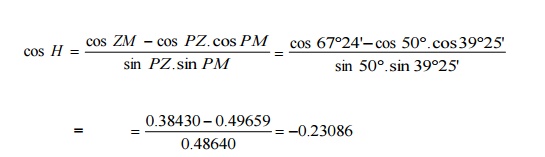
\ cos ( 180 o - H ) =
0.23086
\ 180 o - H = 76 o
39'
H
= 103 o 21'.
Related Topics